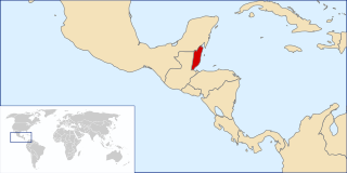
Belize, formerly known as British Honduras, is a Caribbean country located on the northeastern coast of Central America. Belize is bordered on the northwest by Mexico, on the east by the Caribbean Sea, and on the south and west by Guatemala. It has an area of 22,970 square kilometres (8,867 sq mi) and a population of 408,487 (2019). Its mainland is about 290 km (180 mi) long and 110 km (68 mi) wide. It has the lowest population and population density in Central America. The country's population growth rate of 1.87% per year is the second highest in the region and one of the highest in the Western Hemisphere.

Central America is sometimes defined as a subregion of the Americas. This region is bordered by Mexico to the north, Colombia to the southeast, the Caribbean Sea to the east and the Pacific Ocean to the west and south. Central America consists of seven countries: El Salvador, Costa Rica, Belize, Guatemala, Honduras, Nicaragua and Panama. The combined population of Central America is estimated at 44.53 million (2016).
Guatemala's major diplomatic interests are regional security and increasingly, regional development and economic integration.

Belize maintains 14 embassies to foreign countries, one consulate, and three missions to international organizations. In 1990, Belize became a member of the Organization of American States, and the Commonwealth of Nations in 1981.

The Central American river turtle, also known locally as the hickatee or tortuga blanca, is the only living species in the family Dermatemydidae. Its closest relatives are only known from fossils with some 19 genera described from a worldwide distribution from the Jurassic and Cretaceous. The species is currently found in the Atlantic drainages of Central America, specifically southern Mexico, Belize and Guatemala. It is a relatively large-bodied species, with historical records of 60 cm (24 in) stright carapace length and weights of 22 kg (49 lb); however, more recent records have found few individuals over 14 kg (31 lb) in Mexico or 11 kg (24 lb) in Guatemala.

Guatemala is divided into 22 departments which are in turn divided into 340 municipalities.

John David McAfee is an English-American computer programmer and businessman. He founded the software company McAfee Associates in 1987 and ran it until 1994, when he resigned from the company. McAfee Associates achieved early success as the creators of McAfee, the first commercial antivirus software, and the business now produces a range of enterprise security software. The company was purchased by Intel in 2011 and spun back out in 2017 with TPG Capital owning a majority stake, though the software has always borne the McAfee brand name. McAfee's wealth peaked in 2007 at $100 million, before his investments plummeted in the financial crisis of 2007–2008.

The Gulf or Bay of Honduras is a large inlet of the Caribbean Sea, indenting the coasts of Belize, Guatemala, and Honduras. From north to south, it runs for approximately 200 km from Dangriga, Belize, to La Ceiba, Honduras.

Amatique Bay is a large bay in the Gulf of Honduras, along the eastern coast of Guatemala and Belize. It stretches from Santo Tomás de Castilla in the south to Punta Gorda in the north, where it opens to the Caribbean Sea. Its south-eastern limits are marked by a small peninsula known as Punta de Manabique where a $27 million gas terminal is planned
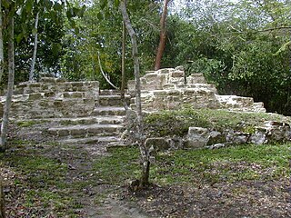
El Pilar is an ancient Maya city center located on the Belize-Guatemala border. The site is located 12 kilometres (7.5 mi) north of San Ignacio, Belize and can be accessed through the San Ignacio and Bullet Tree Falls on the Belize River. The name "El Pilar" is Spanish for "watering basin", reflecting the abundance of streams around the site and below its escarpment, which is rare in the Maya area.

St. John's College has three divisions and a number of central academic centres and activities. Through its divisions, it offers a wide variety of liberal arts and science courses at the secondary, British A-level, and United States junior college levels. St. John's College is a Roman Catholic institution in the Jesuit tradition, one of the oldest, largest, and most diverse educational institutions in Belize, founded by the Jesuits in 1887.

The Belizean–Guatemalan territorial dispute is an unresolved territorial dispute between the states of Belize and Guatemala, neighbours in Central America. The territory of Belize has been claimed in whole or in part by Guatemala since 1821.
Belizeans are people associated with the country of Belize through citizenship or descent. Belize is a multiethnic country with residents of African, Amerindian, European and Asian descent or any combination of those groups.
The following is an alphabetical list of topics related to the nation of Belize.

Wilfred Peter "Sedi" Elrington is a Belizean politician who has been the Foreign Minister of Belize since 2008.
Hispanic Belizeans, Latin Belizean or Belizean Mestizos are Belizeans of Hispanic and mestizo descent. Currently, they comprise around 52.9% of Belize's population.

San Antonio is a village in the Toledo District of Belize. It is the largest Maya settlement in Belize, with a population of approximately 1,000 people, predominantly Mopan Maya. About 88% of the inhabitants are Catholic, with 8% belonging to other Christian denominations, and 4% being non-denominational. Along with 29 other mission parishes in the Toledo District, it is pastored by Jesuits from St. Peter Claver church in Punta Gorda.

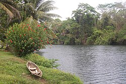
The extensive trade networks of the Ancient Maya contributed largely to the success of their civilization spanning three millennia. The Maya royals control and wide distribution of foreign and domestic commodities for both population sustenance and social affluence are hallmarks of the Maya visible throughout much of the iconography found in the archaeological record. In particular, moderately long distance trade of foreign commodities from the Caribbean and Gulf Coasts provided the larger inland Maya cities with the resources they needed to sustain settled population levels in the several thousands. Though the ruling class essentially controlled the trade economy, a middle merchant class supervised import and export from cities and trade ports. Not much is known of the Maya merchant class; however, merchants of royal lineage are sometimes represented in the iconography. Notably, a canoe paddle often accompanies the royal merchant depictions, signifying their association with marine resources. Water lilies are also a recognizable feature of Maya iconography, appearing on ceramics and murals in landlocked cities like Palenque where the lilies cannot grow, further indicating the important political symbolism of water connections. The dugout style canoes of the Maya and other small watercraft are also represented in various codices, sometimes ferrying royal figures or deities. The rich tradition of maritime trade has continued into the modern era, exemplified by the resource exploitation of the coastal lagoons and cay locations along the Caribbean coast of Mexico, Belize, Guatemala, and Honduras. Eventually, the intensification of maritime trade reliance aided in the collapse of interior Maya power regimes, shifting political influence to coastal polities such as Uxmal and Chichen Itza in the Terminal Classic. A seaborne trade economy would continue to dominate the Maya civilization until the period of European Contact.