Location
The middle part of the Ubangi, from Yakoma down to Mokoangai, is called the Dua. It appears to be the bed of an ancient, long and narrow lake. The waters draining the lake carved out the Zongo Gut, which cuts through a chain of hills that extends from east to west. Ascending the Ubangi from Zongo the rapids in the colonial era were named Zongo, Bonga, Belly, En Avant, Elephant and Mokuangi, and covered a distance of 24 miles (39 km). An 1888 map based on Alphonse van Gèle's observations shows the Songo rapids, then further east four rapids, ascending from southwest to northeast: Zawa Bonga, Belli, Mossuma and Mokuangai. Elephanten Insel was between Mossuma and Mokuangai.
The banks of the river in this section when Van Gele visited in 1887 were bordered by gentle slopes with alternating woods, plains, maize fields and banana plantations. The people around Mokuangi were Bakombe. Above Mokuangi the river came down from the northeast for about 50 kilometres (31 mi), and was about 4 metres (13 ft) deep and 800 to 900m wide (2625ft to 2953ft).
Early European presence
An expedition under Van Gèle left Equateur Station on 26 October 1887 in the steamer En Avant towing a large canoe that could hold 100 people. It reached Zongo on 21 November 1887, and took three weeks to ascend the rapids, passing Mokuangai on 11 December 1887. In 1889 Van Gèle and Georges Le Marinel studied the north shore of the Ubangi between Banzyville and Mokoangai and discovered the mouths of the Kuanga and Benghi rivers.
Louis Royaux (born 1866) joined the Congo Free State in 1892 and became the deputy of Florent-François-Marie Heymans in Zongo. He was then made station head in Banzyville and then Mokoangay. He "pacified" the regions for which he was responsible, before returning to Belgium in August 1895. Mokoangai was one or two hours upstream from the Elephant rapids. In 1905 it had a large plantation and farm, and well built houses that lodged one or two resident Europeans.
Yakoma is a town in the Nord-Ubangi province of the Democratic Republic of the Congo (DRC) and is the headquarters of the Yakoma Territory.

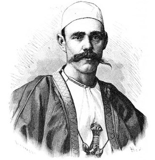
Alphonse van Gèle, also written van Gele or Vangele, was a Belgian soldier who served as the Vice-Governor General of the Congo Free State from December 1897 until January 1899. He established the Equator Station, or Station de l’Équateur, today Mbandaka, and concluded a treaty with the powerful Zanzibar trader Tippu Tip at the Stanley Falls station, today Kisangani. He is known for having confirmed that the Uele River was the upper part of the Ubangi River.
Uele District was a district of the Congo Free State and the Belgian Congo. It roughly corresponded to the current provinces of Bas-Uélé and Haut-Uélé.
Ubangi District was a district of the Congo Free State, Belgian Congo and Democratic Republic of the Congo. It went through various significant changes in extent.
The Mbari River is a river of the Central African Republic. It is a right tributary of the Mbomou River not far to the north of where the Mbomou joins the Uele River to form the Ubangi River.
Jules Alexandre Milz was a Belgian soldier who was active in exploring the northeast of the Congo Free State. He traveled extensively in Uele District, where he resolved the question of whether the Uele River was the upper portion of the Ubangi River. He was second in command of an expedition to the Nile in 1891–1892, and took over command after the leader died.
The Ibenga River is a river of the Republic of the Congo, a right tributary of the Ubangi River.

The Lobaye River is a river of the Central African Republic, a right tributary of the Ubangi River.

Edmond-Winnie-Victor Hanssens was a Belgian soldier and colonial administrator. He did much to establish the Belgian presence on the Upper Congo River in the last two years of his life.
Arvid Mauritz Wester was a Swedish soldier who was active in the service of the Belgians in the Congo. For almost two years he commanded the remote station at Stanley Falls, where he had to deal with hostile local people and Arabs.

Sten Edvard Gleerup, or Edde Gleerup, was a Swedish soldier and explorer. He was the first Swede and eighth European to cross Africa.
Louis-Gustave Amelot was a Belgian mechanical engineer who served with the International African Association, the precursor to the Congo Free State.

Léon Roget was a Belgian soldier and colonial administrator who was active in the Congo Free State. He was the first commander of the Force Publique, the armed force used to police the colony.

Willem Frans Van Kerckhoven, or Guillaume François van Kerckhoven was a Belgian soldier, explorer, colonial administrator who was active in the service of the International Association of the Congo and the subsequent Congo Free State. He is known for his extended expedition through the Uele River basin and onward towards the Nile, during which he cleared the Arab slave traders from the region and established a Belgian presence. He died in an accident before reaching the Nile.
Théodore Victor Edouard Adolphe Arthur Nilis was a Belgian soldier and colonial official.

Léon-Charles-Édouard Hanolet was a Belgian soldier, explorer and colonial administrator. He is known for his explorations in 1894–1895 in what is now the Central African Republic, which led to an agreement between France and Belgium that the Ubangi-Mbomou rivers would form the boundary between their territories. He defended the Lado Enclave against the retreating Mahdist forces in 1898.
Georges-Edouard le Marinel was a Belgian soldier, engineer, explorer and colonial administrator. He is known for leading explorations of the country around the Ubangi River and Mbomou River, which later became the boundaries between French and Belgian territory.

The En Avant (Forward) was a small steam launch used in the early days of European exploration of the Congo River basin. It was carried in sections past the cataracts of the lower Congo, reassembled at Stanley Pool and launched in December 1881, the first powered vessel on the long navigable section between the cataracts and the Stanley Falls . In the years that followed it played an important role in carrying the Europeans up and down the river and its tributaries as they established trading stations.

Sultan Djabir was ruler of a region on the Uele River in what is now the Democratic Republic of the Congo. He engaged in the ivory and slave trade with Muslims from the north and with Belgians from the south. Eventually he was forced to flee to the Sudan when he refused to pay tribute to the Congo Free State.
This page is based on this
Wikipedia article Text is available under the
CC BY-SA 4.0 license; additional terms may apply.
Images, videos and audio are available under their respective licenses.
