
The Central African Republic is a landlocked country in Central Africa. It is bordered by Chad to the north, Sudan to the northeast, South Sudan to the southeast, the Democratic Republic of the Congo to the south, the Republic of the Congo to the southwest, and Cameroon to the west.
The history of the Central African Republic is roughly composed of four distinct periods. The earliest period of settlement began around 10,000 years ago when nomadic people first began to settle, farm and fish in the region. The next period began around 10,000 years prior.

The politics of the Central African Republic formally take place in a framework of a semi-presidential republic. In this system, the President is the head of state, with a Prime Minister as head of government. Executive power is exercised by the government. Legislative power is vested in both the government and parliament.

Bangui is the capital and largest city of the Central African Republic. It was established as a French outpost in 1889 and named after its location on the northern bank of the Ubangi River ; the Ubangi itself was named from the Bobangi word for the "rapids" located beside the settlement, which marked the end of navigable water north from Brazzaville. The majority of the population of the Central African Republic lives in the western parts of the country, in Bangui and the surrounding area.

François Bozizé Yangouvonda is a Central African politician who was President of the Central African Republic from 2003 to 2013.
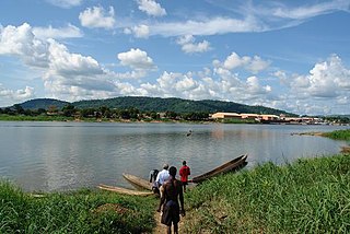
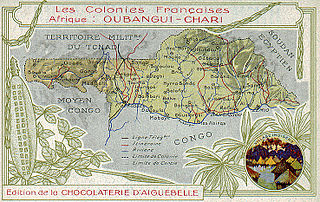
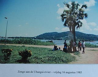
The Ubangi River, also spelled Oubangui, is the largest right-bank tributary of the Congo River in the region of Central Africa. It begins at the confluence of the Mbomou and Uele Rivers and flows west, forming the border between Central African Republic (CAR) and Democratic Republic of the Congo. Subsequently, the Ubangi bends to the southwest and passes through Bangui, the capital of the CAR, after which it flows south – forming the border between Democratic Republic of the Congo and Republic of the Congo. The Ubangi finally joins the Congo River at Liranga.

Équateur was a province in the northwest of the Belgian Congo and the successor Republic of the Congo, now known as Democratic Republic of the Congo. It had its origins in the Équateur District of the Congo Free State, the private property of King Leopold II of Belgium. It was upgraded to the status of a province in 1917. Between 1933 and 1947 it was named Coquilhatville. In 1962 it was divided into three smaller provinces, but there were recombined in 1966. Équateur was one of the eleven provinces of the Democratic Republic of the Congo until 2015, when it was split into the new, smaller Équateur province, as well as the Tshuapa, Mongala, Nord-Ubangi and Sud-Ubangi provinces.
Sibut, formerly Fort Sibut is the capital of Kémo, one of the 16 prefectures of the Central African Republic. An important transport hub, it is situated 188 km (117 mi) north of the capital Bangui and is known for its market.

The Central African Republic Bush War was a civil war in the Central African Republic which lasted from 2004 to 2007 between Union of Democratic Forces for Unity (UFDR) rebels and government forces. The rebellion began after François Bozizé seized the nation's presidency in 2003. Actual fighting began in 2004. Around 10,000 people were displaced because of the civil unrest.
Bétou is a town on the right bank of the Ubangi River in the Likouala Department, Republic of the Congo. Bétou is a "sous-prefecture" and has its own mayor. It is the border town with the Central African Republic (CAR), approximately 90 km (56 mi) from the border by road or 45 km (28 mi) by river. The town is linked to Bangui, the capital of CAR, by a relatively good road but suffers from very poor road access to the south of the Republic of Congo, with the vast majority of travelers arriving by river. The town has a disused air-strip.
Sud-Ubangi is one of the 21 new provinces of the Democratic Republic of the Congo created in the 2015 repartitioning. It lies in the northwest of the country on the Ubangi River.

The Central African Republic Civil War is an ongoing civil war in the Central African Republic (CAR) involving the government, rebels from the Séléka coalition, and Anti-balaka militias.

Séléka CPSK-CPJP-UFDR was an alliance of rebel militia groups that subjugated the Central African Republic (CAR) on 24 March 2013. After its official dissolution in September 2013, the remaining rebel groups became known as Ex-Séléka. Séléka leader Michel Djotodia became the nation's president from March 2013 until his resignation in January 2014. Members of Séléka were almost all Muslim.
A coup d'état occurred in March 2003 in the Central African Republic when the forces of General François Bozizé marched on Bangui, the country's capital, while President Ange-Félix Patassé was at a regional conference in Niger.
The following lists events that happened during 2013 in the Central African Republic.

Central African Republic–France relations are foreign relations between the Central African Republic (CAR) and France. Both nations are members of the Francophonie and the United Nations.
The following is a timeline of the history of the city of Bangui, Central African Republic.
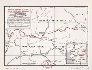
The Central African Republic–Democratic Republic of the Congo border is 1,747 km in length and runs from the tripoint with the Republic of the Congo in the west to the tripoint with South Sudan in the east.

Léon-Charles-Édouard Hanolet was a Belgian soldier, explorer and colonial administrator. He is known for his explorations in 1894–1895 in what is now the Central African Republic, which led to an agreement between France and Belgium that the Ubangi-Mbomou rivers would form the boundary between their territories. He defended the Lado Enclave against the retreating Mahdist forces in 1898.
Events in the year 2021 in the Central African Republic.


