
Nagorno-Karabakh is a landlocked region in the South Caucasus, within the mountainous range of Karabakh, lying between Lower Karabakh and Zangezur, and covering the southeastern range of the Lesser Caucasus mountains. The region is mostly mountainous and forested.

Artsakh, officially the Republic of Artsakh or the Nagorno-Karabakh Republic, is a breakaway state in the South Caucasus supported by Armenia, whose territory is internationally recognized as part of Azerbaijan. Artsakh controls part of the former Nagorno-Karabakh Autonomous Oblast, including the capital of Stepanakert. It is an enclave within Azerbaijan. Its only overland access route to Armenia is via the 5 km (3.1 mi) wide Lachin corridor which is under the control of Russian peacekeepers.

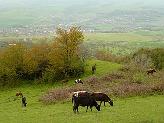
Shahumyan Province was a province of the self-proclaimed Republic of Artsakh, de jure part of the Republic of Azerbaijan. The capital of the province was Karvachar. Shahumyan Province had 17 communities of which one is considered urban and 16 are rural. Its bordered Martakert Province to the east, Kashatagh Province to the south, Gegharkunik and Vayots Dzor provinces of Armenia to the west and Dashkasan, Goygol and Goranboy districts of Azerbaijan to the north.
Nagorno-Karabakh is located in the southern part of the Lesser Caucasus range, at the eastern edge of the Armenian Highlands, encompassing the highland part of the wider geographical region known as Karabakh. Under Russian and Soviet rule, the region came to be known as Nagorno-Karabakh, meaning "Mountainous Karabakh" in Russian. The name Karabakh itself was first encountered in Georgian and Persian sources from the 13th and 14th centuries to refer lowlands between Kura and Aras rivers and adjacent mountainous territory.

The Nagorno-Karabakh Autonomous Oblast (NKAO) was an autonomous oblast within the Azerbaijan Soviet Socialist Republic, mostly inhabited by ethnic Armenians.
Karabakh is a geographic region in present-day southwestern Azerbaijan and eastern Armenia, extending from the highlands of the Lesser Caucasus down to the lowlands between the rivers Kura and Aras.

Qızıl Kəngərli is a village in the Agdam District of Azerbaijan.

Aşağı Fərəcan is a village in the Lachin District of Azerbaijan.
Əhmədli is a village in the Lachin District of Azerbaijan.
Alkhasly is a village in the Lachin District of Azerbaijan.
Hal is a village in the Qubadli District of Azerbaijan.
Çaylı is a village in the Tartar District of Azerbaijan. The village is on the cease-fire line between the armed forces of the breakaway state Republic of Artsakh and those of Azerbaijan.

Talish is a village in the Tartar District in Azerbaijan. The village had an ethnic Armenian-majority population prior to the 2020 Nagorno-Karabakh war, and also had an Armenian majority in 1989.
Mollalar is a village in the Lachin District of Azerbaijan. Close by is the ghost town of Kizilja.
Petrosashen is a village in the Khojavend District of Azerbaijan. The village had an ethnic Armenian-majority population prior to the 2020 Nagorno-Karabakh war, and also had an Armenian majority in 1989.
Melikli is a village of the Zangilan District in Azerbaijan.

Hacıkənd is a village in the Kalbajar District of Azerbaijan.
Qarakeçdi is a village in the Lachin District of Azerbaijan.
Hacsamlı is a village in the Lachin District of Azerbaijan.

Law on Abolishment of Nagorno-Karabakh Autonomous Oblast is the Resolution No. 279-XII passed by the National Assembly of Azerbaijan and signed into law by the President of Azerbaijan Ayaz Mutalibov on November 26, 1991. The law had been prompted by a vote of National Assembly of Nagorno-Karabakh in favor of uniting itself with Armenia on 20 February 1988. The vote was followed by a referendum in 1988 which was boycotted by the Azerbaijani population of the Oblast; most voted in favor of independence. While these votes and elections had mainly been conducted in a relatively peaceful manner, in the following months, as the Soviet Union disintegrated, it gradually grew into an increasingly violent conflict between ethnic Armenians and ethnic Azerbaijanis. Both sides claimed that ethnic cleansing was being carried out. The declaration of secession from Azerbaijan was the final result of a territorial conflict regarding the land.


