
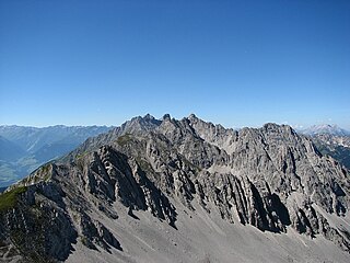
The Karwendel is the largest mountain range of the Northern Limestone Alps. It is located on the Austria–Germany border. The major part belongs to the Austrian federal state of Tyrol, while the adjacent area in the north is part of Bavaria, Germany. Four chains stretch from west to east; in addition, there are a number of fringe ranges and an extensive promontory (Vorkarwendel) in the north.

Seefeld in Tirol is an old farming village, now a major tourist resort, in Innsbruck-Land District in the Austrian state of Tyrol with a local population of 3,312. The village is located about 17 km (11 mi) northwest of Innsbruck on a plateau between the Wetterstein mountains and the Karwendel on a historic road from Mittenwald to Innsbruck that has been important since the Middle Ages. It was first mentioned in 1022 and since the 14th century has been a pilgrimage site, benefiting not only from the visit of numerous pilgrims but also from its stacking rights as a trading station between Augsburg and the Venice. Also since the 14th century, Tyrolean shale oil has been extracted in the area. Seefeld was a popular holiday resort even before 1900 and, since the 1930s, has been a well known winter sports centres and amongst the most popular tourist resorts in Austria. The municipality, which has been the venue for several Winter Olympics Games, is the home village of Anton Seelos, the inventor of the parallel turn.
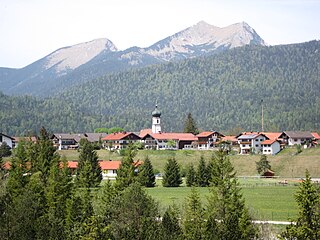
Krün is a municipality in the Upper Bavarian district of Garmisch-Partenkirchen. It belongs with Garmisch-Partenkirchen as district capital and cultural center as well as other municipalities to the region Werdenfelser Land. A few kilometers south runs the German-Austrian border.

The Wetterstein mountains, colloquially called Wetterstein, is a mountain group in the Northern Limestone Alps within the Eastern Alps, crossing the Austria–Germany border. It is a comparatively compact range located between Garmisch-Partenkirchen, Mittenwald, Seefeld in Tirol and Ehrwald along the border between Germany (Bavaria) and Austria (Tyrol). Zugspitze, the highest peak is at the same time the highest mountain in Germany.
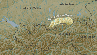
The Bavarian Prealps are a mountain range within the Northern Limestone Alps along the Austria–Germany border. They include the Bavarian Prealp region between the river Loisach to the west and the river Inn to the east; the range is about 80 kilometres (50 mi) long and 20–30 kilometres (12–19 mi) wide. The term is not defined politically, but alpine-geographically because, although the range is mostly located in Bavaria, southeast Germany, small areas of the Bavarian Prealps lie in the state of Tyrol, Austria.
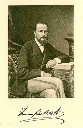
Hermann von Barth was a famous German mountaineer.
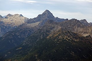
The Hochvogel is a 2,592-metre-high (8,504 ft) mountain in the Allgäu Alps. The national border between Germany and Austria runs over the summit. Although only the thirteenth highest summit in the Allgäu Alps, the Hochvogel dominates other parts of Allgäu Alps and the other ranges in the immediate neighbourhood. This is due to the fact that the majority of the higher peaks are concentrated in the central and western part of the Allgäu Alps. The Hochvogel stands on its own in the eastern part of the mountain group; the nearest neighbouring summits are 200 to 300 metres lower. Experienced climbers can ascend the summit on two marked routes.

The Östliche Karwendelspitze (2,537 m) is a mountain formed from Wetterstein limestone in the Karwendel mountains on the border between Bavaria and Tyrol. It is the highest mountain of the Northern Karwendel chain and the highest German peak in the Karwendel. It was first climbed by Hermann von Barth on 4 July 1870.

A summit cross is a Christian cross on the summit of a mountain or hill that marks the top. Often there will be a summit register (Gipfelbuch) at the cross, either in a container or other weatherproof case.
The Alpine Club Guides were the standard series of alpine climbing guidebookss that cover all the important mountain groups in the Eastern Alps. They were produced jointly by the German (DAV), Austrian (ÖAV) and South Tyrol Alpine Clubs (AVS). They had been published since 1950 by the firm of Bergverlag Rother in Munich, Germany.

The Mieming(er) Range, Mieminger Chain or Mieminger Mountains, is a mountain range of the Northern Limestone Alps in the Eastern Alps. It is located entirely in Austria within the state of Tyrol. This sub-group is somewhat in the shadows of its more famous neighbour, the Wetterstein to the north. Whilst the region around the Coburger Hut and the lakes of Seebensee and Drachensee in the west and the Hohe Munde in the extreme east receive large numbers of visitors, the less developed central area remains very quiet. The Hohe Munde is also a popular and challenging ski touring destination.

The North Tyrol Limestone Alps are a mountain range located in Austria and, marginally, in Germany.

Hinterriß is a Tyrolean village in Schwaz District, Austria, located at the Rißbach river at a height of 928 metres. Legally, Hinterriß is split up between the municipalities of Vomp and Eben am Achensee.

The Hinterau valley is a valley crossing the Karwendel range from east to west. The Isar has its official source in the Hinterau valley.
The Nordkette, also variously called the North Chain, Northern Range, rarely the Inn Valley Range or Inn Valley Chain (Inntalkette), is a range of mountains just north of the city of Innsbruck in Austria. It is the southernmost of the four great mountain chains in the Karwendel. To the west it is linked by the Erl Saddle to the Erlspitze Group, to the east via the Stempeljoch saddle to the Gleirsch-Halltal Range. To the south it is bounded by the Inn valley. Its highest summit is the Kleiner Solstein in the west of the range.

The Große Solstein is a mountain, 2,541 m (AA) high, on the western corner of the Nordkette range in the Karwendel mountains near Zirl in the Austrian state of Tyrol. Its summit may be ascended on various mountain tour routes either from the Solsteinhaus or from the New Magdeburg Hut. These routes are described as not difficult but require stamina. The crossing to the higher peak of the Kleiner Solstein, despite its name the highest in the Nordkette, is described in that article.

The Hohe Warte is a mountain, 2,597 m (AA) in height, in the Karwendel range in Austria. It is located between the Kleiner Solstein to the west and the Hintere Brandjochspitze to the east, in the Nordkette in the state of Tyrol, north of the Innsbruck quarter of Kranebitten and has a prominence of at least 77 metres.

The Nördlinger Hut is an Alpine Club hut belonging to the German Alpine Club that is situated at a height of 2,238 m (AA) south of the summit of the Reither Spitze in the Austrian state of Tyrol. It is thus the highest refuge hut in the entire Karwendel range. It is located in the westernmost part of the Karwendel Alps, the Erlspitze Group, above the village and ski resort of Seefeld. From the hut there are expansive views over the Stubai Alps, the Inn valley and the Wetterstein Mountains.

Juifen is a summit of the Karwendel range in the Austrian state of Tyrol.

Franz Oppurg was an Austrian mountain climber. Having climbed from a young age, he became a mountain guide and rescuer, and did a number of first ascents in the winter of mountains in his native Karwendel. He was also the first climber to achieve a solo ascent of Mount Everest.


