
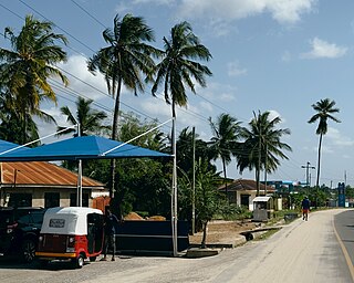
Kivukoni is an administrative ward of the Ilala Municipical Council of the Dar es Salaam Region in Tanzania. Kivikoni's name come from the Swahili word meaning "a crossing place". The ward is bordered by Upanga East ward to the west, Kisutu ward to the southwest, and Kigamboni ward across the Kivukoni channel. The ward covers an area of 2.387 km2 (0.922 sq mi). Kivukoni ward is one of the most important wards in the country, as it is home to the Ikulu, which is the home of the president of Tanzania. Kivukoni ward is also home to the National Museum of Tanzania. According to the 2012 census, the ward had a total population of 6,742.
Makuyuni is an administrative ward in the Monduli district of the Arusha Region of Tanzania. In 2016 the Tanzania National Bureau of Statistics report there were 12,529 people in the ward, from 11,228 in 2012.
Moita is an administrative ward in the Monduli District of the Arusha Region of Tanzania. In 2016 the Tanzania National Bureau of Statistics report there were 12,654 people in the ward, from 11,340 in 2012.
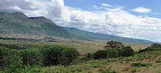
Monduli Juu is an administrative ward in the Monduli District of the Arusha Region of Tanzania. In 2016 the Tanzania National Bureau of Statistics report there were 12,457 people in the ward, from 15,914 in 2012.
Selela is an administrative ward in the Monduli District of the Arusha Region of Tanzania. The name Selela means Clean water in the Maasai language.
Sepeko is an administrative ward in the Monduli District of the Arusha Region of Tanzania. In 2016 the Tanzania National Bureau of Statistics report there were 13,550 people in the ward, from 16,720 in 2012.

Sekei is an administrative ward and district capital located in the Arusha City Council of Arusha Region in Tanzania. The ward is bordered by Kaloleni ward to the west, Sokon II ward to the north, Kimandolu ward to the east, Themi to the south and, a tiny portion of Kati ward to the southeast. The name sekei comes from the Masai word seki which is a type of tree that grew there before settlement. Sekei ward was officially established in 1969 and is the location of the headquarters of Arusha City Council.

Kinondoni is an administrative ward in the Kinondoni District of the Dar es Salaam Region in Tanzania. The ward is bordered to the east by Mikocheni and Mwananyamala wards, to the west by Hananasif ward, and to the north by Msasani ward. The ward is home to the headquarters for the National Muslim Council of Tanzania (BAKWATA) with its grand Mosque. The ward is also the heaquarters of Tanzania's second largest political party Chadema. According to the 2012 census, the ward has a total population of 21,239.

Makurumla is an administrative ward in Ubungo District of the Dar es Salaam Region in Tanzania. The Kinondoni Municipal District's Ndugumbi ward borders the ward on the north. Mzimuni Ward to the east, Mburahati and Mabibo to the south were its neighbors. Lastly, via Manzese ward towards the west. In 2016 the Tanzania National Bureau of Statistics report there were 79,331 people in the ward, from 63,352 in 2012.

Mzimuni is an administrative ward in Kinondoni District of the Dar es Salaam Region in Tanzania. The ward's northern boundaries are formed by the wards of Ndugumbi and Magomeni. Upanga West and Jangwani wards of Ilala MC surround the ward on the east, and Kigogo ward borders it on the south. The Makurumla and Mburahati wards of Ubungo MC are to the west. The ward is home to the Mwalimu Nyerere Memorial House. In 2016 the Tanzania National Bureau of Statistics report there were 26,905 people in the ward, from 21,486 in 2012.
Ndugumbi is an administrative ward and district capital of the Kinondoni District of the Dar es Salaam Region in Tanzania. Tandale and Makumbusho ward border the ward to the north, Mzimuni to the east, Makurumla to the south and Manzese on the west. The last two being located in Ubungo District. In 2016 the Tanzania National Bureau of Statistics report there were 46,134 people in the ward, from 36,841 in 2012.

Ilala or Ilala Ward is an administrative ward of the Ilala District of the Dar es Salaam Region in Tanzania. The Kigogo ward of the Kinondoni District borders the ward to the north, and the Mchikichini and Gerezani wards to the east. The Temeke District wards of Keko, Chang'ombe, and Temeke border the ward to the south. Buguruni encircles the ward to the west. In 2016 the Tanzania National Bureau of Statistics report there were 38,923 people in the ward, from 31,083 in 2012.

Kisutu is an administrative ward of the Ilala Municipical Council of the Dar es Salaam Region in Tanzania. Upanga East ward and Kivukoni ward both border the ward to the north and north-east. The ward is bordered to the south by Mchafukoge ward and to the west by Jangwani ward. The ward hosts the Channel 10 Television Station formerly known as Dar es Salaam Television Station at Zaramo Street in Kisutu ward. In 2016 the Tanzania National Bureau of Statistics report there were 10,404 people in the ward, from 8,308 in 2012.

Mchafukoge is an administrative ward and district capital of the Ilala district in the Dar es Salaam Region of Tanzania. Kisutu and Kivukoni wards form the ward's northern boundary. The Dar es Salaam Harbor forms its eastern border. The Temeke District wards of Kurasini and Keko border it on the south. Kariakoo and Jangwani wards border the ward to the west. The ward is home to the Uhuru Monument, the Central Railway Station, and the headquarters for Tanzania Revenue Authority at Mapato House. In 2016 the Tanzania National Bureau of Statistics reported there were 13,384 people in the ward, from 10,688 in 2012.

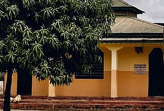
Kibada is an administrative ward in the Kigamboni district of the Dar es Salaam Region of Tanzania. The Temeke District's Kijichi and Toangoma wards border the ward on the south and west, and Mjimwema and Kisarawe II wards border it on the east. The ward is bordered to the north by Vijibweni. The ward is famous for its mango production.
Kisarawe II or unofficially East Kisarawe is an administrative ward in the Kigamboni district of the Dar es Salaam Region of Tanzania. The Kibada and Mjimwema form the ward's northern border. East is Somangila. Pembamnazi borders it to the south. Toangoma in the Temeke District, as well as Vianzi and Vikindu in the Pwani Region's Mkuranga District, border the west. Since Kisarawe II is the district's top agricultural producer, it is known as Kigamboni's "ricebowl" and "food basket". In 2016 the Tanzania National Bureau of Statistics report there were 10,401 people in the ward, from 8,306 in 2012.
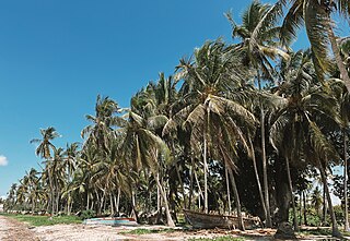
Pembamnazi, also known as Pemba Mnazi, is an administrative ward in the Kigamboni district of Dar es Salaam Region in Tanzania. The Indian Ocean forms the ward's eastern and southern boundaries. The Pwani Region's Mkuranga District's Shungubweni and Vianzi Wards are to the west. The ward is bordered to the north by the wards of Kisarawe II and Kimbiji. In 2016 the Tanzania National Bureau of Statistics report there were 12,112 people in the ward, from 9,672 in 2012.
Vijibweni is an administrative ward in the Kigamboni district of the Dar es Salaam Region of Tanzania. The Tungi and Mjimwema form the ward's northern and eastern borders, respectively. In the Temeke District, it is bordered to the south by Kibada and to the west by Kijichi, Mtoni, and Kurasini. Kurasini is connected to Vijibweni by the iconic Nyerere Bridge. With seven major firms situated there, Vijibweni is home to the largest manufacturing industries in the entire District. In 2016 the Tanzania National Bureau of Statistics report there were 36,327 people in the ward, from 29,010 in 2012.
Matongo (Tarime) is a ward in the Tarime District of the Mara Region of Tanzania, East Africa. In 2016 the Tanzania National Bureau of Statistics report there were 21,160 people in the ward, from 19,176 in 2012.
Simbo is an administrative ward in Kigoma Rural District of Kigoma Region in Tanzania. Prior to 2014 the ward was in the Uvinza District before moving to the Kigoma District.

