
Meghalaya is a hilly state in northeastern India. The name means "the abode of clouds" in Sanskrit. The population of Meghalaya as of 2016 is estimated to be 3,211,474. Meghalaya covers an area of approximately 22,430 square kilometres, with a length to breadth ratio of about 3:1.

Nagaland is a state in northeastern India. It borders the state of Assam to the west, Arunachal Pradesh and Assam to the north, Myanmar to the east, and Manipur to the south. The state capital is Kohima, and the largest city is Dimapur. It has an area of 16,579 square kilometres (6,401 sq mi) with a population of 1,980,602 per the 2011 Census of India, making it one of the smallest states of India. Nagaland is one of three states in India where the population is mostly Christian.

Mizoram is a state in northeastern India, with Aizawl as its capital city. The name is derived from "Mizo", the name of the native inhabitants, and "Ram", which means land, and thus Mizoram means "land of the Mizos". Within the northeast region, it is the southernmost landlocked state, sharing borders with three of the Seven Sister States, namely Tripura, Assam and Manipur. The state also shares a 722-kilometre border with the neighbouring countries of Bangladesh and Myanmar.

Mokokchung (Pron:/ˌməʊkɒkˈtʃʌŋ/) is a town and a municipality in Mokokchung district in the Indian state of Nagaland. It is the district headquarters as well as the main urban hub of Mokokchung district. Mokokchung is the cultural nervecentre of the Ao people and is economically and politically the most important urban centre in northern Nagaland. In fact it is third most important urban hub in all of Nagaland after Dimapur and Kohima. Besides this the Government of Nagaland has also recognised Mokokchung district as 'Land of Pioneers' because this place has produced a great number of luminaries in many fields. The town is made up of 16 wards of which Kumlong, Sangtemla, Alempang and Yimyu are the largest. Mokokchung is particularly noted for its extravagant Christmas, New Year, Moatsu and Tsungremong celebrations. Its tradition of celebrating Christmas and New Year midnight celebrations in the main town square is regarded as one of the unique features of Mokokchung. Historically, Mokokchung was one of the first Naga Hills sites where the Assam Rifles, led by Britishers, established their outposts in the later part of the 19th century. Much of the town initially grew around this post located in the DC Hill. The British administration was then gradually extended eastwards towards the remoter parts of the Naga Hills.

The Ao are one of the major Naga tribes of Nagaland, Northeast India. They were the first Naga tribe to embrace Christianity and by virtue of this development the Aos availed themselves to Western education that came along with Christianity. In the process the Aos became the pioneering tribe among the Nagas in many fields. Christianity first entered into the Ao territory when an American Baptist missionary, Edwin W. Clark, reached an Ao village called Molungkimong in 1872. Their main territory is from Tsula (Dikhu) Valley in the east to Tsurang (Disai) Valley in the west in Mokokchung district. They are well known for multiple harvest festivals held each year.

Mouling National Park is a national park located in the Indian state of Arunachal Pradesh, spread primarily over the Upper Siang district and parts of the West Siang and East Siang district. It was the second national park to be created in the state, after Namdapha National Park in 1972. The Mouling National Park and the Dibang Wildlife Sanctuary are located fully or partly within Dihang-Dibang Biosphere Reserve.

Mokokchung (Pron:/ˌməʊkɒkˈtʃʌŋ/) is a district of Nagaland state in India. The town of Mokokchung is its headquarters. It is mainly occupied by the Ao Naga tribe who consider it their home. It is bounded by the state of Assam to its north, Wokha district to its west, Tuensang and Longleng district to its east, and Zunheboto district to its south.

Tuensang (Pron:/ˌtjuːənˈsæŋ/) is a town in Nagaland, India, with a population of 36,774,. It is the headquarters of the Tuensang district, the easternmost and the largest district of Nagaland, bordering with Myanmar. The town was founded in 1947 for the purpose of administrating the erstwhile North Eastern Frontier Agency (NEFA) that comprised the present day Tuensang, Mon, Longleng, Kiphire and Noklak districts. Nowadays, these four districts combined together are also known as Eastern Nagaland.
Ungma is a historic village situated 10 km south of the heart of Mokokchung town in India. Ungma is one of the most ancient Ao villages and of great tourist interest to view the folklore, customs and traditions of Ao Naga. Ungma is one of the more developed villages in Nagaland.
Molung or new Molung or Molungyimsen is an Ao village located in the Jangpetkong range in Mokokchung District. It was formed on 24 October 1876, and from here the seeds of Christianity and Church that was first planted at Molungkimong on 22 December 1872 by Dr EW Clark, further progressed to other parts of Nagaland. An ancient leechi tree, believed to be planted by Dr E W Clark, the first American Missionary to the erstwhile Naga Hills, is found here.
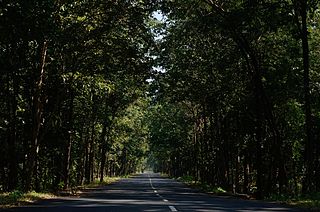
Yimyu is one of the 15 wards that make up Mokokchung town in India. It is an extensive area and forms the northwestern part of Mokokchung. Until 2003, Yimyu was a separate town and not under Mokokchung Municipal Council. However the last two decades has seen the gradual expansion of the settlements of both Yimyu and Mokokchung and had become a continuous settlement area. In 2003, Yimyu was formally incorporated as part of Mokokchung town. The Mariani-Mokokchung Highway passes through this ward. Mokokchung District Jail and DIET College are located here.

Kalaghatagi is an administrative division, or Taluka, in the Dharwad district of the Indian state of Karnataka.
Social forestry is the management and protection of forests and afforestation of barren and deforested lands with the purpose of helping environmental, social and rural development. The term social forestry was first used in 1976 by The National Commission on Agriculture, when the government of India aimed to reduce pressure on forests by planting trees on all unused and fallow lands. It was intended as a democratic approach to forest conservation and usage, maximizing land utilization for multiple purposes.
Longkhum is a village located 17 km south-west of Mokokchung, in Nagaland, North-East India. It is situated at an altitude of 1846 m above sea level.
Changtongya is a hilly town in Mokokchung district of Nagaland. Located around 40 km north of Mokokchung and 40 km south of Tuli, it lies midway between the two largest urban centres of the district. The town is located at an altitude of 954 metres above sea level. Ao is the language spoken here.

Tuli is a town in the Mokokchung district of the Nagaland state, India. It is located on the right bank of Milak river and is 80 km north of Mokokchung. Changtongya, the nearest Naga town is 40 km south of Tuli. It is here that the Langpangkong Range gently rises above the Melak plains. As such the topography of Tuli is marked by low rolling hills and a gentle plain. The Ao language is spoken here. The town consists of two main areas, Tuli headquarters and Tzudikong.

National Highway 202 is a National Highway in India that links Mokokchung to Imphal and runs for a distance of 460 km (290 mi)
Nungba is a small town surrounded by a low-lying hill ranges and rivers, an extension of eastern Indian Himalayas. The highest point of Nungba "Ramphaan But" which means "Viewpoint" stands high at the centre of the town.

National Highway 2 is a national highway in India that runs from Dibrugarh in Assam to Tuipang in Mizoram. This national highway passes through the Indian states of Assam, Nagaland, Manipur and Mizoram. This national highway is 1,325.6 km (823.7 mi) long. Before renumbering of national highways, NH-2 was variously numbered as old national highways 37, 61, 39, 150 and 54.
National Highway 702D, commonly called NH 702D is a national highway in states of Nagaland and Assam in India. It is an offshoot of primary National Highway 2. This new highway has been accorded national status to upgrade it to two lanes and provide better movement for defense personnel and goods movement.

