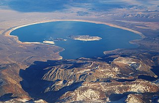
Mono Lake is a saline soda lake in Mono County, California, formed at least 760,000 years ago as a terminal lake in an endorheic basin. The lack of an outlet causes high levels of salts to accumulate in the lake which make its water alkaline.

Mono County is a county located in the east central portion of the U.S. state of California. As of the 2010 census, the population was 14,202. making it the fifth-least populous county in California. The county seat is Bridgeport. The county is located east of the Sierra Nevada between Yosemite National Park and Nevada. The only incorporated town in the county is Mammoth Lakes, which is located at the foot of Mammoth Mountain. Other locations, such as June Lake, are also famous as skiing and fishing resorts. Located in the middle of the county is Mono Lake, a vital habitat for millions of migratory and nesting birds. The lake is located in a wild natural setting, with pinnacles of tufa arising out of the salty and alkaline lake. Also located in Mono County is Bodie, the official state gold rush ghost town, which is now a California State Historic Park.
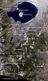
The Mono–Inyo Craters are a volcanic chain of craters, domes and lava flows in Mono County, Eastern California. The chain stretches 25 miles (40 km) from the northwest shore of Mono Lake to the south of Mammoth Mountain. The Mono Lake Volcanic Field forms the northernmost part of the chain and consists of two volcanic islands in the lake and one cinder cone volcano on its northwest shore. Most of the Mono Craters, which make up the bulk of the northern part of the Mono–Inyo chain, are phreatic volcanoes that have since been either plugged or over-topped by rhyolite domes and lava flows. The Inyo volcanic chain form much of the southern part of the chain and consist of phreatic explosion pits, and rhyolitic lava flows and domes. The southernmost part of the chain consists of fumaroles and explosion pits on Mammoth Mountain and a set of cinder cones south of the mountain; the latter are called the Red Cones.

Bodie is a ghost town in the Bodie Hills east of the Sierra Nevada mountain range in Mono County, California, United States. It is about 75 miles (121 km) southeast of Lake Tahoe, and 12 mi (19 km) east-southeast of Bridgeport, at an elevation of 8,379 feet (2554 m). Bodie became a boom town in 1876 after the discovery of a profitable line of gold; by 1879 it had a population of 7,000–10,000.
U.S. Route 6 (US 6), also called the Grand Army of the Republic Highway, honoring the American Civil War veterans association, is a main route of the U.S. Highway system. While it currently runs east-northeast from Bishop, California, to Provincetown, Massachusetts, the route has been modified several times. The highway's longest-lasting routing, from 1936 to 1964, had its western terminus at Long Beach, California. During this time, US 6 was the longest highway in the country.
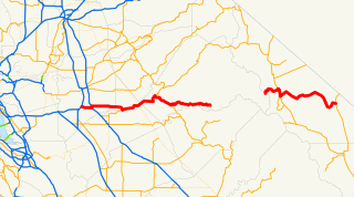
State Route 120 is a state highway in the U.S. state of California, running west to east across the central part of the state. It runs from Interstate 5 in Lathrop in the San Joaquin Valley through Yosemite National Park, to its end at U.S. Route 6 in Mono County, in eastern California. While the route is signed as a contiguous route through Yosemite National Park, the portion in park boundaries is federally maintained, and is not included in the state route logs. The portion at Tioga Pass is the highest paved through road in the California State Route system. This part is not maintained in the winter and is usually closed during the winter season.
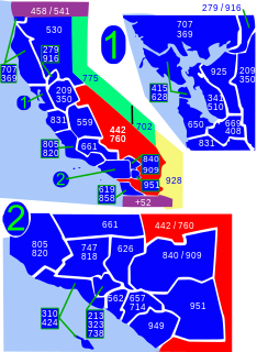
Area code 760 is a California telephone area code that was split from area code 619 on March 22, 1997. Area code 442 is an overlay of 760 that became effective on November 21, 2009. It encompasses much of the southeastern and southernmost portions of California. The area includes Imperial, Inyo, and Mono counties, as well as portions of San Diego, Riverside, San Bernardino, Los Angeles and Kern counties.

Lee Vining is a census-designated place in Mono County, California, United States. It is located 21 miles (34 km) south-southeast of Bridgeport, at an elevation of 6781 feet. Lee Vining is located on the southwest shore of Mono Lake. The population was 222 as of the 2010 census, down from 250 reported as of 2000 by Mono County. At the previous census (1990) the town population was 398, and at the census before that (1980) it was 315.
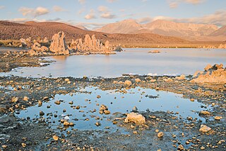
Mono Lake Tufa State Natural Reserve is located near Yosemite National Park within Mono County, in eastern California. It was established in 1981 by the California State Legislature to preserve the natural limestone "tufa tower" formations at Mono Lake.
New York State Route 55 (NY 55) is a 122.45-mile-long (197.06 km) east-west state highway in southern New York, running from the Pennsylvania state line at the Delaware River in Barryville to the Connecticut state line at Wingdale. It is the only other state highway beside NY 7 to completely cross the state, from border to border, in an east–west direction, although NY 17 does so and is partially east–west. It also forms a concurrency when it joins US 44 for 33 miles (53 km).
New York State Route 120 (NY 120) is a state highway in southern Westchester County, New York, in the United States. It begins in the city of Rye at an intersection with U.S. Route 1 (US 1) and runs for about 18 miles (29 km) north to the hamlet of Millwood, where it ends at a junction with NY 100. The route intersects with several limited-access highways, including Interstate 684 (I-684) and the Saw Mill River Parkway, and serves the Westchester County Airport in North Castle. Portions of the route have been signed ceremonially in remembrance of American serviceman killed in the 2000s and 2010s during the wars in Iraq and Afghanistan.
New York State Route 14A (NY 14A) is a north–south state highway located in the Finger Lakes region of New York in the United States. It extends for 35.99 miles (57.92 km) from an interchange with NY 14 in the Schuyler County town of Reading to an intersection with U.S. Route 20 (US 20) and NY 5 west of the Ontario County city of Geneva. In between, the two-lane route serves Yates County and the village of Penn Yan, located at the northeastern tip of Keuka Lake. Outside of Penn Yan, NY 14A traverses rural, rolling terrain dominated by farmland.

Lundy is a defunct community in Mono County, California, United States, located on Mill Creek in Lundy Canyon near the west end of Lundy Lake. It is situated at an elevation of 7858 feet. It was named after W.J. Lundy who operated a sawmill near Lundy Lake. The sawmill was a major timber producer for the nearby town of Bodie, California. Lundy also had a mining camp that was established in 1879. The Lundy post office ran from 1880 to 1914.
U.S. Route 395 (US 395) is a United States Numbered Highway, stretching from Hesperia, California to the Canadian border in Laurier, Washington. The California portion of US 395 is a 557-mile (896 km) route which traverses from Interstate 15 (I-15) in Hesperia, north to the Oregon state line in Modoc County near Goose Lake. The route clips into Nevada, serving the cities Carson City and Reno, before returning to California.

The Bodie & Benton Railway was a 3 ft narrow gauge common carrier railroad in California, from the Mono Mills to a terminus in Bodie, now a ghost town, in Mono County. It was unusual among U.S. railroads in that it was completely isolated from the rest of the railroad system.

Benton is a census-designated place in Mono County, California, United States. It is located 3 miles (4.8 km) east-northeast of the community of Benton Hot Springs and 32 miles (51 km) north of the community of Bishop, at an elevation of 5387 feet. The population was 280 at the 2010 census, up from 196 reported at 2000 by Mono County.
Highway 94 is an east–west state highway in Benton County, Arkansas. The route of 22.07 miles (35.52 km) runs from Horseshoe Bend Park near Beaver Lake west across US Route 71 Business (US 71B) and US 62 to Missouri Supplemental Route E at the Missouri state line. The route is maintained by the Arkansas State Highway and Transportation Department (AHTD).
Mono Mills is a ghost town in Mono County, California. It is located 9.5 miles (15 km) east-southeast of Lee Vining, at an elevation of 7356 feet. Mono Mills has nearly vanished. Its site is along California State Route 120, 9.1 miles (15 km) east from the junction with U.S. Route 395.

The Mono Basin National Forest Scenic Area is a protected area in Eastern California that surrounds Mono Lake and the northern half of the Mono Craters volcanic field. It is administered by the Inyo National Forest as a unit of the National Forest Scenic Area program, under the U.S. Forest Service.

Lake Russell is a former lake stage of Mono Lake. It was named in honour of Israel Russell, but is also known as Lake Mono in contrast to the present-day lake. This lake was larger than present-day Mono Lake and occasionally overflowed first into the East Walker River and later into the Owens River. During its existence, glaciers from the Sierra Nevada reached until its shore.
