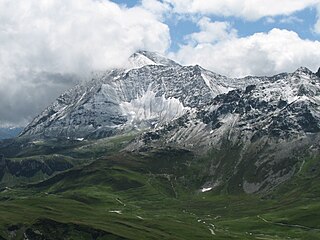
Mount Caubvick is a mountain located in Canada on the border between Labrador and Quebec in the Selamiut Range of the Torngat Mountains. Mount Caubvick is the highest point in mainland Canada east of the Rockies. The mountain contains a massive peak that rises sharply from nearby sea level. Craggy ridges, steep cirques and glaciers are prominent features of the peak.

The Chic-Choc Mountains, also spelled Shick Shocks, is a mountain range in the central region of the Gaspé Peninsula in Quebec, Canada. It is a part of the Notre Dame Mountains, which is a continuation of the Appalachian Mountains.

Sandy Bay Mountain, known officially in Quebec as Mont Sandy Stream, is a mountain located on the Canada–United States border, with a height of 950 m (3,117 ft) above sea level. The northeastern part of the mountain is in Somerset County, Maine, while the southwestern part is in Saint-Ludger, Quebec. There, it is unofficially known as Mont Bélanger.

Mont Blanc du Tacul is a mountain in the Mont Blanc massif of the French Alps situated midway between the Aiguille du Midi and Mont Blanc.

Mont Blanc de Courmayeur is a point on the south-east ridge of Mont Blanc that forms the peak of the massive south-east face of the mountain. It is connected to the main summit via the Col Major.

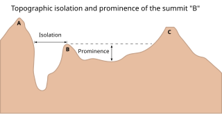
The topographic isolation of a summit is the minimum distance to a point of equal elevation, representing a radius of dominance in which the peak is the highest point. It can be calculated for small hills and islands as well as for major mountain peaks, and can even be calculated for submarine summits.

This article comprises three sortable tables of major mountain peaks of Canada.

Mont Mégantic is a monadnock located in Québec, Canada, about 15 km north of the border between Québec and the U.S. states of Maine and New Hampshire. Mégantic is on the border of the regional county municipalities of Le Granit and Le Haut-Saint-François. Its summit is the highest point of the latter. Many geologists believe that Mont Mégantic is a member of the Monteregian Hills formed by the New England hotspot, as it has the same mechanism and depth of intrusion.

The Grand Pilier d'Angle is a buttress on the southern side of Mont Blanc in the Mont Blanc massif in the Aosta Valley, Italy.

Lac-Alfred is an unorganized territory in the Bas-Saint-Laurent region of Quebec, Canada.

Mont Chapman is the highest peak in the Stoke Mountains of the southern Notre Dame mountain range located in Stoke, Quebec, Canada. It is accessible from trails maintained by Les Sentiers de l'Estrie. From the summit, one is able to see Mont Ham, Mont Ste-Cécile, and Mont Mégantic. Neighboring Bald Peak is accessible by these same trails.

Mont Ham is a mountain in the southern Notre Dame Mountains in Quebec, Canada. Its primary summit lies at an elevation of 713 m, with a prominence of 358 m. Marked trails on the mountain permit visitors a 360 degree view of the surrounding landscape. The park in which it is situated is open year-round and offers hiking, scrambling, snowshoeing, cross-country skiing, disc golf, and camping. In 2014, the park became the first in the Eastern Townships to gain "regional park" status, along with a $1,367,250 grant for expansion and improvements.

Mount Hereford is a mountain located in Coaticook Regional County Municipality, Estrie, Quebec, Canada. It rises to 864 metres (2,835 ft).

The Punta Merciantaira or Grand Glaiza is a 3,293 metres high mountain of the Cottian Alps.

The Beaufortain Massif is a massif of the French Alps that straddles the departments of Savoie and Haute-Savoie, in the historical region of Savoy.


