
Mont Blanc is the highest mountain in the Alps and Western Europe, and the highest mountain in Europe outside the Caucasus mountains, rising 4,805.59 m (15,766 ft) above sea level, located on the French-Italian border. It is the second-most prominent mountain in Europe, after Mount Elbrus, and the 11th most prominent mountain summit in the world.
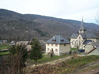
Montmin is a former commune in the Haute-Savoie department in the Auvergne-Rhône-Alpes region in south-eastern France. On 1 January 2016, it was merged into the new commune of Talloires-Montmin.
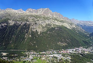
Argentière is a picturesque skiing, alpine walking and mountaineering village in the French Alps, part of the commune of Chamonix-Mont-Blanc, at an altitude of 1,252 m (4,108 ft).

Federico Martín Bahamontes, born Alejandro Martín Bahamontes, was a Spanish professional road racing cyclist. He won the 1959 Tour de France and a total of 11 Grand Tour stages between 1954 and 1965. He won a total of nine mountain classifications and was the first cyclist to complete a "career triple" by winning the mountain classification in all three Grand Tours. Following his retirement, Bahamontes ran a bicycle and motorcycle shop and was named the best climber in the history of the Tour de France by a panel organised by L'Équipe in 2013.
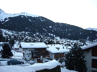
Verbier is a village located in south-western Switzerland in the canton of Valais. It is a holiday resort and ski area in the Swiss Alps and is recognised as one of the premier off-piste resorts in the world. Some areas are covered with snow all year. Skiers have settled in the Verbier area in order to take advantage of the steep slopes, varied conditions, and resort culture.
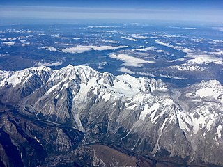
The Mont Blanc massif is a mountain range in the Alps, located mostly in France and Italy, but also straddling Switzerland at its northeastern end. It contains eleven major independent summits, each over 4,000 metres (13,123 ft) in height. It is named after Mont Blanc, the highest point in western Europe and the European Union. Because of its considerable overall altitude, a large proportion of the massif is covered by glaciers, which include the Mer de Glace and the Miage Glacier – the longest glaciers in France and Italy, respectively.

Col de la Forclaz is a mountain pass in the Alps in the Canton of Valais in Switzerland. It connects Martigny at 471 m (1,545 ft) and Le Châtelard (Finhaut). The road from Martigny to the Col has an average gradient of 6% but in parts is closer to 8%. After the Col, and Le Châtelard, the road leads to Chamonix in France via Vallorcine and the Col des Montets.

Col des Montets is a mountain pass in the French Alps in the Haute-Savoie department of France. It is on the road between Chamonix, the Swiss Col de la Forclaz and Martigny in the canton of Valais, Switzerland.
Les-Praz-de-Chamonix is a mountain village in the French Alps, part of the commune of Chamonix. Altitude: 1060 m (3477 ft.).
The Time-Megeve-Mont-Blanc is a cyclosportive that takes place early June in the northern part of the French Alps, 45 km from Geneva. This cycling event attracts 2,000 riders on a 140-km route that starts from the valley town of Sallanches and includes three passes: Col de la Colombiere, Col des Aravis, and Col des Saisies. The event finishes in the ski resort of Megève.
Saint-Jean-de-Couz is a commune in the Savoie department in the Auvergne-Rhône-Alpes region in south-eastern France.
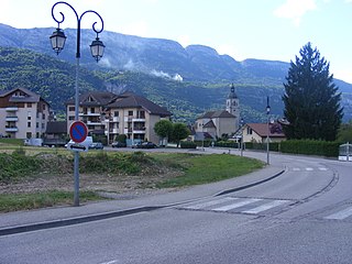
Doussard is a commune in the southeastern French department of Haute-Savoie.
The Pointe Ronde is a mountain of the Mont Blanc massif, overlooking Trient in the canton of Valais. It lies near the northern end of the Arête de la Lys, the ridge descending in a north-westerly direction from the Génépi towards the Col de la Forclaz.

The Grand Darray is a mountain of the Mont Blanc massif, located north of La Fouly in the canton of Valais. It lies on the range east of the Aiguille de l'A Neuve, between the Saleina Glacier and the main Ferret valley.

Val Ferret is the name shared by two valleys separated by the Col Ferret, a pass on the border between Italy and Switzerland. The valleys lie southeast of Mont Blanc Massif. The Swiss valley drains northeast towards Orsières and on into the Rhône basin; whereas the Italian valley drains southwest towards Courmayeur and on into the Po basin.

Mont Tendre is a mountain of the Jura, located between the valley of Joux and the basin of Lake Geneva in the canton of Vaud. With an elevation of 1,679 metres above sea level, it is the highest summit of the Swiss portion of the Jura Mountains and, therefore, the highest summit of Switzerland outside the Alps. It is also the most isolated mountain of the canton. It is found in the community of Montricher.
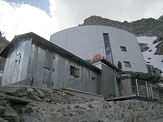
The Gonella Hut is a high elevation mountain hut in the Aosta Valley in the Mont Blanc massif area of the Alps. It lies at an elevation of 3071 metres, above Val Veny near Courmayeur in Italy. The refuge is located on the Italian 'normal route' to Mont Blanc.
The Couronne de Bréona, 3,159 m (10,364 ft) is a mountain of the Pennine Alps, located east of Les Haudères in the canton of Valais. It lies north of the Tsa de l'Ano, on the range between the valleys of Hérens and Moiry.

The 2016 Tour de France was the 103rd edition of the cycle race, one of cycling's Grand Tours. On 24 November 2014 Amaury Sport Organisation announced that the race will depart, on 2 July 2016, from the French department of Manche, for the first time in the history of the Tour de France. The race had a stage finish in Andorra. The race finished on the Champs-Élysées in Paris on 24 July.

