Montau (mountain)

Last updated
Montau
Catalonia location map.svg
Red triangle with thick white border.svg
Montau
Catalonia, Spain
Highest point
Elevation 657.1 m (2,156 ft)
Coordinates 41°20′45.07″N1°53′06.048″E / 41.3458528°N 1.88501333°E / 41.3458528; 1.88501333 Coordinates: 41°20′45.07″N1°53′06.048″E / 41.3458528°N 1.88501333°E / 41.3458528; 1.88501333
Geography
Location Alt Penedès, Baix Llobregat, Catalonia
Parent range Garraf Massif
(Catalan Coastal Range)
Geology
Mountain type Karstic
Climbing
First ascent Unknown
Easiest route From Olesa de Bonesvalls

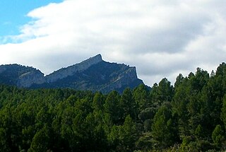
Montau is a mountain located in the municipal terms of Olesa de Bonesvalls (Alt Penedès) and Begues (Baix Llobregat), Catalonia, Spain. It has an elevation of 657 metres above sea level. [1]

Olesa de Bonesvalls Municipality in Catalonia, Spain

Olesa de Bonesvalls is a village and municipality in the Alt Penedès comarca in Catalonia, Spain. Until 1990 it was included in Garraf comarca.

Alt Penedès Comarca in Catalonia, Spain

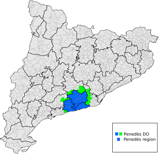
Alt Penedès is a comarca (county) in Catalonia, northern Spain. The capital is Vilafranca del Penedès.

Begues Municipality in Catalonia, Spain

Begues is a municipality in the comarca of Baix Llobregat in Catalonia, Spain. It is situated in the south-west of the comarca, and its municipal territory covers most of the Garraf massif including the peaks of el Montau (658 m) and La Morella (594 m).

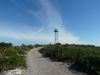
It is the highest point of the Garraf Massif, Catalan Coastal Range, although less conspicuous than La Morella, located closer to the coast. There is a triangulation station at the summit.

Garraf Massif mountain range

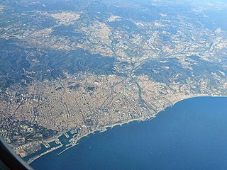
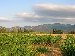
The Garraf Massif is a mountain range of the Catalan Coastal Range, Catalonia, Spain. Its cliffs reach the Mediterranean waters. Its highest point on the coastal side is La Morella, 593 metres above sea level and further inland rises the higher, although less conspicuous, Montau.

Catalan Coastal Range

The Catalan Coastal Range is a system of mountain ranges running parallel to the Mediterranean Sea coast in Catalonia, Spain. It is part of the Catalan Mediterranean System. Its main axis runs between the Foix River and the Roses Gulf and the average altitude is around 500 m. The highest point is 763 m at the Montnegre.

La Morella mountain in Spain

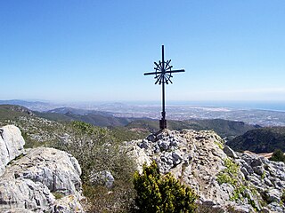
La Morella or Morella is a mountain located in Begues municipality, Catalonia, Spain. It has an elevation of 593 metres above sea level.

See also

Related Research Articles

Sitges Municipality in Catalonia, Spain

Sitges is a town about 35 kilometres southwest of Barcelona, in Catalonia, renowned worldwide for its Film Festival and Carnival. Located between the Garraf Massif and the sea, it is known for its beaches, nightspots, and historical sites.

Province of Barcelona Province of Spain

Barcelona is a province of eastern Spain, in the center of the autonomous community of Catalonia. The province is bordered by the provinces of Tarragona, Lleida, and Girona, and by the Mediterranean Sea. Its area is 7,726 km2 (2,983 sq mi). 5,609,350 people live in the province, of whom about 30% (1,620,343) live within the administrative limits of the city of Barcelona, which itself is contained in the Barcelona metropolitan area.

Sant Pere de Ribes Municipality in Catalonia, Spain

Sant Pere de Ribes is a town in the center of the Garraf comarca, in Barcelona province, Catalonia, Spain. The remains of a 12th-century castle once ruled by the troubadour Guillem de Ribes are in the town.

Olivella Municipality in Catalonia, Spain

Olivella is a municipality in Catalonia, in the province of Barcelona, Spain. It is situated in the comarca of Garraf.

Olèrdola Municipality in Catalonia, Spain

Olèrdola is a municipality in the comarca of the Alt Penedès in Catalonia, Spain. It is situated on the northern side of the Garraf massif, and the highest point of the municipality is the Puig de l'Àliga at 468 m.

C-31 highway (Spain)

C-31 or Eix Costaner is a Catalonia's primary highway. It is the result of merging several sections of previously existing roads, autopistas and autovías after the 2004's renaming of primary highways managed by the Generalitat de Catalunya. According to this new denomination, the first number (C-31) indicates that is a southwest-northeast highway, while the second number (C-31) indicates that is the closest to the Mediterranean Sea.

Penedès natural and historical region of the autonomous community of Catalonia, Spain

Penedès is a natural and historical region of the autonomous community of Catalonia, Spain. It is located in the south of the Principality of Catalonia between the pre-coastal mountain range and the Mediterranean Sea. The comarcal division of the Generalitat de Catalunya in 1936 and 1987, divided Penedès into three administrative comarques: Alt Penedès, Baix Penedès and Garraf, and their capitals are Vilafranca del Penedès, el Vendrell and Vilanova i la Geltrú.

Canyelles (town) Municipality in Catalonia, Spain

Canyelles is a town in the northeast of the Garraf comarca (county) in the south of Barcelona province, Catalonia, Spain. It is home to a 15th-century castle.

Garraf (Sitges) Village in Catalonia, Spain

Garraf is a small seaside village located between Sitges and Castelldefels, in the Garraf comarca, Catalonia, Spain, surrounded by the area of the Garraf Natural Park.

Tossal dels Tres Reis mountain in Spain

Tossal dels Tres Reis or Tossal del Rei is a mountain of the Ports de Tortosa-Beseit massif, Spain. It has an elevation of 1,350 metres above sea level.

Puig de la Mola mountain in Spain

Puig de la Mola is a mountain in the Garraf Massif, Catalonia, Spain. It has an elevation of 533 metres above sea level.

Serra de Paüls mountain in Spain

Serra de Paüls is a mountain range in the northern side of the Ports de Tortosa-Beseit, Catalonia, Spain. The highest summit, Punta de l'Aigua has an elevation of 1,091.6 metres above sea level.

Sant Llorenç del Munt mountain

Sant Llorenç del Munt is a largely rocky mountain massif in central Catalonia, Spain. The highest summit, where the Monestir de Sant Llorenç del Munt is located, has an elevation of 1,104.2 metres (3,623 ft) above sea level and is known as La Mola. Montcau 1,056.8 metres (3,467 ft) is another important peak of the massif. On the massif, there is a protected area under the name Parc Natural de Sant Llorenç del Munt i l'Obac.

Albera Massif mountain range

The Albera Massif is a mountain range located in the south of Pyrénées-Orientales and the north of Catalonia, between France and Spain. It is the main easternmost prolongation of the Pyrenees. Its highest peak is the Puig Neulós, with an elevation of 1,256 metres.

Besiberri Massif mountain in Spain

Besiberri Massif is a mountain massif of the central area of the Pyrenees, Lleida, Catalonia, Spain. It is located at the western limit of the Aigüestortes i Estany de Sant Maurici National Park.

References

  1. "Mapa Topogràfic de Catalunya". Institut Cartogràfic de Catalunya. Retrieved May 22, 2010..