
Zaculeu or Saqulew is a pre-Columbian Maya archaeological site in the highlands of western Guatemala, about 3.7 kilometres (2.3 mi) outside the modern city of Huehuetenango. Occupation at the site dates to the Early Classic period (AD 250–600) of Mesoamerican history. Zaculeu was the capital of the Postclassic Mam kingdom, and was conquered by the K'iche' Kingdom of Q'umarkaj. It displays a mixture of Mam and K'iche' style architecture.

Monte Albán is a large pre-Columbian archaeological site in the Santa Cruz Xoxocotlán Municipality in the southern Mexican state of Oaxaca. The site is located on a low mountainous range rising above the plain in the central section of the Valley of Oaxaca, where the latter's northern Etla, eastern Tlacolula, and southern Zimatlán and Ocotlán branches meet. The present-day state capital Oaxaca City is located approximately 9 km (6 mi) east of Monte Albán.
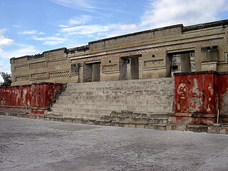
Mitla is the second-most important archeological site in the state of Oaxaca in Mexico, and the most important of the Zapotec culture. The site is located 44 km from the city of Oaxaca, in the upper end of the Tlacolula Valley, one of the three cold, high valleys that form the Central Valleys Region of the state. At an elevation of 4,855 ft, surrounded by the mountains of the Sierra Madre del Sur, the archeological site is within the modern municipality of San Pablo Villa de Mitla. It is 24 mi (38 km) southeast of Oaxaca city. While Monte Albán was the most important politically of the Zapotec centers, Mitla became the main religious one in a later period as the area became dominated by the Mixtec.

Mesoamerican pyramids form a prominent part of ancient Mesoamerican architecture. Although similar in some ways to Egyptian pyramids, these New World structures have flat tops and stairs ascending their faces. The largest pyramid in the world by volume is the Great Pyramid of Cholula, in the east-central Mexican state of Puebla. The builders of certain classic Mesoamerican pyramids have decorated them copiously with stories about the Hero Twins, the feathered serpent Quetzalcoatl, Mesoamerican creation myths, ritualistic sacrifice, etc. written in the form of hieroglyphs on the rises of the steps of the pyramids, on the walls, and on the sculptures contained within.

Tilantongo was a Mixtec citystate in the Mixteca Alta region of the modern-day state of Oaxaca which is now visible as an archeological site and a modern town of Santiago Tilantongo. It is located at 17°15' N. Lat. and 97°17' W. Long. Its Mixtec name was Ñuu Tnoo-Huahi Andehui meaning Black Town-Temple of Heaven

Heroica Ciudad de Huajuapan de León[waˈxwapan de leˈon] is a city with a surrounding municipality located in the northwestern part of the Mexican state of Oaxaca. It is part of the Huajuapan District in the north of the Mixteca Region. It has a population of about 45,321, the sixth-largest community in the state in population. It is located at the intersection of Federal Highways 125 and 190. The name of Huajuapan comes from the Nahuatl words huaxin = huaje, ohtli = road, and apan = river. Literally, River of the huajes. The town was elevated to an honorary Mexican status in June 1843 in remembrance of The siege of Huajuapan, a battle between the royal army and the insurgents led by José María Morelos. The battle was won by the insurgents. The city was named after Antonio de León, a hero of the Mexican War of Independence.

The Zapotec civilization was an indigenous pre-Columbian civilization that flourished in the Valley of Oaxaca in Mesoamerica. Archaeological evidence shows that their culture originated at least 2,500 years ago. The Zapotec archaeological site at the ancient city of Monte Albán has monumental buildings, ball courts, magnificent tombs and grave goods, including finely worked gold jewelry. Monte Albán was one of the first major cities in Mesoamerica. It was the center of a Zapotec state that dominated much of the territory which today is known as the Mexican state of Oaxaca.

The Central Valleys of Oaxaca, also simply known as the Oaxaca Valley, is a geographic region located within the modern-day state of Oaxaca in southern Mexico. In an administrative context, it has been defined as comprising the districts of Etla, Centro, Zaachila, Zimatlán, Ocotlán, Tlacolula and Ejutla. The valley, which is located within the Sierra Madre Mountains, is shaped like a distorted and almost upside-down “Y,” with each of its arms bearing specific names: the northwestern Etla arm, the central southern Valle Grande, and the Tlacolula arm to the east. The Oaxaca Valley was home to the Zapotec civilization, one of the earliest complex societies in Mesoamerica, and the later Mixtec culture. A number of important and well-known archaeological sites are found in the Oaxaca Valley, including Monte Albán, Mitla, San José Mogote and Yagul. Today, the capital of the state, Oaxaca City, is located in the central portion of the valley.

The Zapotec script is the writing system of the Zapotec culture and represents one of the earliest writing systems in Mesoamerica. Rising in the late Pre-Classic era after the decline of the Olmec civilization, the Zapotecs of present-day Oaxaca built an empire around Monte Albán. One characteristic of Monte Albán is the large number of carved stone monuments one encounters throughout the plaza. There and at other sites, archaeologists have found extended text in a glyphic script.

Yucuita is an archaeological site located in the Mixtec municipality of San Juan Yucuita in the Mexican state of Oaxaca. It was founded by the Mixtec civilization in the pre-Classic Period as a small village dedicated to agriculture and obsidian.
Guiengola is a Zapotec archeological site located 14 km (8.7 mi) north of Tehuantepec, and 243 km (151 mi) southeast of Oaxaca city on Federal Highway 190. The visible ruins are located between a hill and a river, each carries the name of Guiengola. The name means "large stone" in the local variant of the Zapotec language. There are two main tombs that have been excavated, and both seem to be family interment sites. Both have front chambers that are for religious idols, while the rear chambers are for the burial of important people. The site also has fortified walls, houses, ballgame fields, other tombs and a very large "palace" with remains of artificial ponds and terraces. In the center of the site are 2 plazas, one lower than the other, and 2 pyramids, one to the east and one to the west.

Yagul is an archaeological site and former city-state associated with the Zapotec civilization of pre-Columbian Mesoamerica, located in the Mexican state of Oaxaca. The site was declared one of the country's four Natural Monuments on 13 October 1998. The site is also known locally as Pueblo Viejo and was occupied at the time of the Spanish Conquest. After the Conquest the population was relocated to the nearby modern town of Tlacolula where their descendants still live.
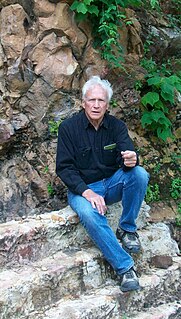
Ronald M. Spores is an American academic anthropologist, archaeologist and ethnohistorian, whose research career has centered on the pre-Columbian cultures of Mesoamerica. He is Professor Emeritus of anthropology at Vanderbilt University's College of Arts and Science, where he has been a faculty member for over four decades. Spores is most renowned for his scholarship conducted on the cultural history of the Oaxacan region in southwestern Mexico. In particular, he has made many contributions on the Mixtec culture, investigating its archaeological sites, ethnohistorical documents, political economies, and ethnohistory in both the pre-Columbian and Colonial eras. He was co-director of the Proyecto Arqueológico de la Ciudad Yucundaa Pueblo Viejo de Teposcolula, Oaxaca, sponsored by the Fundación Alfredo Harp Helu, the National Geographic Society, and INAH (2004–2010), and currently (2017) directs research on the sixteenth century Casa del Cacique de Yanhuitlan, Oaxaca, and related investigation of the surrounding Prehispanic-Colonial city and region. He is also Research Associate at the American Museum of Natural History, New York, and at the University of Oregon and investigator on the Proyecto Geoparque de la Mixteca Alta, Universidad Nacional Autónoma de México/UNESCO, centered at Yanhuitlan, Oaxaca (2016-2017). Recent research relates to the colonial Manila Galleon trade between the Philippines and Acapulco.

Lambityeco is a small archaeological site just about 3 kilometers west of the Tlacolula city in the Mexican state of Oaxaca. It is located just off Highway 190 about 25 km (16 mi) east from the city of Oaxaca en route to Mitla. The site has been securely dated to the Late Classical Period.

Dainzú is a Zapotec archaeological site located in the eastern side of the Valles Centrales de Oaxaca, about 20 km south-east of the city of Oaxaca, Oaxaca State, Mexico. It is an ancient village near to and contemporary with Monte Albán and Mitla, with an earlier development. Dainzú was first occupied 700-600 BC but the main phase of occupation dates from about 200 BC to 350 AD. The site was excavated in 1965 by Mexican archaeologist Ignacio Bernal.

Cerro de la Minas is an archaeological site located in the modern state of Oaxaca, just to the north of the city of Huajuapan de León. The site belongs to what is called the Ñuiñe, or lowland/hot lands Mixtec cultural area. The site is located on a hill that dominates the Valley of Huajuapan, in what are now the neighborhoods of Chapultepec, Santa Rosa, Alta Vista and Del Maestro of the city. This large hill is in a strategic position over the farmlands of the valley, which provided it with its food, as well as the trade routes that cross this valley, which made it regionally important. The site contains a number of settlements and was reserved for the elite of that area during that time. Cerro de las Minas is the only lowland Mixtec archeological site open to the public.
Mixteca Alta Formative Project (2003–present) is an archaeological project directed by Andrew Balkansky that focuses on the Mixtec of Oaxaca, Mexico. The project, which is funded by the National Science Foundation, the National Geographic Society, and the H. John Heinz III Fund, seeks to understand Mixtec origins and their transition to urbanism. Excavations are currently taking place at the ancient site of Tayata.

Huamelulpan is an archaeological site of the Mixtec culture, located in the town of San Martín Huamelulpan at an elevation of 2,218 metres (7,277 ft), about 96 kilometres (60 mi) north-west of the city of Oaxaca, the capital of Oaxaca state.

Chutixtiox is an archaeological site of the ancient Maya civilization near Sacapulas, in the Quiché department of modern Guatemala. The site was excavated during the 20th century by A. Ledyard Smith. Ceramic evidence excavated at the site suggests a close relationship with the K'iche' capital of Q'umarkaj. Chutixtiox may have been a settlement in a polity that included the nearby sites of Chutinamit and Xolpacol.

Cihuatán is a major pre-Columbian archaeological site in central El Salvador. It was a very large city located in the extreme south of the Mesoamerican cultural area, and has been dated to the Early Postclassic period of Mesoamerican chronology.


