
Goodnews Bay is a city in Bethel Census Area, Alaska, United States. As of the 2010 census, the population of the city was 243, up from 230 in 2000.

Verbano-Cusio-Ossola is the northernmost province in the Italian region of Piedmont. It was created in 1992 through the fusion of three geographical areas which had previously been part of the Province of Novara. The area flanking the western shore of Verbano forms the eastern part of the province; Cusio and its environs form the southern part; while the north and west of the province consist of the Ossola, a region of Alpine mountains and valleys. The ISO code for the province is VB.
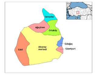
Ağaçören, formerly Panlı, is a town and district of Aksaray Province in the Central Anatolia region of Turkey. According to 2000 census, population of the district is 15,869 of which 4,983 live in the town of Ağaçören. The district covers an area of 395 km2 (153 sq mi), and the average elevation is 1,100 m (3,609 ft).

The Petite-Nation River is a river in western Quebec, Canada, that flows from the Laurentian Mountains to empty into the Ottawa River near Plaisance, Quebec. The river is 97 kilometres (60 mi) in length.
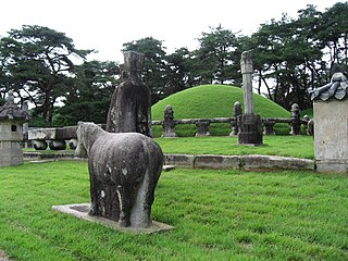
The Tombs of the Joseon dynasty refers to the 40 tombs of members of the House of Yi, which ruled Korea between 1392–1910. These tombs are scattered over 18 locations across the Korean Peninsula. They were built to honor and respect the ancestors and their achievements, and assert their royal authority. The tombs have been registered as an UNESCO World Heritage Site since 2009. Two other Joseon tombs, located in Kaesong, North Korea, were proposed but not submitted.

Kujang County is a kun, or county, in southeastern North P'yŏngan province, North Korea. It was created in 1952 from part of Nyŏngbyŏn county, as part of a nationwide reorganization of local government. It borders Nyŏngbyŏn on the west, Hyangsan and Unsan counties on the north, Nyŏngwŏn on the east, and Kaech'ŏn and Tŏkch'ŏn cities to the south.

Fatick Department is one of the 45 departments of Senegal, one of the three departments making up the Fatick Region, and lies on the road between Mbour and Kaolack. The Fatick region is home to many Sereer people; the Sereers are one of the major ethnic groups in Senegal and there are four Sereer dialects. Fatick town is the major urban center for the region.

Petersburg North No. 14 Precinct is located in Menard County, Illinois. The population was 137 at the 2000 census.
Jeanne-Mance was a former provincial electoral district in Quebec, Canada.
The Moravian Gate is a geomorphological feature in the Moravian region of the Czech Republic and the Upper Silesia region in Poland. It is formed by the depression between the Carpathian Mountains in the east and the Sudetes in the west. The drainage divide between the upper Oder river and the Baltic Sea in the north and the Bečva River of the Danube basin runs through it.
Goghtanik is a village in the Yeghegis Municipality of the Vayots Dzor Province in Armenia.
Łyszkowo is a village in the administrative district of Gmina Krasne, within Przasnysz County, Masovian Voivodeship, in east-central Poland. It lies approximately 17 kilometres (11 mi) south of Przasnysz and 73 km (45 mi) north of Warsaw.
Nowe Kębłowo is a village in the administrative district of Gmina Luzino, within Wejherowo County, Pomeranian Voivodeship, in northern Poland. It lies approximately 3 kilometres (2 mi) north of Luzino, 10 km (6 mi) west of Wejherowo, and 42 km (26 mi) north-west of the regional capital Gdańsk.
Kanaka Creek Regional Park is a regional park of the Greater Vancouver Regional District, located in the city of Maple Ridge, British Columbia, flanking both sides of Kanaka Creek from its confluence with the Fraser River just east of Haney and extending approximately 11 km up the creek to just south of the community of Webster's Corners.

Westcock is a Canadian rural community in Westmorland County, about eight kilometres southwest of Sackville. In 1866, Westcock was a farming and lumbering settlement with about 62 families, while in 1898, Westcock had 1 post office, 1 sawmill, 1 grist mill, 1 church and a population of 150.

Butyrsky District is an administrative district (raion) of North-Eastern Administrative Okrug, and one of the 125 raions of Moscow, Russia. It is 6 km north of the Moscow city center, located just outside the third ring road, with Timiryazevsky District to the west and Marfino District and Maryina roshcha District to the east. The area of the district is 5.04 square kilometers (1.95 sq mi). Population: 68,700.

Pilat Regional Natural Park is a protected area of mountainous countryside in the Auvergne-Rhône-Alpes region of southeastern France. The park spans the departments of Loire and Rhône, and covers a total area of 65,000 hectares.

The First Battle of Monte Grappa, also known as First Battle of the Piave in Italy, was a battle fought during World War I between the armies of the Austro-Hungarian Empire and the Kingdom of Italy for control of the Monte Grappa massif, which covered the left flank of the new Italian Piave front.

Rue Sainte-Anne is a street in the 1st and 2nd arrondissement of Paris.

Anton Mollinary Freiherr von Monte Pastello was an Austro-Hungarian General of the Artillery and writer. He was known for being the Deputy of the 4th Corps during the Battle of Königgrätz and had an extensive campaign within mid 19th-century conflicts involving Austria.
