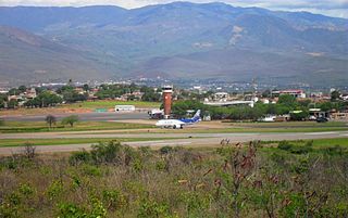
Montelíbano Airport

Last updated
Montelíbano Airport
Summary
Airport type Public
Serves Montelíbano, Colombia
Elevation  AMSL 160 ft / 49 m
Coordinates 7°58′20″N75°25′58″W / 7.97222°N 75.43278°W / 7.97222; -75.43278 Coordinates: 7°58′20″N75°25′58″W / 7.97222°N 75.43278°W / 7.97222; -75.43278
Map
Colombia location map.svg
Airplane silhouette.svg
MTB
Location of the airport in Colombia
Runways
Direction Length Surface
m ft
13/31 1,100 3,609 Asphalt
Source: GCM [1] Google Maps [2]

Montelíbano Airport( IATA : MTB, ICAO : SKML) is an airport serving the city of Montelíbano in the Córdoba Department of Colombia. The airport is 1 kilometre (0.62 mi) west of the town, near a bend in the San Jorge River.

An IATA airport code, also known as an IATA location identifier, IATA station code or simply a location identifier, is a three-letter code designating many airports around the world, defined by the International Air Transport Association (IATA). The characters prominently displayed on baggage tags attached at airport check-in desks are an example of a way these codes are used.

ICAO airport code four-letter code designating many airports around the world

The ICAOairport code or location indicator is a four-letter code designating aerodromes around the world. These codes, as defined by the International Civil Aviation Organization and published in ICAO Document 7910: Location Indicators, are used by air traffic control and airline operations such as flight planning.

Montelíbano Municipality and town in Córdoba Department, Colombia

Montelíbano is a town and municipality located in the Córdoba Department of Colombia. It is the seat of the Roman Catholic Diocese of Montelíbano.

Contents

The Montelibano non-directional beacon (Ident: MLB) is 3.2 nautical miles (5.9 km; 3.7 mi) northeast of the airport. [3]

Non-directional beacon radio transmitter which emits radio waves in all directions

A non-directional (radio) beacon (NDB) is a radio transmitter at a known location, used as an aviation or marine navigational aid. As the name implies, the signal transmitted does not include inherent directional information, in contrast to other navigational aids such as low frequency radio range, VHF omnidirectional range (VOR) and TACAN. NDB signals follow the curvature of the Earth, so they can be received at much greater distances at lower altitudes, a major advantage over VOR. However, NDB signals are also affected more by atmospheric conditions, mountainous terrain, coastal refraction and electrical storms, particularly at long range.

See also

Transport in Colombia

Transport in Colombia is regulated by the Ministry of Transport.

Related Research Articles

El Edén International Airport airport in La Tebaida, Quindío, Colombia

El Edén International Airport is an international airport serving Armenia, the capital of the Quindío Department of Colombia. The airport is 13 kilometres (8.1 mi) southwest of Armenia, near the town of La Tebaida. It handles domestic flights to Bogotá and Medellín and international flights to Panama City and Fort Lauderdale, Florida.

Camilo Daza International Airport airport in Colombia

Camilo Daza International Airport is a civil airport located in Cúcuta, Colombia. The airport serves the Norte de Santander Department. It is named after Colombian aviation pioneer Camilo Daza.

La Nubia Airport airport in Manizales, Colombia

La Nubia Airport is an airport serving Manizales, Colombia, 8 kilometres (5 mi) southeast of the city's downtown.

Santiago Pérez Quiroz Airport airport in Colombia

Santiago Pérez Quiroz Airport (Spanish: Aeropuerto Santiago Pérez Quiroz is an airport serving Arauca, the capital of the Arauca Department in Colombia. The runway is southeast of the city, and 2 kilometres south of Colombia's border with Venezuela.

Guaymaral Airport airport in Colombia

Guaymaral Airport is a high-elevation airport in the north of Bogotá, Colombia, also serving the towns of Cota and Chía. The runway is 15 kilometres (9.3 mi) northeast of Bogota's El Dorado International Airport.

Antonio Nariño Airport colombian airport

Antonio Nariño Airport is located in the town of Chachagüí and serves the city of Pasto in the Nariño Department of Colombia. The airport is 35 kilometres (22 mi) north of Pasto. It handles only domestic flights in addition to military operations and private charters. A new terminal, administrative and tower control are being built, also new navigation equipment is being set up due to the increasing number of passengers and cargo flights.

San Luis Airport (Colombia) airport

San Luis Airport is a high-elevation airport serving Ipiales, a city in the Nariño Department of Colombia. The airport is 4 kilometres (2.5 mi) north of the city.

Yariguíes Airport airport in Barrancabermeja, Colombia

Yariguíes Airport is an airport serving Barrancabermeja, a city in the Santander Department of Colombia. The airport is 6 kilometres (3.7 mi) southeast of the city.

Perales Airport airport in Ibagué, Colombia

Perales Airport is an airport serving the city of Ibagué in the Tolima Department of Colombia.

Antonio Roldán Betancourt Airport airport in Colombia

Antonio Roldán Betancourt Airport is an airport serving Apartadó, a town in the Antioquia Department of Colombia. The airport is in the countryside 12 kilometres (7.5 mi) southwest of Apartadó.

Gerardo Tobar López Airport airport in Colombia

Gerardo Tobar López Airport is an airport serving the Pacific coastal port of Buenaventura in the Valle del Cauca Department of Colombia. The runway is 6 kilometres (3.7 mi) south of the city.

Germán Olano Airport airport

Germán Olano Airport is an airport serving Puerto Carreño, the capital of Vichada Department in Colombia. It is also known as Puerto Carreño Airport. The airport is 1.5 kilometres (0.93 mi) west of and parallels the Orinoco River, locally Colombia's border with Venezuela.

César Gaviria Trujillo Airport airport

César Gaviria Trujillo Airport is an airport serving the town of Inírida in the Guainía Department of Colombia. The airport is named in honor of César Gaviria Trujillo, a former President of Colombia and Secretary General of the Organization of American States.

Eduardo Falla Solano Airport airport in Meta, Colombia

Eduardo Falla Solano Airport in Spanish: Aeropuerto Eduardo Falla Solano is a domestic airport serving the municipality of San Vicente del Caguán in the Caquetá Department of Colombia.

Juan H. White Airport airport

Caucasia Airport or Juan H. White Airport is an airport serving Caucasia, a city and municipality of the Antioquia Department in Colombia.

Aguas Claras Airport airport

Aguas Claras Airport is an airport serving Ocaña, a municipality of the Norte de Santander Department of Colombia.

Orocue Airport airport in Colombia

Orocue Airport is an airport serving Orocué, a town and municipality in the Casanare Department of Colombia. The runway is adjacent to the western edge of the town, north of the Meta River.

Tibú Airport airport in Colombia

Tibú Airport is an airport serving Tibú, a town and municipality in the Norte de Santander Department of Colombia. The runway is on the southern edge of the town. Both town and airport are on the east bank of the Caño Campo Cinco River, 7 kilometres (4.3 mi) west of the border with Venezuela.

Necoclí Airport airport in Colombia

Necoclí Airport is an airport serving the town of Necoclí in the Antioquia Department of Colombia.

Mandinga Airport airport in Colombia

Mandinga Airport is an airport serving the platinum mining town of Condoto in the Chocó Department of Colombia.

References