The Montgomery Dinghy Dawdle was an event held annually between 1985 and 2011 to promote use and awareness of the Montgomery Canal, and to highlight the road bridges which had been lowered. It involved unpowered craft such as dinghies, canoes and coracles travelling along the canal. Early events involved stopping the traffic and carrying boats over a road where a low bridge prevented using the canal. Increasing difficulty with supervising this aspect of the event led to it being held on sections that did not involve crossing roads, and so it became a social event, rather than a campaigning tool. This led the organisers, the Shropshire Union Canal Society, to cancel the event after 2011, but the Friends of the Montgomery Canal took it over, and turned it into a triathlon, with cycling, walking or running, and paddling, covering the whole length of the canal.
The Montgomery Dinghy Dawdle was first held in 1985, and was seen as a way to highlight the problem of bridges which had been lowered, thus preventing navigation, and to show the public that the canal could be used by boats. Mary Awcock, the founder of the event, stated at the time that "It is important to demonstrate that a restored canal will provide a valuable local and tourist amenity." The first event covered a stretch of canal either side of Gallowstree Bridge in Welshpool, which had been lowered and carried the A483 road over the canal. Some 30 boats took part, and when they got to the Bridge, volunteers stopped the traffic while all of the boats were carried across the road. Leaflets were given to the waiting drivers, and the event was a success, with good coverage in local newspapers and on the radio. [1]
The following three events all focused on Gallowstree Bridge or Whitehouse Bridge, dropped bridges which were either side of Welshpool. The events appeared to be having the required impact, and in late 1988, Mary Awcock announced that the fifth Dinghy Dawdle, to be held in 1989, would be the final one, as there would be no more road bridges around which boats needed to be portaged. Her optimism was caused by the fact the British Waterways Board had obtained an Act of Parliament undoing the abandonment order of 1944, and allowing them to reinstate the entire canal. Grant aid was available from the European Union, with half of the total cost of £32 million needing to be raised locally. The project had the support of Powys County Council, Montgomeryshire District Council, the Welsh Tourist Board and the Mid-Wales Development Board. [1] However, because of the amount of money involved, the approval of the Welsh Office was required, and this was refused by the Secretary of State for Wales, Peter Walker, in December 1988. [2]
The fifth Dinghy Dawdle was therefore not the last, as more campaigning was needed. Gallowstree Bridge was rebuilt to allow navigation in 1992, and was officially opened by David Suchet at the eighth rally, while Whitehouse Bridge was rebuilt in 1995, and the 1996 Dinghy Dawdle was able to pass under it with ease. With the Welshpool section making good progress by 1997, the organisers looked at holding future Dinghy Dawdles on other stretches of the canal, again with the main aim of highlighting lowered bridges, but there have been occasions when progress was celebrated. Thus the 2002 Dawdle included the reopening of Brynderwen Lock by Janet Lewis-Jones, a board member at British Waterways, and the 2003 event was held on the newly-reopened stretch of canal from Gronwen Wharf to Queen's Head. [3] The 2001 event had to be cancelled due to an epidemic of foot-and-mouth disease. [4]
The 2004 and 2005 events were held on the Welshpool section, with the aim of reminding the public that boats bring a canal back to life. A total of 65 boats took part in the 2005 Dawdle, paddling from Welshpool to Burgedin. The following year saw Lembit Öpik, the Member of Parliament for Montgomeryshire, performing an opening ceremony at Newhouse Lock, on the section to the south of the Welshpool section. The aims of the event remained the same: to demonstrate the benefits of a functioning canal, and raise awareness of the need to reinstate bridges. In 2010, there were still ten that needed raising, of which five carried the A483 over the canal. [5]
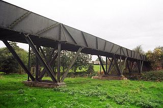
In 2011, the 26th and final Dinghy Dawdle event was held. 14 of the participants withdrew at the last minute due to inclement weather, but 29 boats took part. There had been increasing difficulty with supervising the crossing of roads in the latter years, and so the event tended to stick to sections where this was not necessary. It thus became more of a social event, rather than a campaigning tool, and so the Shropshire Union Canal Society took the decision to stop holding it. The Friends of the Montgomery Canal took it over in 2012, turning it into a triathlon with cycling, running or walking, but with paddling instead of swimming, and covering the whole length of the canal. Initially, the course involved cycling from Newtown to Welshpool, paddling from there to Llanymynech, and then walking to Frankton. [4] By 2015, the composition of the event had been changed somewhat, with the first 17 miles (27 km) from Newtown to Pool Quay completed on a bicycle, along part of the Aberystwyth to Shrewsbury cycle route. The next 10.5 miles (17 km) was completed by walking or running, and included part of Offa's Dyke as well as crossing Vyrnwy Aqueduct. The final 7.5 miles (12 km) involved paddling, with the boats being carried around the three Aston Locks and the Graham Palmer Lock, which commemorates Graham Palmer, one of the founders of the Waterway Recovery Group. There were over 230 participants for the 2015 event, with 170 covering the full distance of 35 miles (56 km). [6]
The use of small boats to highlight the plight of the canal was not new when the first Dinghy Dawdle was held. The canal had been officially abandoned by an Act of Abandonment obtained by the London, Midland and Scottish Railway in 1944, although it had effectively been closed since 1936, when a breach occurred near Frankton Junction, which was never repaired. [7] However, a trip along the whole canal was organised by Bill Thisthlewaite just after the end of the Second World War. He was a member of the fledgling Inland Waterways Association, and two boats took part, travelling along the Llangollen Canal and obtaining a toll ticket for the Montgomery section at Ellesmere, despite the fact that the canal was officially derelict. A horse and cart were used to carry the boats around the breached section. [1]
Subsequently, there were a series of seven Dinghy Rallies held at Welshpool, between 1970 and 1976. They were part of a one-day event, held in September, which featured stalls and a fairground, in addition to a range of races and competitions for owners of canoes or dinghies. Larger boats were encouraged to attend the final two rallies, and a number of trailed boats were brought to the canal, generating good publicity. British Waterways, the owner of the canal at the time, helped to organise two further rallies in the early 1980s. [1]
The event was organised by the Shropshire Union Canal Society, with help from the Friends of the Montgomery Canal, part of the Montgomery Waterway Restoration Trust, and supported by British Waterways. It involved unpowered craft such as dinghies, canoes and coracles travelling along the canal, and being carried across roads at some points where bridges had been lowered.
In 2007 the dawdle was between Burgedin Locks and Llanymynech Wharf. It took place on Sunday, 10 June 2007.
The 2008 dawdle took place on Sunday, 8 June 2008, starting at Redwith Bridge and ending at Queen's Head.
The 2009 dawdle took place on Sunday, 7 June 2009, starting at Garthmyl and ending at Freestone Lock.
The 2010 dawdle took place on Sunday, 13 June 2010, starting at Berriew with a lunch stop at Belan Locks and ending at Welshpool. After the boaters were welcomed by Derrick and Mary Awcock, who instigated the first dawdle in 1985, the local MP Glyn Davies started the event. This was the 25th time it had been run, and over 70 craft took part. [8]

The River Severn, at 220 miles (354 km) long, is the longest river in Great Britain. It is also the river with the most voluminous flow of water by far in all of England and Wales, with an average flow rate of 107 m3/s (3,800 cu ft/s) at Apperley, Gloucestershire. It rises in the Cambrian Mountains in mid Wales, at an altitude of 2,001 feet (610 m), on the Plynlimon massif, which lies close to the Ceredigion/Powys border near Llanidloes. The river then flows through Shropshire, Worcestershire and Gloucestershire. The county towns of Shrewsbury, Gloucester and the City of Worcester lie on its course.

A lock is a device used for raising and lowering boats, ships and other watercraft between stretches of water of different levels on river and canal waterways. The distinguishing feature of a lock is a fixed chamber in which the water level can be varied; whereas in a caisson lock, a boat lift, or on a canal inclined plane, it is the chamber itself that rises and falls.
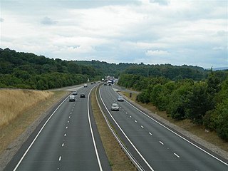
The A483, officially described as the Swansea to Manchester Trunk Road, although now ending in Chester, is a major road in the United Kingdom. It runs from Swansea in Wales to Chester in England via Llandovery, Llandrindod Wells, Oswestry and Wrexham, a distance of around 153 miles (246 km).

The Ellesmere Canal was a waterway in England and Wales that was planned to carry boat traffic between the rivers Mersey and Severn. The proposal would create a link between the Port of Liverpool and the mineral industries in north east Wales and the manufacturing centres in the West Midlands. However, the canal was never completed as intended because of its rising costs and failure to generate the expected commercial traffic.

The Llangollen Canal is a navigable canal crossing the border between England and Wales. The waterway links Llangollen in Denbighshire, north Wales, with Hurleston in south Cheshire, via the town of Ellesmere, Shropshire. The name, which was coined in the 1980s, is a modern designation for parts of the historic Ellesmere Canal and the Llangollen navigable feeder, both of which became part of the Shropshire Union Canals in 1846.
The Pontcysyllte Aqueduct is a navigable aqueduct that carries the Llangollen Canal across the River Dee in the Vale of Llangollen in northeast Wales.

The Shropshire Union Canal, nicknamed the "Shroppie", is a navigable canal in England. The Llangollen and Montgomery canals are the modern names of branches of the Shropshire Union (SU) system and lie partially in Wales.
The Chester Canal was an English canal linking the south Cheshire town of Nantwich with the River Dee at Chester. It was intended to link Chester to Middlewich, with a branch to Nantwich, but the Trent and Mersey Canal were unco-operative about a junction at Middlewich, and so the route to Nantwich was opened in 1779. There were also difficulties negotiating with the River Dee Company, and with no possibility of through traffic, the canal was uneconomic. Part of it was closed in 1787, when Beeston staircase locks collapsed, and there was no money to fund repairs. When the Ellesmere Canal was proposed in 1790, the company saw it as a ray of hope, and somehow managed to keep the struggling canal open. The Ellesmere Canal provided a link to the River Mersey at Ellesmere Port from 1797, and the fortunes of the Chester Canal began to improve.

The Montgomery Canal, known colloquially as "The Monty", is a partially restored canal in eastern Powys and northwest Shropshire. The canal runs 33 miles (53 km) from the Llangollen Canal at Frankton Junction to Newtown via Llanymynech and Welshpool and crosses the England–Wales border.

Llanymynech is a village straddling the border between Montgomeryshire/Powys, Wales, and Shropshire, England, about 9 miles (14 km) north of the Welsh town of Welshpool. The name is Welsh for "Church of the Monks". The village is on the banks of the River Vyrnwy, and the Montgomery Canal passes through it.

The National Waterways Museum (NWM) is in Ellesmere Port, Cheshire, England, at the northern end of the Shropshire Union Canal where it meets the Manchester Ship Canal. The museum's collections and archives focus on the Britain's navigable inland waterways, including its rivers and canals, and include canal boats, traditional clothing, painted canal decorative ware and tools. It is one of several museums and attractions operated by the Canal & River Trust, the successor to The Waterways Trust.
The Shrewsbury Canal was a canal in Shropshire, England. Authorised in 1793, the main line from Trench to Shrewsbury was fully open by 1797, but it remained isolated from the rest of the canal network until 1835, when the Birmingham and Liverpool Junction Canal built the Newport Branch from Norbury Junction to a new junction with the Shrewsbury Canal at Wappenshall. After ownership passed to a series of railway companies, the canal was officially abandoned in 1944; many sections have disappeared, though some bridges and other structures can still be found. There is an active campaign to preserve the remnants of the canal and to restore the Norbury to Shrewsbury line to navigation.
The Shropshire Union Railways and Canal Company was a Company in England, formed in 1846, which managed several canals and railways. It intended to convert a number of canals to railways, but was leased by the London and North Western Railway (LNWR) from 1847, and although they built one railway in their own right, the LNWR were keen that they did not build any more. They continued to act as a semi-autonomous body, managing the canals under their control, and were critical of the LNWR for not using the powers which the Shropshire Union Company had obtained to achieve domination of the markets in Shropshire and Cheshire by building more railways.

Pant is a village in Shropshire, England. It lies near the border with Wales. Pant means 'hollow' in Welsh: it is located directly below the disused mines at Llanymynech Rocks Nature Reserve. The population at the 2011 census is listed under the Civil Parish of Llanymynech and Pant. The built-up area of Pant and Llanymynech is roughly 2,000.

The Shropshire Canal was a tub boat canal built to supply coal, ore and limestone to the industrial region of east Shropshire, England, that adjoined the River Severn at Coalbrookdale. It ran from a junction with the Donnington Wood Canal ascending the 316 yard long Wrockwardine Wood inclined plane to its summit level, it made a junction with the older Ketley Canal and at Southall Bank the Coalbrookdale (Horsehay) branch went to Brierly Hill above Coalbrookdale; the main line descended via the 600 yard long Windmill Incline and the 350 yard long Hay Inclined Plane to Coalport on the River Severn. The short section of the Shropshire Canal from the base of the Hay Inclined Plane to its junction with the River Severn is sometimes referred to as the Coalport Canal.

Frankton Junction is the name of the canal junction where the Montgomery Canal terminates and meets the Llangollen Canal at Lower Frankton, Shropshire, England.

Hurleston Junction is the name of the canal junction where the Llangollen Canal terminates and meets the Shropshire Union Canal main line at Hurleston, Cheshire, England.
Montgomery Waterway Restoration Trust is a British registered charity, number 510448, which exists to promote the restoration of the Montgomery Canal.

Llanymynech railway station was an important junction station on the Cambrian Railways mainline from Welshpool, Powys to Oswestry, Shropshire, serving the village of Llanymynech which is partly situated in Shropshire, England and partly in Powys, Wales.

Llanymynech Heritage Area is an historic former lime kiln, quarry and industrial site near the village of Llanymynech, Shropshire in the Welsh Marches. The site is adjacent to the A483 road and close to the Montgomery Canal. It is about 6 miles (10 km) south of Oswestry on the English side of the border, and about 9 miles (14 km) north of the Powys town of Welshpool.