
Continental Europe or mainland Europe is the contiguous mainland of Europe, excluding its surrounding islands. It can also be referred to ambiguously as the European continent, – which can conversely mean the whole of Europe – and, by some, simply as the Continent. When Eurasia is regarded as a single continent, Europe is treated both as a continent and subcontinent.
Nigeria’s transport network has expanded in recent years to accommodate a growing population. The transport and storage sector was valued at N2.6trn ($6.9bn) in current basic prices in 2020, down from N3trn ($8bn) in 2019, according to the National Bureau of Statistics (NBS). This was reflected in a lower contribution to GDP, at 1.8% in the fourth quarter of 2020, down from 2.1% during the same period the previous year but higher than the 0.8% recorded in the third quarter of 2020. One of the most significant challenges facing the sector is meeting the needs of both large coastal cities and rural inland communities in order to fully unlock the country’s economic potential. This is especially the case with mining and agriculture, both of which are expected to benefit from two large-scale projects: the Lekki Port in Lagos and the Kano-Maradi rail line in the north of the country.

Zanzibar is an insular semi-autonomous region which united with Tanganyika in 1964 to form the United Republic of Tanzania. It is an archipelago in the Indian Ocean, 25–50 km (16–31 mi) off the coast of the African mainland, and consists of many small islands and two large ones: Unguja and Pemba Island. The capital is Zanzibar City, located on the island of Unguja. Its historic centre, Stone Town, is a World Heritage Site.
Ilha de Itamaracá is a tropical island and municipality in Pernambuco, Brazil on the Atlantic Ocean. Itamaracá means "stone shaker" in Tupi, from the words itá ("stone") and mbara'ká ("shaker"). It is separated from the mainland by the Canal de Santa Cruz, a salt water channel both mouths of which are on the Atlantic Ocean, and is connected to the mainland by a long road bridge.
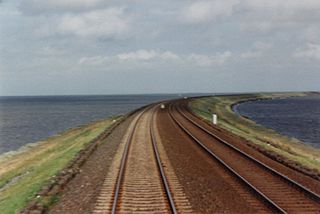
A causeway is a track, road or railway on the upper point of an embankment across "a low, or wet place, or piece of water". It can be constructed of earth, masonry, wood, or concrete. One of the earliest known wooden causeways is the Sweet Track in the Somerset Levels, England, which dates from the Neolithic age. Timber causeways may also be described as both boardwalks and bridges.

Aquidneck Island, officially known as Rhode Island, is an island in Narragansett Bay in the state of Rhode Island. The total land area is 37.8 sq mi (98 km2), which makes it the largest island in the bay. The 2020 United States Census reported its population as 60,109. The state of Rhode Island is named after the island; the United States Board on Geographic Names recognizes Rhode Island as the name for the island, although it is widely referred to as Aquidneck Island in the state and by the island's residents.

São Vicente is a coastal municipality in southern São Paulo, Brazil. It is part of the Metropolitan Region of Baixada Santista. The population is 329,911 in an area of 148,151 square kilometres.

Salsette Island is an island in Konkan division of the state of Maharashtra, along India's west coast. Administratively known as Greater Mumbai, the Mumbai Suburban district, Mira Bhayander and a portion of Thane district lie within it, making it very populous and one of the most densely populated islands in the world. It has a population of more than 20 million inhabitants living on an area of about 619 square kilometres (239 sq mi).

Lagos Island is the principal and central Local Government Area (LGA) in Lagos, Nigeria. It was the capital of Lagos State until 1957. It is part of the Lagos Division. As of the preliminary 2006 Nigerian census, the LGA had a population of 209,437 in an area of 8.7 km2. The LGA only covers the western half of Lagos Island; the eastern half is simply referred to as Lagos Island East LCDA.

The Hercílio Luz Bridge, located in Florianópolis, the capital city of Santa Catarina State in southern Brazil, is the first bridge constructed to link the Island of Santa Catarina to the mainland.
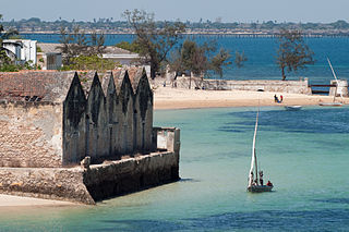
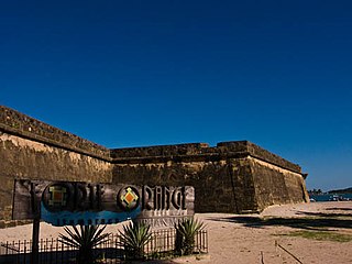
The Island of Mozambique lies off northern Mozambique, between the Mozambique Channel and Mossuril Bay, and is part of Nampula Province. Prior to 1898, it was the capital of colonial Portuguese East Africa. With its rich history and sandy beaches, the Island of Mozambique is a UNESCO World Heritage Site and one of Mozambique's fastest-growing tourist destinations. It has a permanent population of approximately 14,000 people and is served by nearby Lumbo Airport on the Nampula mainland. The name of the country, Mozambique, is derived from the name of this island.

Qeshm is an arrow-shaped Iranian island in the Strait of Hormuz, separated from the mainland by the Clarence Strait/Khuran in the Persian Gulf. and the largest in the Persian Gulf.

The Outer Banks are a 200 mi (320 km) string of barrier islands and spits off the coast of North Carolina and southeastern Virginia, on the east coast of the United States. They line most of the North Carolina coastline, separating Currituck Sound, Albemarle Sound, and Pamlico Sound from the Atlantic Ocean. A major tourist destination, the Outer Banks are known for their wide expanse of open beachfront and the Cape Hatteras National Seashore. The seashore and surrounding ecosystem are important biodiversity zones, including beach grasses and shrubland that help maintain the form of the land.

Vypin is one of the group of islands that form part of the city of Kochi (Cochin), in the Indian state of Kerala. Vypin forms a barrier island which lies between the Arabian Sea in the west and the Cochin backwaters formed by the various distributaries of Periyar river, in the east. The northernmost end of the island lies on the estuary of the Periyar river in Muziris (Kodungallur), and the southernmost end in the mouth of the Cochin Backwaters in Kalamukku near Fort Vypin.

Santa Catarina Island is an island in the Brazilian state of Santa Catarina, located off the southern coast. It is home to the state capital, Florianópolis.

Eko Bridge is one of three bridges connecting Lagos Island to the mainland, the others are the Third Mainland and Carter bridges. The bridge was built in 1975 and is the shortest of the three bridges linking Lagos Island to mainlaind.
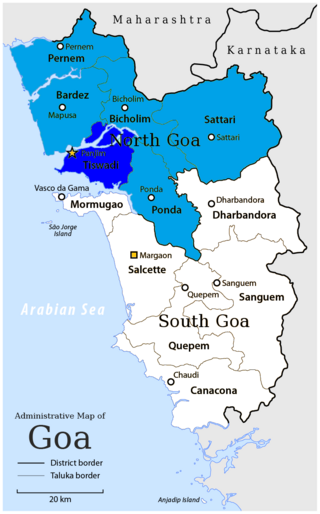
Tiswadi, formerly known as Ilhas, is a taluka in the district of North Goa, situated in the Indian coastal state of Goa. It is an estuarine island situated on the confluence of the Mandovi and Zuari rivers. It was one of the first territories to be annexed by the Portuguese in the 16th century. Both the state capital Panaji, and the erstwhile capital Old Goa lie within the sub-district. It is the biggest and the most populated of the six major islands between the Mandovi and Zuari rivers.

Madre de Deus is a municipality in the state of Bahia in the North-East region of Brazil. The municipality is located on a small archipelago in the Bay of All Saints; it both the smallest municipality by land mass in Bahia and the Northeastern region of Brazil. Madre de Deus is spread across two islands, the Ilha de Madre de Deus and the much smaller Ilha de Maria Guarda. It sits in close proximity to two others islands, the Ilha do Bom Jesus dos Passos and Ilha dos Frades, both part of the city of Salvador. The Ilha de Madre de Deus is further subdivided into the neighborhoods of Centro, Suape, Cação, Marezinha, Mirim, Alto do Paraíso, Apicum, Nova Madre de Deus e Quitéria, Alto da Matriz, Alto do Santo Antônio, Alto da Boa Vista, Cururupeba, Malvinas, and Nova Brasília.

Mozambique Island Bridge is a bridge in Mozambique that connects the Island of Mozambique, the former capital of colonial Portuguese East Africa to the mainland over the Indian Ocean.

Alameda Island is an island located in the San Francisco Bay in California. It is south and west of, and adjacent to, Oakland, and across the bay eastward from San Francisco. Located on the island is most of the city of Alameda, a city in Alameda County. A very small western tip of the island's territory is technically part of San Francisco, however, this is uninhabited and is not separately managed.
