Moose Creek (Bearpaw River tributary)

Last updated
Moose Creek
Location
Country United States
State Alaska
Physical characteristics
Mouth Bearpaw River
  location
Diamond, Alaska, United States
  coordinates
63°53′18″N150°54′14″W / 63.8883333°N 150.9038889°W / 63.8883333; -150.9038889 Coordinates: 63°53′18″N150°54′14″W / 63.8883333°N 150.9038889°W / 63.8883333; -150.9038889 [1]
  elevation
548 ft (167 m)
Basin features
Tributaries 
  left Lake Creek

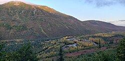
Moose Creek heads in Denali National Park and Preserve and is a tributary of the Bearpaw River in central Alaska. Wonder Lake drains into Moose Creek. Variant names include Hutenaal'eey No' and Hutenaal'eeyh No' Hutl'ot. [1]

Related Research Articles

Moose Jaw City in Saskatchewan, Canada

Moose Jaw is the fourth largest city in Saskatchewan, Canada. Lying on the Moose Jaw River in the south-central part of the province, it is situated on the Trans-Canada Highway, 77 km (48 mi) west of Regina. Residents of Moose Jaw are known as Moose Javians. The city is surrounded by the Rural Municipality of Moose Jaw No. 161.

Moosehead Lake

Moosehead Lake is the largest lake in the U.S. state of Maine and the largest mountain lake in the eastern United States. Situated in the Longfellow Mountains in the Maine Highlands Region, the lake is the source of the Kennebec River. Towns that border the lake include Greenville to the south and Rockwood to the northwest. There are over 80 islands in the lake, the largest being Sugar Island with the almost as large Deer Island to the west.

Bears Paw Mountains

The Bears Paw Mountains are an insular-montane island range in North-Central Montana, USA, located approximately 10 miles south of Havre, Montana. Baldy Mountain, which rises 6,916 feet (2,108 m) above sea level, is the highest peak in the range. The Bears Paw Mountains extend in a 45-mile arc between the Missouri River and Rocky Boy Indian Reservation south of Havre.

High Sierra Trail Long-distance hiking trail in the United States

The High Sierra Trail (HST) is a hiking trail in Sequoia National Park, California. The trail crosses the Sierra Nevada from west to east. According to the Yosemite Decimal System, the HST is a Class 1/Class 2 trail, which means simple scrambling, with the possibility of occasional use of the hands for balance.

Black Moshannon Creek

Black Moshannon Creek is a 22.9-mile-long (36.9 km) tributary of Moshannon Creek in Centre County, Pennsylvania in the United States.

Moshannon Creek

Moshannon Creek is a 57.4-mile-long (92.4 km) tributary of the West Branch Susquehanna River in Centre County, Pennsylvania in the United States. Throughout its length, it serves as the boundary between Centre and Clearfield counties.

Moose Creek can refer to:

Kantishna River

The Kantishna River is a 108-mile (174 km) tributary of the Tanana River in the U.S. state of Alaska. Formed by the confluence of the McKinley River with Birch Creek in Denali National Park and Preserve, it drains part of the north slope of the Alaska Range including the Denali massif. The direction of flow is generally north-northeast. The Toklat River is a major tributary.

Pembina River (Alberta) River in Alberta, Canada

The Pembina River is a tributary of the Athabasca River in central Alberta, Canada.

Beaver River (Canada)

Beaver River is a large river in east-central Alberta and central Saskatchewan, Canada. It flows east through Alberta and Saskatchewan and then turns sharply north to flow into Lac Île-à-la-Crosse on the Churchill River which flows into Hudson Bay.

Bearpaw Formation

The Bearpaw Formation, also called the Bearpaw Shale, is a geologic formation of Late Cretaceous (Campanian) age. It outcrops in the U.S. state of Montana, as well as the Canadian provinces of Alberta and Saskatchewan, and was named for the Bear Paw Mountains in Montana. It includes a wide range of marine fossils, as well as the remains of a few dinosaurs. It is known for its fossil ammonites, some of which are mined in Alberta to produce the organic gemstone ammolite.

Santanoni Peak Mountain in New York state, US

Santanoni Peak is a mountain located in Essex County, New York. The mountain is part of the Santanoni Mountains of the Adirondacks. The mountain's name is believed to be an Abenaki derivative of "Saint Anthony"; the first French fur traders and missionaries having named the area for Saint Anthony of Padua. Santanoni Peak is flanked to the north by Panther Peak, and to the southwest by Little Santanoni Mountain.

Kantishna, Alaska Unincorporated community in Alaska, United States

Kantishna is an unincorporated community in Denali Borough, Alaska, United States, within Denali National Park and Preserve. Founded as a gold mining camp in 1905, it endured longer than similar communities in the area, having been constructed nearest to the source of the gold. It lies in the Kantishna Hills at the junction of Eureka Creek and Moose Creek, 3 mi (5 km) northwest of Wonder Lake, and near the mouth of the Kantishna River. Although the community was once also called "Eureka", the Board on Geographic Names officially ruled in favor of "Kantishna" in 1944, the name given to the post office that was built at the site in 1905. Its elevation is 1,696 feet (517 m).

The Moose River is a river in Mount Robson Provincial Park of British Columbia. It is the first "river" tributary of the Fraser, entering the Fraser just above the inlet to Moose Lake, which is along the course of the Fraser and not the Moose.

Diamond or Diamond City is located at the junction of Moose Creek and Bearpaw River, 18 miles (29 km) east of Chilchukabena Lake in Denali Borough, Alaska. Diamond was established c. 1905 as a mining camp at the head of small-boat navigation on the Bearpaw River. It had a post office in 1906 and then again from 1929 until 1951. Diamond is now abandoned.

References

  1. 1 2 "Bearpaw river". Geographic Names Information System . United States Geological Survey . Retrieved 2017-11-27.