Moran Dam

Last updated
Moran Dam
Canada relief map 2.svg
Red pog.svg
Location of the proposed dam in Canada
CountryCanada
LocationNear Lillooet, British Columbia
Coordinates 50°55′26″N121°52′11″W / 50.92389°N 121.86972°W / 50.92389; -121.86972
StatusProposed
Construction began1955
Opening dateNever
Construction cost US$ 4.15 billion [n 1] (projected)
Dam and spillways
Type of dam Concrete thick arch
Impounds Fraser River
Height261 m (856 ft) [2]
Length950 m (3,120 ft) [n 2]
Reservoir
Total capacity35.4 km3 (28,700,000 acre⋅ft) [4]
Catchment area 146,500 km2 (56,600 sq mi) [n 3]
Maximum length260 km (160 mi) [1]
Normal elevation460 m (1,510 ft) [n 4]
Hydraulic head 220 m (720 ft) [6]
Installed capacity 14,000 MW [2]
Capacity factor 23.97% [n 5]
Annual generation 30 billion KWh [n 6]

Moran Dam, also called High Moran Dam or Moran Canyon Dam, was a 1950s proposal to dam the Fraser River in the Canadian province of British Columbia (BC). The structure was planned in the wake of devastating floods in a time of rapidly growing power demand, and if built, would have powered the largest hydroelectric facility in North America. After a protracted environmental battle, Moran Dam was defeated in 1972, mainly over concerns of its adverse impact on salmon populations in the Fraser River basin. The shelving of the project also influenced cancellation of other hydro developments along the river, and today the Fraser remains one of the most productive salmon fisheries on the continent.

Contents

Proposal

As early as 1934, the Moran Canyon site was identified as an excellent location for a large hydroelectric dam. [10] During the dam-building era of the mid-20th century, [11] up to five major hydropower projects were proposed on the main stem of the Fraser River. The largest of these, a dam near the railway point of Moran, some 20 kilometres (12 mi) upstream of Lillooet, was put forth by the Moran Development Corporation (MDC). [12] This American firm put forth US$500 million in 1952 to finance the construction of the dam, which would have been the tallest in the world. [1] The Fraser River was favoured over other large rivers in BC, such as the Columbia or Peace, because of its relative proximity to urban centres like Vancouver. [13]

The dam would have been 261 metres (856 ft) high, generating as much power on average as Grand Coulee Dam and two Hoover Dams combined. Much of this energy would have been sold to the northwestern United States. [2] It would form a gigantic reservoir 260 kilometres (160 mi) long, containing some 35.4 cubic kilometres (28,700,000 acre⋅ft) of water at maximum pool, [4] reaching almost to the city of Quesnel. [1] A significant portion of this capacity would be reserved for flood control as the dam had been proposed in the wake of major floods that occurred just three years before then, in 1948. [14] The BC government gave MDC clearance to begin preliminary work at the site in 1955. However, MDC lacked the funds to build such a gigantic dam and to acquire all the lands that would be flooded under the reservoir, and a rival company, BC Electric (today part of BC Hydro), acquired similar rights to the site that same year. [15]

Controversy and defeat

…the economic cost of destroyed salmon runs would make the power produced by Moran Dam too expensive.

from Salmon Without Rivers: A History of the Pacific Salmon Crisis [16]

Moran Dam's tremendous height would make artificial fish passage nearly impossible, and would thus cut off a large portion of the Fraser's prodigious runs of Pacific salmon and steelhead trout. [6] During the later 1950s and 1960s, determined opposition from environmentalists including Roderick Haig-Brown, [17] fishermen and others stalled the project, citing that the dam would block access to over 70% of anadromous fish spawning habitat in the Fraser basin. In addition, it would cause losses of up to 50% of catches along the main stem Fraser and its delta below the dam because of sediment blockage, water temperature changes, and flow fluctuations. [18] The defeat of the dam project, which had one of the largest power potentials of any in North America, uniquely occurred during the height of the continent's dam-building era, before determined environmentalist opposition towards dams such as at New Melones, twenty years later. [11] [n 7]

In 1970, BC Hydro released a report that predicted annual provincial rises in power consumption of over 10 percent. As a result, the proposed dam project was briefly revived, to the point at which test bores were made at the site in May of that year. [18] [19] After continuing concern over what the dam would do to the Fraser's salmon runs, the Moran Dam was defeated again in 1972. [20] The downfall of the Moran project led to decreased call for power generation on the Fraser River, as Moran would have been the key facility for that matter. [2] If Moran Dam had been built, the vast construction could open much of the Fraser River for development, to the point where it might have even ended up like the dam-straitjacketed Columbia River. [2] Today, despite its alluring hydroelectric potential, the Fraser River remains one of the longest undammed rivers in North America and one of the continent's most productive salmon fisheries. [2] [21]

See also

Notes

  1. Adjusted for inflation from a figure of $500 million [1] in 1952 dollars.
  2. Measured along the 460 m contour on Canadian topo maps of the Fraser River canyon at the site assuming a straight-axis construction. [3]
  3. Catchment area is estimated from the Water Survey of Canada's "Fraser River at Big Bar Creek" gauge on the Fraser River, the closest one (about 30 km (19 mi) upstream) to the Moran Dam site with a drainage area measurement. [5]
  4. The elevation of the river at the dam site is 240 m (790 ft). [3] The maximum depth of the reservoir would be 220 m (720 ft). [6]
  5. Calculated from the average annual production of 30 billion KWh.
  6. Amount [7] estimated by adding the net annual generation of Grand Coulee Dam (21 billion KWh [8] ) with twice the annual generation of Hoover Dam (8.4 billion KWh [9] ).
  7. During the 1950s, there was also a fight over the proposed Echo Park Dam in Utah in the United States, perhaps one of the most famous dam controversies of all time. However, the conflict was mainly because said dam would have been inside the Dinosaur National Monument. The Moran Dam site was not federally protected, nor was wilderness.

Works cited

Related Research Articles

<span class="mw-page-title-main">Grand Coulee Dam</span> Dam in Grant and Okanogan counties, near Coulee Dam and Grand Coulee, Washington, US

<span class="mw-page-title-main">Stikine River</span> River in British Columbia and Alaska

The Stikine River is a major river in northern British Columbia (BC), Canada and southeastern Alaska in the United States. It drains a large, remote upland area known as the Stikine Country east of the Coast Mountains. Flowing west and south for 610 kilometres (379 mi), it empties into various straits of the Inside Passage near Wrangell, Alaska. About 90 percent of the river's length and 95 percent of its drainage basin are in Canada. Considered one of the last truly wild large rivers in BC, the Stikine flows through a variety of landscapes including boreal forest, steep canyons and wide glacial valleys.

<span class="mw-page-title-main">Columbia Basin Project</span> American irrigation project

The Columbia Basin Project in Central Washington, United States, is the irrigation network that the Grand Coulee Dam makes possible. It is the largest water reclamation project in the United States, supplying irrigation water to over 670,000 acres (2,700 km2) of the 1,100,000 acres (4,500 km2) large project area, all of which was originally intended to be supplied and is still classified irrigable and open for the possible enlargement of the system. Water pumped from the Columbia River is carried over 331 miles (533 km) of main canals, stored in a number of reservoirs, then fed into 1,339 miles (2,155 km) of lateral irrigation canals, and out into 3,500 miles (5,600 km) of drains and wasteways. The Grand Coulee Dam, powerplant, and various other parts of the CBP are operated by the Bureau of Reclamation. There are three irrigation districts in the project area, which operate additional local facilities.

<span class="mw-page-title-main">Coquitlam River</span> River in British Columbia, Canada

The Coquitlam River is a tributary of the Fraser River in the Canadian province of British Columbia. The river's name comes from the word Kʷikʷəƛ̓əm which translates to "Red fish up the river". The name is a reference to a sockeye salmon species that once occupied the river's waters.

<span class="mw-page-title-main">Hells Gate (British Columbia)</span> Geographic landmark in British Columbia, Canada

Hells Gate is an abrupt narrowing of British Columbia's Fraser River, located immediately downstream of Boston Bar in the southern Fraser Canyon. The towering rock walls of the Fraser River plunge toward each other forcing the waters through a passage only 35 metres (115 ft) wide. It is also the name of the rural locality at the same location.

The Columbia River Treaty is a 1961 agreement between Canada and the United States on the development and operation of dams in the upper Columbia River basin for power and flood control benefits in both countries. Four dams were constructed under this treaty: three in the Canadian province of British Columbia and one in the U.S. state of Montana.

<span class="mw-page-title-main">Bridge River</span> River in British Columbia, Canada

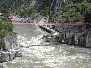
The Bridge River is an approximately 120 kilometres (75 mi) long river in southern British Columbia. It flows south-east from the Coast Mountains. Until 1961, it was a major tributary of the Fraser River, entering that stream about six miles upstream from the town of Lillooet; its flow, however, was near-completely diverted into Seton Lake with the completion of the Bridge River Power Project, with the water now entering the Fraser just south of Lillooet as a result.

<span class="mw-page-title-main">Stave River</span> River in British Columbia, Canada

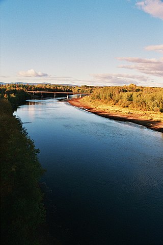
The Stave River is a tributary of the Fraser, joining it at the boundary between the municipalities of Maple Ridge and Mission, about 35 kilometres (22 mi) east of Vancouver, British Columbia, Canada, in the Central Fraser Valley region.

<span class="mw-page-title-main">Nechako River</span> River in British Columbia, Canada

The Nechako River arises on the Nechako Plateau east of the Kitimat Ranges of the Coast Mountains of British Columbia, Canada, and flows north toward Fort Fraser, then east to Prince George where it enters the Fraser River. "Nechako" is an anglicization of netʃa koh, its name in the indigenous Carrier language which means "big river".

<span class="mw-page-title-main">Niut Range</span>

The Niut Range is 3600 km2 in area. It is a subrange of the Pacific Ranges of the Coast Mountains of British Columbia, although in some classifications it is considered part of the Chilcotin Ranges. The Niut is located in the angle of the Homathko River and its main west fork, Mosley Creek. It is isolated, island-like, by those rivers from its neighbour ranges, as both streams have their source on the Chilcotin Plateau in behind the range. Razorback Mountain is its highest peak.

<span class="mw-page-title-main">Bridge River Power Project</span>

The Bridge River Power Project is a hydroelectric power development in the Canadian province of British Columbia, located in the Lillooet Country between Whistler and Lillooet. It harnesses the power of the Bridge River, a tributary of the Fraser, by diverting it through a mountainside to the separate drainage basin of Seton Lake, utilizing a system of three dams, four powerhouses and a canal.

<span class="mw-page-title-main">Kenney Dam</span> Dam in British Columbia, Canada

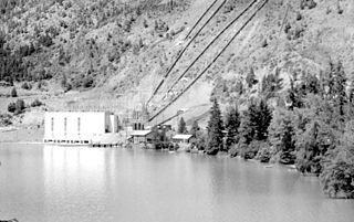
The Kenney Dam is a rock-fill embankment dam on the Nechako River in northwestern British Columbia, built in the early 1950s. The impoundment of water behind the dam forms the Nechako Reservoir, which is also commonly known as the Ootsa Lake Reservoir. The dam was constructed to power an aluminum smelter in Kitimat, British Columbia by Alcan, although in the late 1980s the company increased their economic activity by selling excess electricity across North America. The development of the dam caused various environmental problems along with the displacement of the Cheslatta T'En First Nation, whose traditional land was flooded.

The Nechako Reservoir, sometimes called the Ootsa Lake Reservoir, is a hydroelectric reservoir in British Columbia, Canada that was formed by the Kenney Dam making a diversion of the Nechako River through a 16-km intake tunnel in the Kitimat Ranges of the Coast Mountains to the 890 MW Kemano Generating Station at sea level at Kemano to service the then-new Alcan aluminum smelter at Kitimat. When it was constructed on the Nechako River in 1952, it resulted in the relocation of over 75 families. It was one of the biggest reservoirs built in Canada until the completion of the Columbia Treaty Dams and the W.A.C. Bennett Dam that created Lake Williston. The water level may swing 10 feet between 2790 and 2800 feet.

According to the International Hydropower Association, Canada is the fourth largest producer of hydroelectricity in the world in 2021 after the United States, Brazil, and China. In 2019, Canada produced 632.2 TWh of electricity with 60% of energy coming from Hydroelectric and Tidal Energy Sources).

<span class="mw-page-title-main">Iskut River</span> River in British Columbia, Canada

The Iskut River, located in the northwest part of the province of British Columbia is the largest tributary of the Stikine River, entering it about 11 km (6.8 mi) above its entry into Alaska.

The Bridge River Rapids, also known as the Six Mile Rapids, the Lower Fountain, the Bridge River Fishing Grounds, and in the St'at'imcets language as Sat' or Setl, is a set of rapids on the Fraser River, located in the central Fraser Canyon at the mouth of the Bridge River six miles north of the confluence of Cayoosh Creek with the Fraser and on the northern outskirts of the District of Lillooet, British Columbia, Canada.

The Cheslatta Carrier Nation or Cheslatta T'En, of the Dakelh or Carrier people (Ta-cullies, meaning "people who go upon water" is a First Nation of the Nechako River at the headwaters of the Fraser River.

The Stung Treng Dam is a proposed hydroelectric dam on the Mekong River in Stung Treng Province, Cambodia. It would be located on the mainstream of the Lower Mekong River. The project is controversial for several reasons, including its possible impact on the fisheries, as well as other ecological and environmental factors.

<span class="mw-page-title-main">Pacific Salmon Commission</span>

The Pacific Salmon Commission is a regulatory body run jointly by the Canadian and United States governments. Its mandate is to protect stocks of the five species of Pacific salmon. Its precursor was the International Pacific Salmon Fisheries Commission, which operated from 1937 to 1985. The PSC enforces the Pacific Salmon Treaty, ratified by Canada and the U.S. in 1985.

<span class="mw-page-title-main">Ruskin Dam and Powerhouse</span> Dam in Ruskin, British Columbia

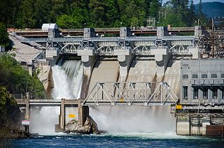
Ruskin Dam is a concrete gravity dam on the Stave River in Ruskin, British Columbia, Canada. The dam was completed in 1930 for the primary purpose of hydroelectric power generation. The dam created Hayward Lake, which supplies water to a 105 MW powerhouse and flooded the Stave's former lower canyon, which ended in a small waterfall approximately where the dam is today.

References

  1. 1 2 3 4 Nanton, Isabel (1999-10-09). "World's Biggest Dam Once Proposed for BC: The plan put forward by U.S. financiers in 1952 called for a 270-metre-high dam at Moran Canyon on the Fraser River". Vancouver Sun. Archived from the original on 2008-07-25. Retrieved 2011-06-25.
  2. 1 2 3 4 5 6 Ferguson, John W.; Healey, Michael; Dugan, Patrick; Barlow, Chris (2009-09-17). "Potential Effects of Dams on Migratory Fish in the Mekong River: Lessons from Salmon in the Fraser and Columbia Rivers" (PDF). College of Natural Resources. University of Idaho. Archived from the original (PDF) on 2011-09-28. Retrieved 2011-06-25.
  3. 1 2 CTIO Topo Maps for Canada (Map). Cartography by Natural Resources Canada Centre for Topographic Information. ACME Mapper. Retrieved 2011-06-26.
  4. 1 2 Evenden, p. 214
  5. "HYDAT Database Text Search: Fraser River". Water Survey of Canada. Environment Canada. Archived from the original on 2010-12-24. Retrieved 2011-06-26.
  6. 1 2 3 Bengeyfield, W.; et al. (June 2001). "Evaluation of Restoring Historic Passage for Anadromous Fish at BC Hydro Facilities" (PDF). BC Hydro. Archived from the original (PDF) on 2011-06-12. Retrieved 2011-06-25.
  7. "Hydropower in the Fraser and Columbia Rivers: a contrast in approaches to fisheries protection". Fisheries Research and Development in the Mekong Region. Mekong River Commission For Sustainable Development. Retrieved 2011-06-25.
  8. "Grand Coulee Powerplant". Grand Coulee Dam. U.S. Bureau of Reclamation. 2010-12-20. Retrieved 2011-06-25.
  9. Mcintyre, Douglas (2011-03-23). "How to Pay Down the Federal Deficit: Sell America's Icons, Assets and Gold?". DailyFinance. Retrieved 2011-06-25.
  10. Evenden, p. 186
  11. 1 2 Quinn, Frank. "Dams and Diversions". The Canadian Encyclopedia. Retrieved 2011-06-25.
  12. Evenden, p. 183
  13. Evenden, p. 192
  14. McGillivray, p. 160
  15. Evenden, p. 193
  16. Lichatowich and Lichatowich, p. 196
  17. Hume, Mark (2005-04-03). "Roderick Haig-Brown: Before Greenpeace, before Suzuki, he defined conservationist" (PDF). Bell Globemedia. Retrieved 2011-06-25.
  18. 1 2 "The campaign against the Moran Dam created an awareness that helped people to understand the threat to fish posed by Kemano II" (PDF). The Fisherman. Fisheries Center. 1995-06-26. Retrieved 2011-06-25.
  19. Mair, Rafe (2005-07-18). "Questions about Power in BC: Offered here, a handful of dots that may, or may not, connect". The Tyee. Retrieved 2011-06-25.
  20. "History of Conservation: Important events which have led to salmon conservation in British Columbia". BC Heritage Digital Collections. Archived from the original on 2011-10-01. Retrieved 2011-06-25.
  21. Careless, Ric (February 2005). "Lillooet-Lytton Tourism Diversification Project" (PDF). Wilderness Tourism Association. BC Spaces for Nature. Retrieved 2011-06-25.