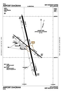
Bert Mooney Airport is a public airport three miles southeast of Butte, in Silver Bow County, Montana, United States. It is owned by the Bert Mooney Airport Authority.
Great Falls International Airport is a public/military airport in city limits three miles southwest of central Great Falls in Cascade County, Montana, United States. The airport has also been called Great Falls Municipal Airport.
Yellowstone Regional Airport is a public-use airport located two nautical miles (3.7 km) southeast of the central business district of Cody, a city in Park County, Wyoming, United States. It is the only commercial airport in Park County Wyoming. It is in northwestern Wyoming, about 53 miles from the east entrance of Yellowstone National Park.

Helena Regional Airport is a public airport two miles northeast of Helena, in Lewis and Clark County, Montana, United States. It is owned by the Helena Regional Airport Authority.
Missoula Montana Airport is located in Missoula, in Missoula County, Montana. It is owned by the Missoula County Airport Authority.
Broadus Airport is a county-owned, public-use airport located three miles (5 km) northwest of the central business district of Broadus, a town in Powder River County, Montana, United States. This new airport was built at a cost of $2 million to replace the old Broadus Airport which is now closed.
Branch County Memorial Airport is a county-owned, public-use airport located three nautical miles (6 km) west of the central business district of Coldwater, a city in Branch County, Michigan, United States. It is included in the Federal Aviation Administration (FAA) National Plan of Integrated Airport Systems for 2017–2021, in which it is categorized as a local general aviation facility.
Bowman Field is a public airport located three miles (5 km) northeast of the central business district of Anaconda, a city in Deer Lodge County, Montana, United States. It is owned by Anaconda City and Deer Lodge County.

Hartselle–Morgan County Regional Airport is a public-use airport located two nautical miles south of the central business district of Hartselle, a city in Morgan County, Alabama, United States. The airport was formerly known as Rountree Field, named in the 1960s for Asa Rountree Sr., a former head of the Alabama Department of Aeronautics.
Liberty County Airport is a county-owned airport a mile west of Chester, in Liberty County, Montana.
Dillon Airport is a county-owned airport five miles northeast of Dillon, in Beaverhead County, Montana.

Dell Flight Strip is a public-use airport located one nautical mile northwest of the central business district of Dell, in Beaverhead County, Montana, United States. It is owned by the Montana Department of Transportation Aeronautics Division and provides general aviation service.
Red Lodge Airport is a public use airport located one nautical mile northwest of the central business district of Red Lodge, a city in Carbon County, Montana, United States. It is owned by the City of Red Lodge and Carbon County. According to the FAA's National Plan of Integrated Airport Systems for 2009–2013, it is categorized as a general aviation airport.
Baker Municipal Airport is a public-use airport located one nautical mile southeast of the central business district of Baker, a city in Fallon County, Montana, United States. The airport is owned by Baker City and Fallon County. It is included in the FAA's National Plan of Integrated Airport Systems for 2011–2015, which categorized it as a general aviation facility.
Big Sandy Airport is a public use airport in Chouteau County, Montana, United States. It is owned by the Town of Big Sandy and located one nautical mile (2 km) south of its central business district. This airport is included in the National Plan of Integrated Airport Systems for 2011–2015, which categorized it as a general aviation facility.
Lincoln Airport is a public use airport located two nautical miles (4 km) east of the central business district of Lincoln, in Lewis and Clark County, Montana, United States. It is owned by the Montana Aeronautics Division. This airport is included in the National Plan of Integrated Airport Systems for 2011–2015, which categorized it as a general aviation facility.
Stanford Airport is a county-owned, public-use airport located one nautical mile (2 km) south of the central business district of Stanford, Judith Basin County, Montana. It is included in the National Plan of Integrated Airport Systems for 2011–2015, which categorized it as a general aviation facility.
Turner Airport is a public use airport in Blaine County, Montana, United States. It is owned by Blaine County and located one nautical mile (2 km) northeast of the central business district of Turner, Montana. This airport is included in the National Plan of Integrated Airport Systems for 2011–2015, which categorized it as a general aviation facility.
Polson Airport is a public use airport in Lake County, Montana, United States. It is located one nautical mile (2 km) west of the central business district of Polson, a city on the southern shore of Flathead Lake. The airport is owned by the City of Polson and Lake County. It is included in the National Plan of Integrated Airport Systems for 2011–2015, which categorized it as a general aviation facility.
Mineral County Airport is a county-owned public-use airport located two nautical miles southeast of the central business district of Superior, a town in Mineral County, Montana, United States. According to the FAA's National Plan of Integrated Airport Systems for 2011–2015, it is categorized as a general aviation facility.
