
Tehachapi Pass is a mountain pass crossing the Tehachapi Mountains in Kern County, California in the United States. Traditionally, the pass marks the northeast end of the Tehachapis and the south end of the Sierra Nevada range.

U.S. Route 199 (US 199) is a U.S. highway in the U.S. states of California and Oregon. The highway was established in 1926 as a spur of U.S. Route 99, which has since been replaced by Interstate 5. US 199 stretches 80 miles (130 km) from U.S. Route 101 near Crescent City, California northeast to Interstate 5 in Grants Pass, Oregon. The highway is the northern portion of the Redwood Highway. In Oregon, US 199 is officially known as Redwood Highway No. 25. The majority of the road in California is the Smith River Scenic Byway, a National Forest Scenic Byway. The first roadway, a plank road, from Crescent City was established in May 1858, and before the US 199 designation was applied to the highway, the roadway was designated Highway 25 and Route 1.
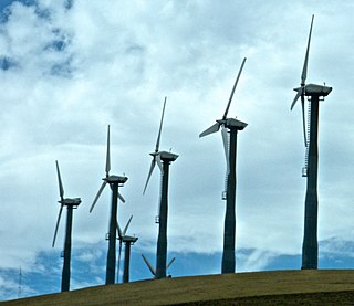
Altamont Pass, formerly Livermore Pass, is a low mountain pass in the Diablo Range of Northern California between Livermore in the Livermore Valley and Tracy in the San Joaquin Valley. The name is actually applied to two distinct but nearby crossings of the range. The lower of the two, at an elevation of 741 ft (226 m), carries two railroad rights-of-way (ROWs) and Altamont Pass Road, part of the old Lincoln Highway and the original alignment of US 50 before it was bypassed c. 1937. The bypass route travels over the higher summit, at 1,009 ft (308 m), and now carries Interstate 580, a major regional highway heavily congested by Central Valley suburbanization.

The Great Divide Basin or Great Divide Closed Basin is an area of land in Wyoming's Red Desert where none of the water falling as rain to the ground drains into any ocean, directly or indirectly. It is therefore considered an endorheic basin, and it adjoins the Continental Divide in southern Wyoming. To the west of the basin is the Green River watershed, draining to the Gulf of California/Pacific Ocean; to the north is the North Platte watershed, draining to the Gulf of Mexico/Atlantic Ocean. The basin is very roughly rectangular in shape; the northwest corner is at Oregon Buttes near South Pass, about 40 miles (64 km) southwest of Lander, and the southeast corner is in the Sierra Madre Range near Bridger Pass, about 20 miles (32 km) southwest of Rawlins.

Sherwin Summit is a mountain pass on U.S. Highway 395.

Sonora Pass is the second-highest highway pass in the Sierra Nevada, lower by 321 ft. than Tioga Pass to the south. State Route 108 traverses the pass.

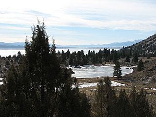
Lake Helen is a glacial lake or a tarn occupying a cirque at around 8,200 feet in Lassen Volcanic National Park. The lake is located to the south of Lassen Peak and west of Bumpass Mountain in the Shasta Cascades region of Northern California. Highway 89 runs along the lake's southern and eastern shore. The lake is named for Helen Tanner Brodt who in 1864 became the first woman to reach the summit of Lassen Peak.

Slumgullion Pass, elevation 11,530 ft (3,510 m), is a mountain pass in Colorado traversed by State Highway 149 east of Lake City. The north side has the steepest grade of any continuously paved road in Colorado (9%), but the pass does not close often in winter because snowplows clear the route regularly during this season. It has a few switchbacks and tight spots, but other than that, most travelers will find it an easy, scenic route.

Summit Lake is a lake in the Lassen Volcanic National Park of Shasta County, California, east of California Route 89 at elevation 6,700 ft (2,000 m). Two campgrounds, named Summit Lake North and Summit Lake South, are located adjacent to the lake.
Emerald Lake is a small lake located nearby Lassen Peak in Lassen Volcanic National Park, in Shasta County, California.
Juniper Lake is a large lake located at the southeast corner of Lassen Volcanic National Park in the U.S. state of California. The lake sits at an elevation of 6,700 ft (2,040 m) above sea level. There is a campground and a ranger station located on the eastern shore of the lake, and a campground and private cabins located on the northern shore. The lake is accessible by an unpaved road from Chester.

Snag Lake is a lake located in the north eastern part of Lassen Volcanic National Park in California.
Horseshoe Lake is a lake located in the eastern part of Lassen Volcanic National Park near Juniper Lake, in Shasta County, California. The lake lies at an elevation of 6,550 ft (1,996 m). Water from Horseshoe Lake drains to Snag Lake via Grassy Creek. The lake is accessible by hiking trail only.

Mendocino Pass is a mountain pass located in the Northern Coast Ranges in California. The pass, in the extreme northwest corner of Glenn County, is at an elevation of about 5,006 feet (1,526 m) and at the gap, two dirt roads intersect. One of them is US Forest Highway 7, a dirt road connecting two disjointed sections of State Route 162. The pass and dirt roads are closed in winter due to heavy snowfall.

Mount Rose Summit is a mountain pass located in the Carson Range near Mount Rose and Slide Mountain northeast of Incline Village. The 8,911 ft (2,716 m)-high pass is traversed by State Route 431, which is the highest point of the highway and the highest mountain pass open year-round in the Sierra Nevada. The saddle itself features a parking lot and a small building which both serve as a highway stop. A closed dirt road leading to the Mount Rose Ski Resort ends near the northern section of the summit.
The Fandango Pass is a gap in the Warner Mountains of Modoc County, California, USA. Located in the Modoc National Forest, its elevation is 6,135 feet (1,870 m) above sea level. It is approximately 5 mi (8.0 km) southwest of Fort Bidwell.

La Veta Pass is the name associated with two nearby mountain passes in the Sangre de Cristo Mountains of south central Colorado in the United States, both lying on the boundary between Costilla and Huerfano counties.
Reas Pass, elevation 6,930 feet (2,110 m), is a mountain pass on the Continental Divide in Fremont County, Idaho, about 8 miles (13 km) southwest of West Yellowstone, Montana. The pass lies essentially on the Idaho-Montana border, but modern maps show that the summit lies entirely in Idaho, because the Divide and the state line do not quite coincide here. The pass is also somewhat unusual in that, despite being the lowest crossing of the Divide in the vicinity, it has evidently never been traversed by a highway of any significance. Starting in 1909, it was used by a branch line of the Union Pacific Railroad running between Ashton, Idaho and West Yellowstone; however, the line eventually became unprofitable and was closed in 1979.

Little Truckee Summit, elevation 6,411 feet (1,954 m), is a mountain pass in Sierra County, California, on the Great Basin Divide between the Middle Fork Feather River to the west and the Little Truckee River to the east. The pass is traversed by State Route 89 northwest of Truckee and southeast of Sierraville.


