
Erosion is the action of surface processes that removes soil, rock, or dissolved material from one location on the Earth's crust and then transports it to another location where it is deposited. Erosion is distinct from weathering which involves no movement. Removal of rock or soil as clastic sediment is referred to as physical or mechanical erosion; this contrasts with chemical erosion, where soil or rock material is removed from an area by dissolution. Eroded sediment or solutes may be transported just a few millimetres, or for thousands of kilometres.

Physical geography is one of the three main branches of geography. Physical geography is the branch of natural science which deals with the processes and patterns in the natural environment such as the atmosphere, hydrosphere, biosphere, and geosphere. This focus is in contrast with the branch of human geography, which focuses on the built environment, and technical geography, which focuses on using, studying, and creating tools to obtain, analyze, interpret, and understand spatial information. The three branches have significant overlap, however.

The Sudetes, also known as the Sudeten Mountains or Sudetic Mountains, is a geomorphological subprovince of the Bohemian Massif province in Central Europe, shared by the Czech Republic, Poland and Germany. They consist mainly of mountain ranges and are the highest part of Bohemian Massif. They stretch from the Saxon capital of Dresden in the northwest across to the region of Lower Silesia in Poland and to the Moravian Gate in the Czech Republic in the east. Geographically the Sudetes are a Mittelgebirge with some characteristics typical of high mountains. Its plateaus and subtle summit relief makes the Sudetes more akin to mountains of Northern Europe than to the Alps.

Paleoclimatology is the scientific study of climates predating the invention of meteorological instruments, when no direct measurement data were available. As instrumental records only span a tiny part of Earth's history, the reconstruction of ancient climate is important to understand natural variation and the evolution of the current climate.

Geomorphology is the scientific study of the origin and evolution of topographic and bathymetric features generated by physical, chemical or biological processes operating at or near Earth's surface. Geomorphologists seek to understand why landscapes look the way they do, to understand landform and terrain history and dynamics and to predict changes through a combination of field observations, physical experiments and numerical modeling. Geomorphologists work within disciplines such as physical geography, geology, geodesy, engineering geology, archaeology, climatology, and geotechnical engineering. This broad base of interests contributes to many research styles and interests within the field.

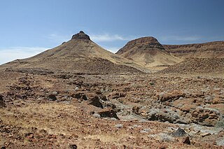
In geomorphology and geology, a peneplain is a low-relief plain formed by protracted erosion. This is the definition in the broadest of terms, albeit with frequency the usage of peneplain is meant to imply the representation of a near-final stage of fluvial erosion during times of extended tectonic stability. Peneplains are sometimes associated with the cycle of erosion theory of William Morris Davis, but Davis and other workers have also used the term in a purely descriptive manner without any theory or particular genesis attached.

Terrain, alternatively relief or topographical relief, is the dimension and shape of a given surface of land. In physical geography, terrain is the lay of the land. This is usually expressed in terms of the elevation, slope, and orientation of terrain features. Terrain affects surface water flow and distribution. Over a large area, it can affect weather and climate patterns. Bathymetry is the study of underwater relief, while hypsometry studies terrain relative to sea level.
Denudation is the geological process in which moving water, ice, wind, and waves erode the Earth's surface, leading to a reduction in elevation and in relief of landforms and landscapes. Although the terms erosion and denudation are used interchangeably, erosion is the transport of soil and rocks from one location to another, and denudation is the sum of processes, including erosion, that result in the lowering of Earth's surface. Endogenous processes such as volcanoes, earthquakes, and tectonic uplift can expose continental crust to the exogenous processes of weathering, erosion, and mass wasting. The effects of denudation have been recorded for millennia but the mechanics behind it have been debated for the past 200 years and have only begun to be understood in the past few decades.
The geographic cycle, or cycle of erosion, is an idealized model that explains the development of relief in landscapes. The model starts with the erosion that follows uplift of land above a base level and ends, if conditions allow, in the formation of a peneplain. Landscapes that show evidence of more than one cycle of erosion are termed "polycyclical". The cycle of erosion and some of its associated concepts have, despite their popularity, been a subject of much criticism.

Morphotectonics, or tectonic geomorphology, is a branch of geomorphology that studies how landforms are formed or affected by tectonic activity. Morphotectonists seek to understand the deep Earth mechanisms behind the creation of tectonic landforms by processes such as crust uplift, subsidence, faulting, or folding.
In geology and geomorphology a pediplain is an extensive plain formed by the coalescence of pediments. The processes through which pediplains forms is known as pediplanation. The concepts of pediplain and pediplanation were first developed by geologist Lester Charles King in his 1942 book South African Scenery. The concept gained notoriety as it was juxtaposed to peneplanation.
A tableland is an area containing elevated landforms characterized by a distinct, flat, nearly level, or gently undulating surface. They often exhibit steep, cliff-like edges, known as escarpments, that separate them from surrounding lowlands. Depending on either their size, other physical characteristics, or geographic location, the landforms comprising a tableland are individually referred to by a number of names including either butte, mesa, plateau, potrero, tepui, or tuya. Table Mountains are also a type of tableland. A homologous landform under the sea is called either a tablemount or guyot.
In geomorphology, cryoplanation or is a term used to both describe and explain the formation of plains, terraces and pediments in periglacial environments. Uncertainty surrounds the term, and the effectiveness of the cryoplanation process is held to be limited meaning it can only produce small terraces. Instead, many of so-called cryoplanation terraces are likely an expression of the underlying lithology and rock structure rather than being unique products of cold-climate processes.
Julius Büdel was a German geomorphologist noted for his work on the influence of climate in shaping landscapes and landforms. In his work Büdel stressed the importance of inherited landforms in present-day landscapes and argued that many landforms are the result of a combination of processes, and not of a single process. Büdel estimated that 95% of mid-latitude landforms are relict. Büdel studied both cold-climate processes in Svalbard and "tropical" weathering processes in India to understand the origin of the relief of Central Europe, which he argued was a palimpsest of landforms formed at different times and under different climates. For Central Europe Büdel concluded that in Late Cretaceous to Early Pliocene times etchplains formed. Then in Late Pliocene to Early Pleistocene times a transition period occurred in landscape forming processes. Finally in the Late Pleistocene periglaciation and deep permafrost made Central Europe a place of "excessive valley cutting". Holocene developments would not have affected much of the landscape other than adding a deep soil cover.

In geology and geomorphology a planation surface is a large-scale land surface that is almost flat with the possible exception of some residual hills. The processes that form planation surfaces are labelled collectively planation and are exogenic. Planation surfaces are planated regardless of bedrock structures. On Earth, they constitute some of the most common landscapes. Geological maps indicate that planation surfaces may comprise 65% of the landscapes on Saturn's largest moon, Titan, which hosts a hydrological cycle of liquid methane. Peneplains and pediplains are types of planation surfaces planated respectively by "peneplanation" and "pediplanation". In addition to these there are planation surfaces proposed to be formed by cryoplanation, marine processes, areal glacial erosion and salt weathering. The term planation surface is often preferred over others because some more specific planation surface types and processes remain controversial. Etchplains are weathered planation surfaces.
A relict, in geology, is a structure or mineral from a parent rock that did not undergo metamorphic change when the surrounding rock did, or a rock that survived a destructive geologic process.
In geography, azonal is an adjective that refers to processes or things that are not restricted to any climate zone. It can be used to describe soils, landforms, geomorphic processes or vegetation. Volcanism and mountain-related processes are examples of azonal processes as they are largely independent of Earth's climate belts. In some climatic environments azonal geomorphologic processes may take distinct characteristics. For example, river activity is common across the globe, but in periglacial environments it causes spring floods from snowmelt, freezing and break-up cycles, and sometimes fluvio-thermal erosion.
An etchplain is a plain where the bedrock has been subject to considerable "etching" or subsurface weathering. Etchplanation is the process forming etchplains. Contrary to what the name might suggest, etchplains are seldom completely flat and usually display some relief, as weathering of the bedrock does not advance uniformly. This means that weathering is unrelated to the flatness which might be derivative of various other processes of planation including peneplanation and pediplanation. Erosion of etchplains can result in the exposure of inselbergs such as bornhardt and tors. Generally the topography exposed at a stripped etchplain, that is an etch surface, after erosion of regolith is one with many irregularities as result of structurally defined areas of rock strength.

Climatic geomorphology is the study of the role of climate in shaping landforms and the earth-surface processes. An approach used in climatic geomorphology is to study relict landforms to infer ancient climates. Being often concerned about past climates climatic geomorphology considered sometimes to be an aspect of historical geology. Since landscape features in one region might have evolved under climates different from those of the present, studying climatically disparate regions might help understand present-day landscapes. For example, Julius Büdel studied both cold-climate processes in Svalbard and weathering processes in tropical India to understand the origin of the relief of Central Europe, which he argued was a palimpsest of landforms formed at different times and under different climates.

The Sub-Mesozoic hilly peneplains or Sub-Mesozoic hilly relief is a landscape in Scandinavia made up of undulating hills and joint valleys and occasional kaolinized bedrock in valley bottoms. The landscape formed in the Mesozoic Era and was eventually drowned by the sea during the Campanian transgression and covered by a thick blanket of Cretaceous sedimentary rocks. Later erosion of the cover rocks partly re-exposed this landscape. During the Quaternary epoch the re-exposed Mesozoic hilly relief escaped major glacier erosion being only surficially scoured in parts.