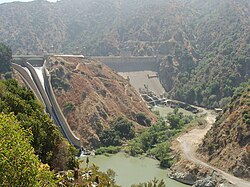
Morris Reservoir Naval Weapons Test Site
The reservoir and its slopes were the Morris Reservoir Naval Weapons Test Site, a naval weapons test facility, from World War II through the 1990s. [2] The reservoir was transferred to the Los Angeles County Department of Public Works in 1995.
The test facility was established by Caltech, which was developing weapons for the Navy at its Naval Ordnance Test Station (NOTS) at China Lake (town), near Ridgecrest, California. It today is now known as the Naval Air Weapons Station China Lake, and is still the primary proving ground for naval weapons systems. Because China Lake is a dry lake in the Mojave Desert, Caltech opened this substation at the Morris Reservoir, near their campus, north of Azusa in the San Gabriel Mountains.
This site was used especially for the development of submarine-based warfare systems, including torpedoes, bombs, and submarine-launched missiles like the Polaris rocket, the first ballistic missile that could be launched from submerged submarines.
Most of the buildings at the site have been removed, and the site is being restored to a "natural" state, and may once again be open to the public.
This page is based on this
Wikipedia article Text is available under the
CC BY-SA 4.0 license; additional terms may apply.
Images, videos and audio are available under their respective licenses.