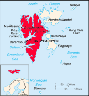
The Svalbard Rocket Range or SvalRak is a launch site for sounding rockets at Ny-Ålesund in Svalbard, Norway. The site has been in use since 1997 and is owned by Andøya Rocket Range, which is owned by the Norwegian Space Centre and the Kongsberg Group. SvalRak's location at the 79th parallel north makes it well-suited for launching rockets to investigate Earth's magnetic field. It is used mostly by American, Japanese and Norwegian researchers. It is the world's northernmost launch site.

Wahlenbergfjorden, sometimes known in English as Waalenburg Bay, is a fjord on the southwest coast of the Arctic island of Nordaustlandet, in Norway's Svalbard archipelago. At 46 kilometres (29 mi) in length, and 15 km (9.3 mi) wide, it is the fifth longest fjord in the archipelago, and the longest on the island. The fjord lies between Gustav V Land and Gustav Adolf Land, at geographical co-ordinates 79°40′N20°00′E. Its mouth faces Spitsbergen across Hinlopen Strait, the strait separating the two islands.
Hinlopen Strait is the strait between Spitsbergen and Nordaustlandet in Svalbard, Norway. It is 150 kilometers (93 mi) long and 10 to 60 kilometers wide. The strait is difficult to pass because of pack ice. It is believed to have been named after Thijmen Jacobsz Hinlopen.
Möllerfjorden is a 9 kilometer long fjord branch of Krossfjorden at the northwestern side of Spitsbergen, Svalbard. The fjord is named after astronomer Didrik Magnus Axel Möller. Möllerfjorden is separated from Lilliehöökfjorden by the peninsula and mountain ridge Kong Haakons Halvøy.
Chauveaubreen is a glacier in Albert I Land at Spitsbergen, Svalbard. The glacier is located between Renaudfjellet and Marstranderfjellet, and debouches into Ayerfjorden, the western branch of Raudfjorden. It is named after French physician Henri Jean Charles Albert Chaveau.
Klinckowströmfjorden is the eastern branch of Raudfjorden at Spitsbergen, Svalbard, on the divide between Albert I Land and Haakon VII Land. It is named after Swedish zoologist Axel Klinckowström. The glacier Raudfjordbreen debouches into the fjord. The peninsula Buchananhalvøya separates Klinckowströmfjorden from the western fjord branch Ayerfjorden. The mountain Ben Nevis is located southeast of the fjord.
Vegafonna is an ice cap in Gustav Adolf Land on Nordaustlandet in the Svalbard archipelago. It is located on the peninsula Scaniahalvøya, between the bay Palanderbukta to the north and Torellneset to the south. The glacier is named after the vessel SS Vega. Further west on the peninsula is the ice cap Glitnefonna.
Kervelbukta is a bay at the eastern side of the glacier Bråsvellbreen in Nordaustlandet, Svalbard. The bay is named after naval officer Johan Henrik van Kervel. Bråsvellbreen, with a twenty nautical miles wide glacier front between Kervelbukta and Vibebukta, exhibited a huge surge in the 1930s.
Torellneset is a headland at the southwestern side of Nordaustlandet, Svalbard. The headland is named after geologist Otto Martin Torell. It is located south of the glacier Vegafonna and is the southwestern point of Gustav Adolf Land. Outside the headland is the island of Perthesøya.
Mosselhalvøya is a peninsula in Ny-Friesland at Spitsbergen, Svalbard. It is located between Mosselbukta and Sorgfjorden. At the northern part of the peninsular is the coastal plain of Verlegenhukflya, with its northernmost point Verlegenhuken.
Valhallfonna is an ice cap in Ny-Friesland at Spitsbergen, Svalbard. It is located west of Hinlopen Strait and northeast of Åsgardfonna. The glacier covers an area of about 1,000 km².
Erik Eriksenstretet is a strait in the Svalbard archipelago, separating Kong Karls Land from Nordaustlandet. It is named after skipper and seal hunter Erik Eriksen, who reportedly discovered Kong Karls Land in 1853, and was the first to enter the islands six years later.
Lernerneset is a headland at the northwestern coast of Abel Island in Kong Karls Land, Svalbard. The headland is named after German Arctic explorer Theodor Lerner. A former variant of the name was Kap Lerner.
Reuschhalvøya is a peninsula in Albert I Land at Spitsbergen, Svalbard. The peninsula is named after geologist Hans Henrik Reusch. It is located south of Smeerenburgfjorden and Bjørnfjorden, and north of Magdalenefjorden. The largest glacier of the peninsula is Scheibreen, while Smeerenburgbreen is located east of the peninsula.
St. Laurentiusbukta is a bay in Albert I Land at Spitsbergen, Svalbard. The bay is located on Reuschhalvøya, east of Scheibukta, at the southern side of Bjørnfjorden. It is named after the saint Laurentius.
Brageneset is a headland at Nordaustlandet, Svalbard. It is located at the mouth of Wahlenbergfjorden. The icecap Vestfonna has the glacier arm Bragebreen which debouches east of Brageneset, and another glacier arm, Gimlebreen debouches into Hinlopen Strait north of Brageneset.
Gyldénøyane is the name of two islands in the mouth of Wahlenbergfjorden at Nordaustlandet, Svalbard. The islands are named after Swedish Arctic explorer Hans Olof Fredrik Gyldén. They are located between the headlands of Selanderneset and Idunneset.
Sparreneset is a headland in Gustav V Land at Nordaustlandet, Svalbard. It is located south of the mouth of Murchisonfjorden, about five nautical miles north of Dolomittøyane and extends about one nautical mile into Hinlopen Strait. The headland is named after Swedish politician Gustaf Adolf Vive Sparre.
Sørgattet is a strait in Albert I Land at Spitsbergen, Svalbard. It runs between Reuschhalvøya and Danes Island, and forms the southern entrance to Smeerenburgfjorden. Moseøya in Sørgattet has a rich birdlife and is protected as a bird sanctuary.
Ole Hansenkammen is a mountain ridge in Haakon VII Land at Spitsbergen, Svalbard. The ridge extends over a length of about 5.5 kilometers, and has peaks of heights 819 and 686 m.a.s.l. It belongs to the mountain group of Generalfjella, along with Tverrkammen and Austflanken. The mountain is named after Norwegian army general Ole Hansen.