The Ring of Fire is a tectonic belt, about 40,000 km (25,000 mi) long and up to about 500 km (310 mi) wide, which circumscribes the Pacific Ocean. It contains between 750 and 915 volcanoes, around two-thirds of the world total, and 90% of the world's earthquakes, including 81% of its largest, take place within the belt.

Mount Bachelor, formerly named Bachelor Butte, is a dormant stratovolcano atop a shield volcano in the Cascade Volcanic Arc and the Cascade Range of central Oregon. Named Mount Bachelor because it stands apart from the nearby Three Sisters, it lies in the eastern segment of the central portion of the High Cascades, the eastern segment of the Cascade Range. The volcano lies at the northern end of the 15-mile (24 km) long Mount Bachelor Volcanic Chain, which underwent four major eruptive episodes during the Pleistocene and the Holocene. The United States Geological Survey considers Mount Bachelor a moderate threat, but Bachelor poses little threat of becoming an active volcano in the near future. It remains unclear whether the volcano is extinct or just inactive.

A shield volcano is a type of volcano named for its low profile, resembling a shield lying on the ground. It is formed by the eruption of highly fluid lava, which travels farther and forms thinner flows than the more viscous lava erupted from a stratovolcano. Repeated eruptions result in the steady accumulation of broad sheets of lava, building up the shield volcano's distinctive form.

The Lassen volcanic area presents a geological record of sedimentation and volcanic activity in and around Lassen Volcanic National Park in Northern California, U.S. The park is located in the southernmost part of the Cascade Mountain Range in the Pacific Northwest region of the United States. Pacific Oceanic tectonic plates have plunged below the North American Plate in this part of North America for hundreds of millions of years. Heat and molten rock from these subducting plates has fed scores of volcanoes in California, Oregon, Washington and British Columbia over at least the past 30 million years, including these in the Lassen volcanic areas.

Lassen Peak, commonly referred to as Mount Lassen, is a lava dome volcano and the southernmost active volcano in the Cascade Range of the Western United States. Located in the Shasta Cascade region of Northern California, it is part of the Cascade Volcanic Arc, which stretches from southwestern British Columbia to northern California. Lassen Peak reaches an elevation of 10,457 ft (3,187 m), standing above the northern Sacramento Valley. It supports many flora and fauna among its diverse habitats, which are subject to frequent snowfall and reach high elevations.

Mount Mazama is a complex volcano in the western U.S. state of Oregon, in a segment of the Cascade Volcanic Arc and Cascade Range. Most of the mountain collapsed following a major eruption approximately 7,700 years ago. The volcano is in Klamath County, in the southern Cascades, 60 miles (97 km) north of the Oregon–California border. Its collapse, due to the eruption of magma emptying the underlying magma chamber, formed a caldera that holds Crater Lake. The mountain is in Crater Lake National Park. Mount Mazama originally had an elevation of 12,000 feet (3,700 m), but following its climactic eruption this was reduced to 8,157 feet (2,486 m). Crater Lake is 1,943 feet (592 m) deep, the deepest freshwater body in the U.S. and the second deepest in North America after Great Slave Lake in Canada.

Mount Tehama is an eroded andesitic stratovolcano in the Cascade Volcanic Arc and the Cascade Range in Northern California. Part of the Lassen volcanic area, its tallest remnant, Brokeoff Mountain, is itself the second highest peak in Lassen Volcanic National Park and connects to the park's highest point, Lassen Peak. Located on the border of Tehama County and Shasta County, Brokeoff's peak is the highest point in the former. The hikers that summit this mountain each year are treated to "exceptional" views of Lassen Peak, the Central Valley of California, and many of the park's other features. On clear days, Mount Shasta can also be seen in the distance.

An active volcano is a volcano that has erupted during the Holocene, is currently erupting, or has the potential to erupt in the future. A volcano that is not currently erupting but could erupt in the future is known as a dormant volcano. Volcanoes that will not erupt again are known as extinct volcanoes.

Heart Peaks, originally known as the Heart Mountains, is a mountain massif in the Northern Interior of British Columbia, Canada. It is 90 km (56 mi) northwest of the small community of Telegraph Creek and just southwest of Callison Ranch. With a maximum elevation of 2,012 m (6,601 ft), it rises above the surrounding landscape on the Nahlin Plateau, which is part of the western Stikine Plateau. Heart Peaks has been an area of prospecting since the 1980s with the discovery of precious metals.

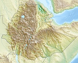
Erta Ale Range is the most important axial volcanic chain of the Afar Depression, Afar Region, Ethiopia. It consists mostly of shield volcanoes.

Mount Tendürek is a shield volcano on the border of Ağrı and Van provinces in eastern Turkey, near the border with Iran. The volcano, which is mostly known for being near the supposed wreck site of Noah's Ark, is very large; its lava flows cover roughly 650 km2 (251 sq mi) across a swath of flat land. The mountain's two main features are the main summit crater Greater Tendürek, and a smaller crater known as Lesser Tendürek which lies to the east of the main crater. The slopes are very gentle and resemble a shield, after which the type is named. Mount Tendürek is known to have erupted viscous lava like that of volcanoes on the island of Hawaii.

Volcanic activity is a major part of the geology of Canada and is characterized by many types of volcanic landform, including lava flows, volcanic plateaus, lava domes, cinder cones, stratovolcanoes, shield volcanoes, submarine volcanoes, calderas, diatremes, and maars, along with less common volcanic forms such as tuyas and subglacial mounds.

The geology of the Pacific Northwest includes the composition, structure, physical properties and the processes that shape the Pacific Northwest region of North America. The region is part of the Ring of Fire: the subduction of the Pacific and Farallon Plates under the North American Plate is responsible for many of the area's scenic features as well as some of its hazards, such as volcanoes, earthquakes, and landslides.
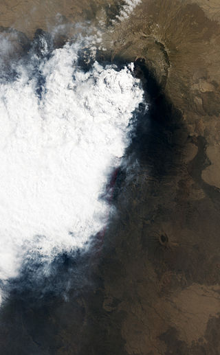
Erta Ale is a continuously active basaltic shield volcano in the Afar Region of northeastern Ethiopia, which is itself part of the wider Afar Triangle. Erta Ale is located in the Danakil Depression, an area below sea level between the last two countries, and is the most active volcano in Ethiopia.
The Mount Edziza volcanic complex is a linear group of volcanoes and associated lava flows in northwestern British Columbia, Canada. Located on the Tahltan Highland, it is 40 kilometres southeast of Telegraph Creek and 85 kilometres southwest of Dease Lake. The complex encompasses a broad, steep-sided lava plateau that extends over 1,000 square kilometres. Its highest summit is 2,786 metres above sea level, making the MEVC the highest of four large complexes in an extensive north–south trending volcanic region. An ice cap obscures the highest summit which is characterized by several outlet glaciers stretching out to lower altitudes.

Dabbahu Volcano is an active volcano located in the remote Afar Region of Ethiopia. This stratovolcano is part of the Afar Triangle, a highly active volcanic region which includes Erta Ale. An eruption on September 26, 2005 created a large fissure in the ground, known as the Dabbahu fissure.

The volcanic history of the Northern Cordilleran Volcanic Province presents a record of volcanic activity in northwestern British Columbia, central Yukon and the U.S. state of easternmost Alaska. The volcanic activity lies in the northern part of the Western Cordillera of the Pacific Northwest region of North America. Extensional cracking of the North American Plate in this part of North America has existed for millions of years. Continuation of this continental rifting has fed scores of volcanoes throughout the Northern Cordilleran Volcanic Province over at least the past 20 million years and occasionally continued into geologically recent times.
The 2011 Nabro eruption was an eruption of the Nabro stratovolcano in the Southern Red Sea Region of Eritrea, which began on 12 June 2011 after a series of earthquakes. The eruption killed seven and possibly a further 31 people and is estimated to be the highest altitude injection of sulfur dioxide (SO2) ever observed by satellite. The Mount Pinatubo eruption 20 years earlier emitted ten times more SO2. The ash cloud from the eruption reached altitudes which disrupted airline traffic in the region. Until the eruption began, the volcano had no records of historical eruptions.