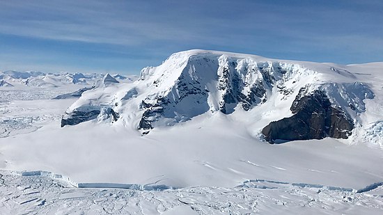
The Sweeney Mountains are a group of mountains of moderate height and about 40 nautical miles extent, located 30 nautical miles north of the Hauberg Mountains in eastern Ellsworth Land, Antarctica.
Northeast Glacier is a steep, heavily crevassed glacier, 13 nautical miles long and 5 nautical miles wide at its mouth, which flows from McLeod Hill westward and then south-westwards into Marguerite Bay between the Debenham Islands and Roman Four Promontory, on the west coast of Graham Land, Antarctica.
Neny Fjord is a bay, 10 nautical miles long in an east–west direction and 5 nautical miles wide, between Red Rock Ridge and Roman Four Promontory on the west coast of Graham Land, Antarctica.

The Eternity Range is a range of mountains 28 nautical miles long, rising to 3,239 metres (10,627 ft), and trending north–south approximately in the middle of the Antarctic Peninsula. The range is divided into three main mountain blocks, the major summits in each from north to south being Mounts Faith, Hope and Charity.

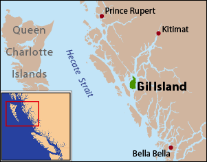
Gil Island is an island on the North Coast of British Columbia, Canada, located on the west side of Whale Channel in the entrance to Douglas Channel, one of the main coastal inlets, on the route of the Inside Passage between Pitt Island and Princess Royal Island. It is 26 km (16 mi) long, with a width ranging from 6 to 13 km, and an area of 231 km2. The only named summit on the mountainous island is Mount Gil, which faces the opening of Douglas Channel.
The Tŝideldel First Nation is the band government of the Tsi Del Del subgroup of the Tsilhqot'in people, located in the Chilcotin District in the western Central Interior region of the Canadian province of British Columbia. It is a member of the Tsilhqot'in National Government.

Arrowsmith Peninsula is a cape about 40 miles (64 km) long on the west coast of Graham Land, west of Forel Glacier, Sharp Glacier and Lallemand Fjord, and northwest of Bourgeois Fjord, with Hanusse Bay lying to the northwest. It was surveyed by the Falkland Islands Dependencies Survey (FIDS) in 1955-58 and named for Edwin Porter Arrowsmith, Governor of the Falkland Islands.
Blaiklock Island is a high and rugged, irregular-shaped island 17 kilometres (9 nmi) long, lying between Bigourdan Fjord and Bourgeois Fjord. It is separated from Pourquoi Pas Island by The Narrows and from the west coast of Graham Land by Jones Channel. The feature was partially surveyed in 1936 by the British Graham Land Expedition under Rymill, at which time it was charted as a promontory. It was determined to be an island in 1949 by Kenneth V. Blaiklock, a Falkland Islands Dependencies Survey (FIDS) surveyor for whom it is named.

Sheldon Glacier is a glacier flowing southeast from Mount Mangin into Ryder Bay, Adelaide Island, Antarctica. Named by the United Kingdom Antarctic Place-Names Committee (UK-APC) in 1977 for Ernest B. Sheldon, British Antarctic Survey (BAS) meteorological observer, Adelaide Station, 1968–69, and Stonington Island, 1969–70; Base Commander, Adelaide Station, 1975–76, and Rothera Station, 1976–77.
Prospect Glacier is a glacier between Kinnear Mountains and Mayer Hills, flowing north into Forster Ice Piedmont on the west coast of Antarctic Peninsula. It was first roughly surveyed in 1936 by the British Graham Land Expedition (BGLE) under Rymill. In 1954 the United Kingdom Antarctic Place-Names Committee (UK-APC) gave the name Prospect Pass to a col between Eureka Glacier and the glacier here described. During resurvey of the area by the Falkland Islands Dependencies Survey (FIDS) in 1958, the col was found to be an indeterminate feature, while this glacier is well marked and requires a name.
Tumble Glacier is a glacier extending along the east side of Alexander Island, Antarctica, 7 nautical miles (13 km) long and 3 nautical miles (6 km) wide, which flows east from the cliffs of Mount Egbert, Mount Ethelwulf and Mount Ethelred of the Douglas Range into the west side of the George VI Ice Shelf that occupies George VI Sound immediately south of Mount King. The glacier was first roughly surveyed in 1936 by the British Graham Land Expedition under Rymill. Resurveyed in 1948 by the Falkland Islands Dependencies Survey, and so named by them because of the extremely broken condition of the lower reaches of the glacier.
Triune Peaks are three prominent, sharply pointed rock peaks, rising 12 nautical miles (22 km) northeast of Mount Balfour and overlooking Wordie Ice Shelf on the west coast of Antarctic Peninsula. First roughly surveyed from the ground by British Graham Land Expedition (BGLE), 1936–37. Photographed from the air by Ronne Antarctic Research Expedition (RARE), December 1947. Resurveyed from the ground by Falkland Islands Dependencies Survey (FIDS), November 1958. The United Kingdom Antarctic Place-Names Committee (UK-APC) name derives from the number of peaks in the group.
Eureka Glacier is a broad, gently sloping glacier, 18 nautical miles (33 km) long and 17 nautical miles (31 km) wide at its mouth, which flows westward from the west side of Palmer Land into George VI Sound. It is bounded on its north side by the nunataks south of Mount Edgell, on its south side by the Traverse Mountains and Terminus Nunatak, and at its head Prospect Glacier provides a route to the Wordie Ice Shelf. It was first surveyed in 1936 by the British Graham Land Expedition (BGLE) under John Rymill and resurveyed in 1948 by the Falkland Islands Dependencies Survey. The name, from the ancient Greek word eureka, expresses the triumph of discovery and arose because the BGLE sledge party found their way to George VI Sound via this glacier in 1936.
The Mayer Hills are low, mainly ice-covered hills with steep north-facing slopes but rather featureless summits, to about 900 metres (3,000 ft), lying south of Forster Ice Piedmont, on the Antarctic Peninsula, between Prospect Glacier and Mount Leo.They were first roughly surveyed from the ground by the British Graham Land Expedition, 1936–37. The hills were resurveyed by the Falkland Islands Dependencies Survey in 1958, and were named by the UK Antarctic Place-Names Committee after Johann Tobias Mayer (1723–1762), a German mathematician who constructed a series of lunar tables for determining longitude, published by the British Admiralty in 1775.
Sedgwick Glacier is a glacier on the east coast of Alexander Island, Antarctica, 7 nautical miles (13 km) long and 2 nautical miles (3.7 km) wide, which flows east from the foot of Mount Stephenson into George VI Sound immediately north of Mount Huckle. The glacier was first roughly surveyed in 1936 by the British Graham Land Expedition under Rymill. Resurveyed in 1948 by the Falkland Islands Dependencies Survey and named by them for Adam Sedgwick, English geologist and professor of geology at Cambridge University, 1818–73.
Relay Hills is a group of low, ice-covered hills, mainly conical in shape, between Mount Edgell and Kinnear Mountains in western Antarctic Peninsula. First roughly surveyed from the ground by British Graham Land Expedition (BGLE), 1936–37. Photographed from the air by Ronne Antarctic Research Expedition (RARE), November 1947. Resurveyed by Falkland Islands Dependencies Survey (FIDS), November 1958. The name, applied by the United Kingdom Antarctic Place-Names Committee (UK-APC), arose because both the BGLE and the FIDS sledging parties had to relay their loads through this area to the head of Prospect Glacier.
Mount Leo is an isolated mountain, 1,270 metres (4,170 ft) high, at the southeast margin of Forster Ice Piedmont on the west side of the Antarctic Peninsula. The mountain has steep rock cliffs on its south side. It was first roughly surveyed by the British Graham Land Expedition, 1936–37, was photographed from the air by the Ronne Antarctic Research Expedition, 1947, and resurveyed by the Falkland Islands Dependencies Survey, 1958. The name applied by the UK Antarctic Place-Names Committee is suggestive of the shape of the feature, which resembles a recumbent lion.
The Traverse Mountains of Antarctica are a group of almost ice-free mountains, rising to about 1,550 metres (5,090 ft), and including McHugo Peak, Mount Noel, Mount Allan and Mount Eissinger, between Eureka Glacier and Riley Glacier, east of Warren Ice Piedmont, in western Palmer Land. These mountains were first photographed from the air on November 23, 1935, by Lincoln Ellsworth and were mapped from these photographs by W.L.G. Joerg. They were first surveyed in 1936 by the British Graham Land Expedition (BGLE) under John Rymill and resurveyed in 1948 by the Falklands Islands Dependencies Survey. The name was first used by BGLE sledging parties because the mountains are an important landmark in the overland traverse from the Wordie Ice Shelf, down Eureka Glacier, to George VI Sound.
Rada Peak is a rounded peak that rises to 4001 m between Bugueño Pinnacle and Mount Craddock on the crest of the Craddock Massif in the Sentinel Range. Named by the Advisory Committee on Antarctic Names in 2006 after Camilo Rada Giacaman, a Chilean member of the Omega High Antarctic GPS Expedition to the Sentinel Range, 2004 and 2005; together with Manuel Bugueño in the latter season, he obtained GPS data for Mount Craddock and Rada Peak.
Marikoppa is a mountain, 1,840 metres (6,040 ft), between Larssen and Paulsen Peak in the Allardyce Range of South Georgia. The name, which is known locally, was used in 1950 by H.B. Paulsen. Koppa is a descriptive Finnish word meaning "basket with a lid on top." The mountain was surveyed by the South Georgia Survey in 1951–52.


