Chicago Executive Airport, formerly Palwaukee Municipal Airport, is a public airport 18 miles (33 km) northwest of Chicago, in the village of Wheeling in Cook County, Illinois, United States. It is owned by the City of Prospect Heights and the Village of Wheeling.
Shelby County Airport is a public airport located three miles (4.8 km) west of the central business district (CBD) of Shelbyville, a city in Shelby County, Illinois, United States. A significant amount of the airport's traffic is from agricultural aviation serving nearby areas.
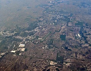
Marina Municipal Airport is a public airport located two miles (3 km) east of the central business district of Marina, a city in Monterey County, California, United States. It is owned by the City of Marina.
Mount Pleasant Municipal Airport is a city-owned public-use airport located two miles (3 km) northeast of the central business district of Mount Pleasant, a city in Isabella County, Michigan, United States. The airport became active in 1940. It serves general aviation for Mount Pleasant and the surrounding area. It is included in the Federal Aviation Administration (FAA) National Plan of Integrated Airport Systems for 2017–2021, in which it is categorized as a local general aviation facility.

George Field is a former World War II military airfield, located 5 miles east-northeast of Lawrenceville, Illinois. It operated as an advanced pilot training school for the United States Army Air Forces from 1942 until 1945.

Pekin Municipal Airport is a city-owned public-use airport located four nautical miles south of the central business district of Pekin, a city in Tazewell County, Illinois, United States. It is included in the FAA's National Plan of Integrated Airport Systems for 2011–2015, which categorized it as a general aviation facility.
Centralia Municipal Airport is a U.S. general aviation airport located two nautical miles southeast of Centralia, Illinois.
Jacksonville Municipal Airport is a civil, public-use airport located three miles (4.8 km) north of the town of Jacksonville, Illinois. The airport is publicly owned by the City of Jacksonville. The airport's first Master Plan was introduced in 1948.
Kewanee Municipal Airport is a civil, public use airport located 3 miles southwest of Kewanee, Illinois. The airport is publicly owned by the Kewanee Airport Authority.
Monmouth Municipal Airport is a civil, public use airport located two miles north of Monmouth, Illinois. The airport is publicly owned by the City of Monmouth.
Mount Sterling Municipal Airport is a public use airport located 2 miles west of Mount Sterling, Illinois. The airport is publicly owned.
Pontiac Municipal Airport is a public use airport 3 miles north of Pontiac in Livingston County, Illinois. The airport is publicly owned by the City of Pontiac.
Sparta Community Airport, also known as Hunter Field, is a civil, public use airport 2 miles north of Sparta in Randolph County, Illinois. The airport is publicly owned by the Sparta Community Airport Authority.
Vandalia Municipal Airport is a civil, public use airport located 3 miles northwest of Vandalia, Illinois. The airport is publicly owned by the Vandalia Park District, which also manages the fixed-base operator (FBO) on the field.
Dwight Airport is a public-use airport located three miles north of Dwight, Illinois. The airport is privately owned by the Dwight Aero Service.
Skylane Airport is a public use airport located 1 mile northwest of Evansville, Indiana. The airport is privately owned by the Skylane Pilots Association. It is 4 miles northeast of Evansville Regional Airport.
Marlette Township Airport is a public use airport located one mile southwest of Marlette, Michigan. The airport is publicly owned by Marlette Township.