Skipton is a market town and civil parish in North Yorkshire, England. Historically in the East Division of Staincliffe Wapentake in the West Riding of Yorkshire, it is on the River Aire and the Leeds and Liverpool Canal to the south of the Yorkshire Dales. It is situated 27 miles (43 km) north-west of Leeds and 38 miles (61 km) west of York. At the 2021 Census, the population was 14,623. The town has been listed as one of the best and happiest places to live in the UK.
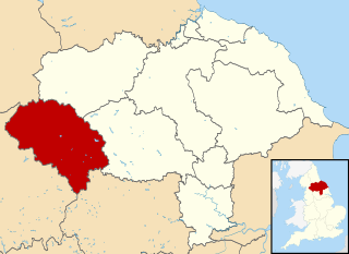
Craven was a non-metropolitan district in the west of North Yorkshire, centred on the market town of Skipton.

Barnoldswick is a market town and civil parish in the Borough of Pendle, in the administrative county of Lancashire, England. It is within the boundaries of the historic West Riding of Yorkshire. Barnoldswick and the surrounding areas of West Craven have been administered since 1974 as part of the modern administrative county of Lancashire. This was when West Riding County Council and Barnoldswick Urban District Council were abolished and the town was transferred to the Borough of Pendle.

Craven Arms is a market town and civil parish in Shropshire, England, on the A49 road and the Welsh Marches railway line, which link it north and south to the larger towns of Shrewsbury and Ludlow respectively. The Heart of Wales railway line joins the Welsh Marches line at Craven Arms and the town is served by Craven Arms railway station. The town is enclosed to the north by the Shropshire Hills Area of Outstanding Natural Beauty, and to the south is the fortified manor house of Stokesay Castle.
Uffington is a village and civil parish in Oxfordshire, about 4 miles (6.4 km) south of Faringdon and 6 miles (10 km) west of Wantage. The 2011 Census recorded the parish's population as 783. Lying within the historic county boundaries of Berkshire, in 1974 it was transferred for local government purposes to Oxfordshire under the Local Government Act 1972. Uffington is most commonly known for the Uffington White Horse hill figure on the Berkshire Downs in the south of the parish.
Hamstead Marshall is a village and civil parish in the English county of Berkshire. The village is located within the North Wessex Downs. The population of this civil parish at the 2011 census was 275.

Ingleton is a village and civil parish in the Craven district of North Yorkshire, England. The village is 19 miles (30 km) from Kendal and 17 miles (28 km) from Lancaster on the western side of the Pennines. It is 9.3 miles (15 km) from Settle. The River Doe and the River Twiss meet to form the source of the River Greta, a tributary of the River Lune. The village is on the A65 road and at the head of the A687. The B6255 takes the south bank of the River Doe to Ribblehead and Hawes. All that remains of the railway in the village is the landmark Ingleton Viaduct. Arthur Conan Doyle was a regular visitor to the area and was married locally, as his mother lived at Masongill from 1882 to 1917. It has been claimed that there is evidence that the inspiration for the name Sherlock Holmes came from here.

Stokesay is a village and former civil parish, now in the parish of Craven Arms, in the Shropshire district, in the ceremonial county of Shropshire, England. It is just south of Craven Arms on the A49 road, also fleetingly visible from the Shrewsbury to Hereford Welsh Marches railway line. In 1961 the parish had a population of 1217.

Earby is a town and civil parish within the Borough of Pendle, Lancashire, England. Although within the boundaries of the historic West Riding of Yorkshire, Earby has been administered by Lancashire County Council since 1974 and regularly celebrates its Yorkshire roots. It is 5 miles (8 km) north of Colne, 7 miles (11.3 km) south-west of Skipton, and 11 miles (17.7 km) north-east of Burnley. The parish had a population of 4,538 recorded in the 2011 census,
Steeton with Eastburn is a civil parish within the City of Bradford Metropolitan District, West Yorkshire, England. Historically part of the West Riding of Yorkshire, it has, according to the 2001 census, a population of 4,277, increasing to 4,375 at the 2011 Census. The parish includes the villages of Steeton and Eastburn.

Sutton-in-Craven is a village, electoral ward and a civil parish in the Craven district of North Yorkshire, England that is situated in the Aire Valley between Skipton and Keighley. Historically part of the West Riding of Yorkshire, in 2001 the population was 3,480, increasing to 3,714 at the Census 2011. The village is adjacent to Glusburn and Cross Hills, but although these three effectively form a small town, Sutton village maintains its distinct identity.

Gargrave is a large village and civil parish in the Craven district located along the A65, 4 miles (6 km) north-west of Skipton in North Yorkshire, England. It is situated on the very edge of the Yorkshire Dales. The River Aire and the Leeds and Liverpool Canal pass through the village. It had a population of 1,764 in 2001 reducing slightly to 1,755 at the 2011 census.
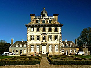
Ashdown House is a 17th-century country house in the civil parish of Ashbury in the English county of Oxfordshire. Until 1974 the house was in the county of Berkshire, and the nearby village of Lambourn remains in that county.
West Craven is an area in the east of Lancashire, England in the far northern part of the borough of Pendle. Historically the area was within the ancient county boundaries of Yorkshire and was administered as part of the Skipton Rural District of the West Riding of Yorkshire until 1974.

Eastburn is a village within the Steeton with Eastburn civil parish, in the City of Bradford Metropolitan District, West Yorkshire, England. The road through Eastburn is approximately 1/2 mile long and has a post office. The village also contains a school, a small chapel, a farm, a factory and a former mill building which houses many businesses.

Garford is a village and civil parish about 4 miles (6.4 km) west of Abingdon. It was part of Berkshire until the 1974 boundary changes transferred it to Oxfordshire. The parish is bounded by the River Ock to the north, by two tributaries of the Ock to the south, and by field boundaries and the road between Kingston Bagpuize and West Hanney to the west. The 2011 Census recorded the parish's population as 229.

Woolstone is a village and civil parish about 4+1⁄2 miles (7 km) south of Faringdon in the Vale of White Horse. Woolstone was part of Berkshire until the 1974 boundary changes transferred it to Oxfordshire. The 2011 Census recorded the parish population as 210.
Sparsholt is a village and civil parish about 3 miles (5 km) west of Wantage in the Vale of White Horse district of Oxfordshire. The parish includes the hamlet of Westcot about 1⁄2 mile (800 m) west of the village. Sparsholt was part of Berkshire until the 1974 boundary changes transferred the Vale of White Horse to Oxfordshire.

Steeton is a village in the City of Bradford metropolitan borough, West Yorkshire, England. Historically part of the West Riding of Yorkshire, it is situated approximately 5 miles (8 km) south-east from Skipton, 3 miles (5 km) north-west from Keighley and just south of the A629 road. The village is part of Steeton with Eastburn civil parish.
The Mainspring is a 1916 American silent drama film directed by Jack Conway and starring Ben F. Wilson, Wilbur Higby and Francelia Billington.