The Queen Elizabeth Range is a rugged mountain range of the Transantarctic Mountains System, located in the Ross Dependency region of Antarctica.
Alexandra Mountains is a group of low, separated mountains in the north portion of Edward VII Peninsula, just southwest of Sulzberger Bay in Marie Byrd Land, Antarctica. Discovered in January–February 1902 by the British National Antarctic Expedition during an exploratory cruise of the Discovery along the Ross Ice Shelf. Named for Alexandra, then Queen of the United Kingdom.
The Prince Charles Mountains are a major group of mountains in Mac. Robertson Land in Antarctica, including the Athos Range, the Porthos Range, and the Aramis Range. The highest peak is Mount Menzies. Other prominent peaks are Mount Izabelle and Mount Stinear. These mountains together with other scattered peaks form an arc about 260 miles long, extending from the vicinity of Mount Starlight in the north to Goodspeed Nunataks in the south.
Sibelius Glacier is a glacier, 12 miles (19 km) long and 6 miles (10 km) wide, flowing south into the Mozart Ice Piedmont 10 miles (16 km) southwest of Mount Stephenson situated in the northern portion of Alexander Island, Antarctica. The glacier was first sighted from the air by the British Graham Land Expedition in 1937. Mapped from air photos taken by the Ronne Antarctic Research Expedition in 1947-48, by Searle of the Falkland Islands Dependencies Survey in 1960. This feature was named by the United Kingdom Antarctic Place-Names Committee for Jean Sibelius (1865-1957), Finnish composer.
Meander Glacier is a large meandering tributary to Mariner Glacier in Victoria Land, Antarctica. The glacier emerges in the vicinity of Mount Supernal and Hobbie Ridge and drains generally eastward for 30 nautical miles (56 km) through the Mountaineer Range to join Mariner Glacier just east of Engberg Bluff. The descriptive name was given by the New Zealand Geological Survey Antarctic Expedition, 1962–63.
Mount Castro is a mountain, 1,630 metres (5,350 ft) high, on the north side of Seller Glacier, 5 nautical miles (9 km) southeast of Mount Gilbert, in the central Antarctic Peninsula. It was photographed from the air by the British Graham Land Expedition in 1937, and by the Ronne Antarctic Research Expedition in 1947. It was surveyed from the ground by the Falkland Islands Dependencies Survey in December 1958, and named by the UK Antarctic Place-Names Committee for João de Castro, a Portuguese navigator who made pioneer experimental investigations of the variation of the magnetic compass.

Dibble Glacier in Antarctica is a prominent channel glacier flowing from the continental ice and terminating in a prominent tongue at the east side of Davis Bay. It was delineated from air photos taken by U.S. Navy Operation Highjump (1946–47), and named by the Advisory Committee on Antarctic Names for Jonas Dibble, ship's carpenter on the sloop Peacock of the United States Exploring Expedition (1838–42) under Charles Wilkes. Dibble is credited with leaving his sick bed and working 24 hours without relief with other carpenters to repair a broken rudder on the Peacock, when the ship was partially crushed in an ice bay in 151°19′E and forced to retire northward.
Anchor Crag is a rocky crag on the north side of Airy Glacier, 4 nautical miles (7 km) north-northeast of Mount Gilbert, in the central part of the Antarctic Peninsula. It was photographed from the air by the Ronne Antarctic Research Expedition on November 27, 1947, and surveyed by the Falkland Islands Dependencies Survey, November 4, 1958. The United Kingdom Antarctic Place-Names Committee name is descriptive of a snow patch lodged on the face of the rock which, in 1958, closely resembled a ship's anchor.

Anthony Glacier is a glacier which flows in an east-southeast direction to the east coast of Palmer Land where it terminates opposite the south tip of Hearst Island. The upper part of this glacier was seen by a sledge party of the British Graham Land Expedition under John Riddoch Rymill in 1936–37. The glacier was seen from the seaward side in 1940 by a sledging party from the East Base of the United States Antarctic Service, and in 1947 was photographed from the air by the Ronne Antarctic Research Expedition (RARE). It was named by Finn Ronne for Alexander Anthony of the J.P. Stevens Company, New York City, which contributed windproof clothing to the RARE.
Bevin Glacier is a glacier 5 nautical miles (9 km) long, which flows east from the plateau escarpment on the east side of Graham Land into the northwest end of Cabinet Inlet between Attlee Glacier and Anderson Glacier. During December 1947 it was charted by the Falkland Islands Dependencies Survey (FIDS) and photographed from the air by the Ronne Antarctic Research Expedition. It was named by the FIDS for Rt. Hon. Ernest Bevin, M.P., British Minister of Labour and National Service and member of the War Cabinet.

Bussey Glacier is a glacier flowing west from Mount Peary to the head of Waddington Bay on Kiev Peninsula on the west coast of Graham Land. It was first charted by the French Antarctic Expedition under Jean-Baptiste Charcot, 1908–10, and named by the UK Antarctic Place-Names Committee in 1959 for Group Captain John Bussey of the Directorate of Overseas Surveys.
Cornwall Glacier is a glacier 9 nautical miles (17 km) long, flowing south from Crossover Pass in the Shackleton Range to join Recovery Glacier east of Ram Bow Bluff. It was first mapped in 1957 by the Commonwealth Trans-Antarctic Expedition, and named for General Sir James Handyside Marshall-Cornwall, a member of the Committee of Management of the Commonwealth Trans-Antarctic Expedition, 1955–58.
Mount Dudley is a mountain over 1,375 metres (4,510 ft) high, standing at the head of Neny Fjord and bounded on the north and east sides by Neny Glacier, on the west coast of Graham Land. The west side of this mountain was first roughly surveyed in 1936 by the British Graham Land Expedition under John Rymill. It was surveyed in entirety in 1940 by the United States Antarctic Service. The feature was photographed from the air and ground by the Ronne Antarctic Research Expedition (RARE) of 1947–48 under Finn Ronne, who named it for Harold M. Dudley, the executive secretary of the American Council of Commercial Laboratories, Inc. in Washington, D.C. who procured various types of equipment and arranged financial aid for RARE.

Moran Glacier is a glacier 10 nautical miles (18 km) long, joined at the south side by Walter Glacier, flowing east into Schokalsky Bay, situated in the northeast portion of Alexander Island, Antarctica. Photographed from the air by Ronne Antarctic Research Expedition (RARE), 1947–48, and surveyed by Falkland Islands Dependencies Survey (FIDS), 1948-50. Named by Advisory Committee on Antarctic Names (US-ACAN) for Commander Clifford D. Moran, U.S. Navy, aircraft pilot, Squadron VXE-6, U.S. Navy Operation Deep Freeze, 1966 and 1977.
Hariot Glacier is a glacier flowing northwest along the south side of Morgan Upland before turning west into the northern portion of the Wordie Ice Shelf, along the west coast of the Antarctic Peninsula. It was roughly surveyed by the British Graham Land Expedition, 1936–37, and the upper reaches were photographed from the air by the Ronne Antarctic Research Expedition, 1947. The glacier was surveyed from the ground by members of the Falkland Islands Dependencies Survey who travelled along it in December 1958, and it was named by the UK Antarctic Place-Names Committee after Thomas Hariot, an English mathematician who pioneered new methods of navigation under the patronage of Sir Walter Raleigh.

Heitō Glacier is a small glacier draining westward along the south side of Mount Heitō in the southern part of the Langhovde Hills, Queen Maud Land, Antarctica. It was mapped from surveys and air photos by the Japanese Antarctic Research Expedition (JARE), 1957–62, and was named Heitō-hyoga for its proximity to Mount Heitō by JARE Headquarters in 1973.
Hewitt Glacier is a glacier, 15 nautical miles (28 km) long, descending the eastern slopes of the Holland Range, Antarctica, between Lewis Ridge and Mount Tripp to enter Richards Inlet. It was named by the New Zealand Geological Survey Antarctic Expedition (1959–60) for Leonard R. Hewitt, leader at Scott Base, 1959.

Mackenzie Glacier is a glacier 4 nautical miles (7 km) long flowing eastward from Mount Parry to join Malpighi Glacier at the east coast of Brabant Island, in the Palmer Archipelago, Antarctica. It was first roughly charted by the Belgian Antarctic Expedition, 1897–99, under Gerlache, was photographed by Hunting Aerosurveys Ltd in 1956–57, and was mapped from these photos in 1959. The glacier was named by the UK Antarctic Place-Names Committee for English physician Sir James Mackenzie, a pioneer of studies of heart disease.
Roos Glacier is a steep glacier that drains the northwest slopes of Mount Murphy on Walgreen Coast, Marie Byrd Land. Named by Advisory Committee on Antarctic Names (US-ACAN) after S. Edward Roos, oceanographer with the Byrd Antarctic Expeditions of 1928-30 and 1933-35. Buettner Peak is a sharp peak rising midway along the north wall of Roos Glacier.
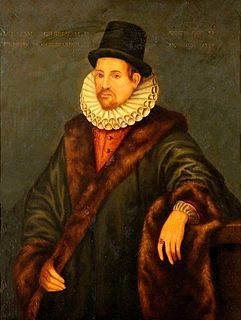
Rotz Glacier is a tributary glacier 9 nautical miles (17 km) long and 2 nautical miles (3.7 km) wide. It flows west from Wakefield Highland, central Antarctic Peninsula, into Airy Glacier at a point due south of Mount Timosthenes. Photographed by Ronne Antarctic Research Expedition (RARE) on November 27, 1947. Surveyed by Falkland Islands Dependencies Survey (FIDS) in December 1958 and November 1960. Named by United Kingdom Antarctic Place-Names Committee (UK-APC) after Jean Rotz, 16th century French chartmaker and writer on the principles of navigation, who designed an elaborate magnetic compass and became hydrographer to King Henry VIII in 1542.