
The Santa Cruz Mountains, part of the Pacific Coast Ranges, are a mountain range in central and Northern California, United States. They form a ridge down the San Francisco Peninsula, south of San Francisco. They separate the Pacific Ocean from the San Francisco Bay and the Santa Clara Valley, and continue south to the Central Coast, bordering Monterey Bay and ending at the Salinas Valley. The range passes through the counties of San Mateo, Santa Clara, Santa Cruz, San Benito and Monterey, with the Pajaro River forming the southern boundary.

Mount McLoughlin is a dormant steep-sided stratovolcano, or composite volcano, in the Cascade Range of southern Oregon and within the United States Sky Lakes Wilderness. It is one of the volcanic peaks in the Cascade Volcanic Arc, within the High Cascades sector. A prominent landmark for the Rogue River Valley, the mountain is north of Mount Shasta, and south-southeast of Crater Lake. It was named around 1838 after John McLoughlin, a Chief Factor for the Hudson's Bay Company. Mount McLouglin's prominence has made it a landmark to Native American populations for thousands of years.

Snowbird is an unincorporated community in Little Cottonwood Canyon in the Wasatch Range of the Rocky Mountains near Salt Lake City, Utah, United States. It is most famous for Snowbird Ski and Summer Resort, an alpine skiing and snowboarding area, which opened in December 1971.

Mount Hamilton is a mountain in the Diablo Range in Santa Clara County, California. The mountain's peak, at 4,265 feet (1,300 m), overlooks the heavily urbanized Santa Clara Valley and is the site of Lick Observatory, the world's first permanently occupied mountain-top observatory. The asteroid 452 Hamiltonia, discovered in 1899, is named after the mountain. Golden eagle nesting sites are found on the slopes of Mount Hamilton. On clear days, Mount Tamalpais, the Santa Cruz Mountains, Monterey Bay, the Monterey Peninsula, and even Yosemite National Park are visible from the summit of the mountain.

The Santa Catalina Mountains, commonly referred to as the Catalina Mountains or the Catalinas, are north and northeast of Tucson in Arizona, United States, on Tucson's north perimeter. The mountain range is the most prominent in the Tucson area, with the highest average elevation. The highest point in the Catalinas is Mount Lemmon at an elevation of 9,157 feet (2,791 m) above sea level and receives 18 inches (46 cm) of precipitation annually.

Mount Lemmon, with a summit elevation of 9,159 feet (2,792 m), is the highest point in the Santa Catalina Mountains. It is located in the Coronado National Forest north of Tucson, Arizona, United States. Mount Lemmon was named for botanist Sara Plummer Lemmon, who trekked to the top of the mountain with her husband and E. O. Stratton, a local rancher, by horse and foot in 1881. Mount Lemmon is also known as Babad Do'ag, or Frog Mountain to the Tohono O'odham.
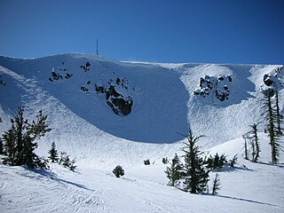
Mount Ashland ski area is located on 7,532-foot (2,296 m) Mount Ashland and features 23 trails on 200 acres (0.81 km2) served by four lifts, in addition to chute skiing in a glacial cirque called The Bowl. The mountain receives over 225" of snow annually, with a season from early December until mid-April. Half of the terrain is rated as advanced, and 15% is rated beginner.

Whiteface Mountain is the fifth-highest mountain in the U.S. state of New York, and one of the High Peaks of the Adirondack Mountains. Set apart from most of the other High Peaks, the summit offers a 360-degree view of the Adirondacks and clear-day glimpses of Vermont and even Canada, where the skyscrapers of Montreal, 80 miles (130 km) away, can be seen on a very clear day. Located in the town of Wilmington, about 13 miles (21 km) from Lake Placid, the mountain's east slope is home to a major ski area with the greatest vertical drop east of the Rockies, which hosted the alpine skiing competitions of the 1980 Winter Olympics. Unique among the High Peaks, Whiteface features a developed summit and seasonal accessibility by motor vehicle. Whiteface Memorial Highway reaches a parking area at an elevation of 4,600 feet (1,400 m), with the remaining 267 feet (81 m) being obtained by tunnel and elevator.

Summerhaven is a small unincorporated community and census-designated place (CDP) on Mount Lemmon in the Santa Catalina Mountains north of Tucson in Pima County, Arizona, United States. As of the 2010 census it had a permanent population of 40. Summerhaven sits at an elevation of approximately 7,600 to 8,200 feet above sea level. Summerhaven is accessed via the Catalina Highway from suburban northeast Tucson, and it is about 24.5 miles (39.4 km) from the base of the mountains to Summerhaven.
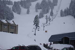
Mount Bachelor ski resort is a ski resort located in Central Oregon, approximately 22 miles (35 km) west of Bend, along Century Drive Highway. The ski area is on the northern side of Mount Bachelor, a stratovolcano rising atop a volcanic shield in the Cascade Range.
The Catalina Highway, officially the General Hitchcock Highway, is the popular name for a Forest Highway and scenic route located in Pima County in southern Arizona. Also known as the Sky Island Scenic Byway, the Mount Lemmon Highway and Arizona Forest Highway 39, the Catalina Highway is the only paved roadway providing access to the resort village of Summerhaven as well as various recreational and scientific facilities located near the summit of Mount Lemmon. Ascending from the desert floor in Tucson to near the summit of Mount Lemmon, the short highway gains over 6,000 ft (1.8 km), showcasing a variety of climates ranging from lowland desert to alpine forests. The name sky island comes from the analogy of these mountains being like islands of forest in a sea of desert. It is designated as a scenic byway by the National Scenic Byways Program. and an Arizona Scenic Road by the Federal Highway Administration.

Mount Pinos is a mountain located in the Los Padres National Forest on the boundary between Ventura and Kern counties in California. The summit, at 8,847 feet (2,697 m), is the highest point in Ventura County. The mountain is the highest point of the Transverse Ranges west of Tejon Pass, as well as the southernmost point of the Salinian Block.

Sugarbush Resort is a ski resort located in the Mad River valley in Warren, Vermont, owned by Alterra Mountain Company. It is one of the largest ski resorts in New England. The resort encompasses more than 4000 acres (16 km²) total, 484 trail acres (2.34 km²) skiable, 53 miles (85 km) of trails, and 16 ski lifts. Sugarbush has 111 ski trails, 18 additional marked wooded area, substantial off-piste skiing and riding, a summit elevation of 4,083 ft (1,244 m), and a vertical drop of 2,600 feet (790 m), second largest in Vermont after Killington, and the third largest in New England after Killington and Sugarloaf.
Mount Waterman is a ski area on Waterman Mountain in the San Gabriel Mountains of the Angeles National Forest in Los Angeles County, California. The area is located on California State Route 2, the Angeles Crest Highway, and reaches a height of 8,030 ft (2,450 m) with an overall vertical drop of 1,030 ft (310 m). Mount Waterman is leased under a special use permit from the United States Forest Service. Skiable terrain is distributed as: 20% beginner, 20% intermediate, and 60% advanced.

Sunrise Park Resort is an alpine ski resort located near Greer, Arizona. The resort consists of three mountains named Sunrise Peak, Cyclone Circle, and Apache Peak. Situated on the Colorado Plateau and perched atop the White Mountains in eastern Arizona. The base of the resort sits at 9,200 feet (2,800 m) and the tallest mountain, Apache Peak, tops out at an elevation of 11,000 feet (3,400 m) above sea level. The ski slopes spread across the 3 peaks and cover 1,200 acres (4.9 km2), making it the largest ski resort in Arizona.

Sandia Peak Ski Area, originally La Madera Ski Area, is a ski resort located in the Sandia Mountains in northeast Bernalillo County, New Mexico, United States, immediately northeast of the city of Albuquerque. It is part of a Special Use Permit Zone in the Sandia Ranger District of the Cibola National Forest. It is New Mexico's first ski area, opening to skiers in 1936. It features Sandia Peak Tramway, which was until 2010 the longest tramway in the world, and remains the longest in the Americas. The resort includes 35 ski runs and a terrain park, and also serves as a site for summer recreation. It is one of the few ski resorts in the US that can be directly accessed from a major city.

Ski Santa Fe or Santa Fe Ski Basin is a major ski resort located in the Sangre de Cristo Mountains in Santa Fe County, New Mexico, United States, 16 miles east of the state capital of Santa Fe. It includes 7 lifts and 86 runs at elevations of over 10,000 feet (3,000 m). It is the southernmost major ski resort of the Rocky Mountains, and one of the oldest and highest in the nation.

Mount Lincoln is an 8,383-foot-elevation (2,555 meter) mountain summit in Placer County, California, United States.

Mount Judah is an 8,243-foot-elevation (2,512 meter) mountain summit in Placer County, California, United States.


