
The geography of Mozambique consists mostly of coastal lowlands with uplands in its center and high plateaus in the northwest. There are also mountains in the western portion. The country is located on the east coast of southern Africa, directly west of the island of Madagascar. Mozambique has a tropical climate with two seasons, a wet season from October to March and a dry season from April to September.

Malawi is a landlocked country in southeast Africa. It is wholly within the tropics; from about 9°30S at its northernmost point to about 17°S at the southernmost tip. The country occupies a thin strip of land between Zambia and Mozambique, extending southwards into Mozambique along the valley of the Shire River. In the north and north east it also shares a border with Tanzania. Malawi is connected by rail to the Mozambican ports of Nacala and Beira. It lies between latitudes 9° and 18°S, and longitudes 32° and 36°E.

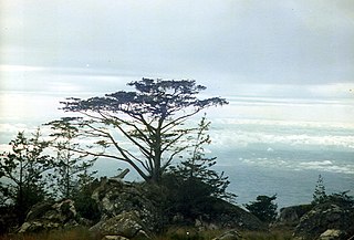
The Eastern Highlands, also known as the Manica Highlands, is a mountain range on the border of Zimbabwe and Mozambique. The Eastern Highlands extend north and south for about 300 kilometres (190 mi) through Zimbabwe's Manicaland Province and Mozambique's Manica Province.

The Sierras de Córdoba is a mountain range in central Argentina, located between the Pampas to the east and south and the Chaco to the north and east. Most of the range is located in Córdoba Province, except for the southwestern margin which is in San Luis Province.

The Ethiopian Highlands is a rugged mass of mountains in Ethiopia in Northeast Africa. It forms the largest continuous area of its elevation in the continent, with little of its surface falling below 1,500 m (4,900 ft), while the summits reach heights of up to 4,550 m (14,930 ft). It is sometimes called the "Roof of Africa" due to its height and large area. It is the only country in the region with such a high elevated surface. This elevated surface is bisected diagonally by the Great East African Rift System which extends from Syria to Mozambique across the East African Lakes. Most of the Ethiopian Highlands are part of central and northern Ethiopia, and its northernmost portion reaches into Eritrea.

The Narmada Valley dry deciduous forests are a tropical dry forest ecoregion of central India. The ecoregion lies mostly in Madhya Pradesh state, but extends into portions of Chhattisgarh, Maharashtra, Karnataka and Uttar Pradesh states.

The Coast Range ecoregion is a Level III ecoregion designated by the Environmental Protection Agency (EPA) in the U.S. states of Washington, Oregon, and California. It stretches along the Pacific Coast from the tip of the Olympic Peninsula in the north to the San Francisco Bay in the south, including Grays Harbor, Willapa Bay, and the Long Beach Peninsula in Washington, the entire length of the Oregon Coast, and the Northern California Coast. Named for the Coast Range mountains, it encompasses the lower elevations of the Olympic Mountains, the Oregon Coast Range, the Californian North Coast Ranges, and surrounding lowlands.

The Cascades ecoregion is a Level III ecoregion designated by the United States Environmental Protection Agency (EPA) in the U.S. states of Washington, Oregon, and California. Somewhat smaller than the Cascade mountain range for which it is named, the ecoregion extends north to Snoqualmie Pass, near Seattle, and south to Hayden Pass, near the Oregon-California border, including the peaks and western slopes of most of the High Cascades. A discontiguous section is located on Mount Shasta in California.

The Eastern Cascades Slopes and Foothills ecoregion is a Level III ecoregion designated by the United States Environmental Protection Agency (EPA) in the U.S. states of Oregon, Washington, and California. In the rain shadow of the Cascade Range, the eastern side of the mountains experiences greater temperature extremes and receives less precipitation than the west side. Open forests of ponderosa pine and some lodgepole pine distinguish this region from the Cascades ecoregion, where hemlock and fir forests are more common, and from the lower, drier ecoregions to the east, where shrubs and grasslands are predominant. The vegetation is adapted to the prevailing dry, continental climate and frequent wildfire. Volcanic cones and buttes are common in much of the region.
The South Malawi montane forest–grassland mosaic is an ecoregion of Malawi.

The Southern Zanzibar–Inhambane coastal forest mosaic, also known as the Southern Swahili coastal forests and woodlands, is a tropical moist broadleaf forest ecoregion of eastern Africa. It is a southern variation of Northern Zanzibar-Inhambane coastal forest mosaic. The ecoregion supports habitats of forest, savanna and swamps. The southern portion of the ecoregion is not as well studied due to the 1977-1992 civil war in Mozambique.
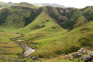
The Southern Highlands is a highland region in southwestern Tanzania, at the northern end of Lake Malawi. The highlands include portions of Mbeya, Njombe, Rukwa, Ruvuma, and Songwe regions, bordering Malawi, Mozambique, and Zambia. Mbeya is the largest city in the highlands.
The Chimanimani Mountains are a mountain range on the border of Zimbabwe and Mozambique. The mountains are in the southern portion of the Eastern Highlands, or Manica Highlands, a belt of highlands that extend north and south along the international border, between the Zambezi and Save rivers.

Mount Gorongosa is an inselberg in Sofala Province of central Mozambique. Its highest peak, Gogogo, reaches an elevation of 1,863 meters. It was created by Karoo Volcanism.
Mount Chiperone is a mountain in northern Mozambique. It lies in Milange District of Zambézia Province, 40 km SSW of the town of Milange.
The Cheringoma Plateau is a low plateau in Sofala Province of Mozambique. It lies mostly within Cheringoma, Muanza, and Marromeu districts.
The Umalila Mountains are a mountain range in southern Tanzania, on the border with Malawi. The Umalila Mountains are part of Tanzania's Southern Highlands.
The Rubeho Mountains are a mountain range in central Tanzania. The mountains in Dodoma and Morogoro regions, southeast of Tanzania's capital Dodoma. The Rubeho Mountains are part of the Eastern Arc Mountains, and are home to a biodiverse community of flora and fauna with large numbers of endemic species.
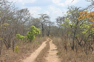
The Southern miombo woodlands is a tropical grasslands and woodlands ecoregion extending across portions of Malawi, Mozambique, Zambia, and Zimbabwe.
The Urema Valley, also known as the Urema Graben, is a lowland valley in Sofala Province of central Mozambique.
