Mount Narryer

Last updated

Mount Narryer
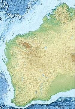
Australia Western Australia relief location map.png
Red triangle with thick white border.svg
Mount Narryer
Location in Western Australia
Highest point
Elevation 469 m (1,539 ft) [1]
Coordinates 26°31′22″S116°22′51″E / 26.522889°S 116.3807861°E / -26.522889; 116.3807861
Geography
Location Mid West region of Western Australia
Parent range Hamersley Range

Mount Narryer is a mountain in Western Australia.

It is located about 208 kilometres (129 mi) north of Yalgoo and 214 kilometres (133 mi) north east of Kalbarri in the Mid West region of Western Australia. Situated along the Murchison River, [2] the mountain is surrounded by mulga scrubland.

The mountain itself is a fin shaped rocky outcrop 27 kilometres (17 mi) long and 3 kilometres (2 mi) wide, and juts out from the red sandy desert floor. [3]

Mount Narryer is within the boundaries of Mount Narryer Station, which was established in about 1880. [4]

Tiny fragments of zircon collected from Mount Narryer and the nearby Jack Hills have been dated at over four billion years old. [5]
See also

Related Research Articles

<span class="mw-page-title-main">Outback</span> Area in Australia

The Outback is a remote, vast, sparsely populated area of Australia. The Outback is more remote than the bush. While often envisaged as being arid, the Outback regions extend from the northern to southern Australian coastlines and encompass a number of climatic zones, including tropical and monsoonal climates in northern areas, arid areas in the "red centre" and semi-arid and temperate climates in southerly regions.

<span class="mw-page-title-main">Great Western Tiers</span> Mountain range in Tasmania, Australia

The Great Western Tiers are a collection of mountain bluffs that form the northern edge of the Central Highlands plateau in Tasmania, Australia. The bluffs are contained within the Tasmanian Wilderness World Heritage Site.

<span class="mw-page-title-main">Stirling Range</span> Mountain range in Great Southern region of Western Australia

The Stirling Range or Koikyennuruff is a range of mountains and hills in the Great Southern region of Western Australia, 337 kilometres (209 mi) south-east of Perth. It is over 60 kilometres (37 mi) wide from west to east, stretching from the highway between Mount Barker and Cranbrook eastward past Gnowangerup. The Stirling Range is protected by the Stirling Range National Park, which was gazetted in 1913, and has an area of 1,159 km2 (447 sq mi).

<span class="mw-page-title-main">Yaraka</span> Town in Queensland, Australia

Yaraka is a rural town and locality in the Longreach Region of Queensland, Australia. Until 2021, the town of Yaraka was part of the locality of Isisford.

<span class="mw-page-title-main">Cameron Corner, Queensland</span> Suburb of Bulloo Shire, Queensland, Australia

Cameron Corner is an outback locality in the Shire of Bulloo, Queensland, Australia. In the 2016 census, Cameron Corner had a population of 5 people. It borders New South Wales to the south and South Australia to the west.

<span class="mw-page-title-main">Pardoo Station</span> Pastoral lease in Western Australia

Pardoo Station is a pastoral lease, formerly a sheep station, and now a cattle station approximately 120 kilometres (75 mi) east of Port Hedland and 121 kilometres (75 mi) north of Marble Bar, in the Pilbara region of Western Australia.

<span class="mw-page-title-main">Bulgunnia Station</span>

Bulgunnia Station is a 3,200 square kilometres (1,236 sq mi) sheep station in north-western South Australia.

<span class="mw-page-title-main">Cordillo Downs</span>

Cordillo Downs or Cordillo Downs Station is both a pastoral lease currently operating as a cattle station and a formal bounded locality in South Australia. It is located about 116 kilometres (72 mi) north of Innamincka and 155 kilometres (96 mi) south east of Birdsville. The name and boundaries of the locality were created on 26 April 2013 for the long established local name.

<span class="mw-page-title-main">Durrie Station</span> Pastoral lease and cattle station in Queensland

Durrie Station is a pastoral lease that operates as a cattle station in Queensland, Australia.

Morney Plains Station, most commonly referred to as Morney Plains, is a pastoral lease that operates as a cattle station in south west Queensland.

Bonney Downs Station is a pastoral lease that was once a sheep station but now operates as a cattle station in Western Australia.

References

  1. "Mount Narryer". Bonzle. 2014. Retrieved 2 April 2014.
  2. "Station owners sandbagging and raising levees". The West Australian. Yahoo7. 23 February 2011. Retrieved 1 April 2014.
  3. Graham Lloyd (22 February 2014). "Wild Australia: The outback mountain 4 billion years old". The Australian. News Limited.
  4. "Narryer Station". Western Mail . Perth, Western Australia: National Library of Australia. 18 June 1925. p. 35. Retrieved 1 April 2014.
  5. Graham Lloyd (22 February 2014). "Wild Australia: The outback mountain 4 billion years old". The Australian. News Limited . Retrieved 2 April 2014.