The Scaife Mountains is a group of mountains rising west of Prehn Peninsula and between the Ketchum and Ueda glaciers, in Palmer Land, at the base of Antarctic Peninsula.
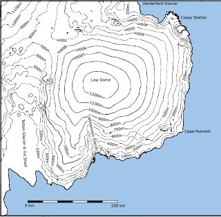
Law Dome is a large ice dome which rises to 1,395 metres (4,580 ft) directly south of Cape Poinsett, Antarctica. The feature was roughly mapped by the United States Geological Survey from aerial photographs taken by U.S. Navy Operation Highjump, 1946–47, and has been the subject of intensive glaciological and geophysical surveys by Australian National Antarctic Research Expeditions between 1962 and 1965. It was named by the Antarctic Names Committee of Australia for Phillip Law, Director of the Australian Antarctic Division from 1949 to 1966.
Young Nunataks is a group of nunataks in the Napier Mountains standing 2 nautical miles (3.7 km) south of Mount Elkins, Antarctica. Mapped by Norwegian cartographers from aerial photos taken by the Lars Christensen Expedition, 1936–37. Remapped from aerial photos taken by ANARE in 1956 and named for W.F. Young, electrical fitter at Mawson Station in 1961.

Posadowsky Glacier is a glacier about 9 nautical miles long, flowing north to Posadowsky Bay immediately east of Gaussberg. Posadowsky Bay is an open embayment, located just east of the West Ice Shelf and fronting on the Davis Sea in Kaiser Wilhelm II Land. Kaiser Wilhelm II Land is the part of East Antarctica lying between Cape Penck, at 87°43'E, and Cape Filchner, at 91°54'E, and is claimed by Australia as part of the Australian Antarctic Territory. Other notable geographic features in this area include Drygalski Island, located 45 mi NNE of Cape Filchner in the Davis Sea, and Mirny Station, a Russian scientific research station.
On the continent of Antarctica, the Aramis Range is the third range south in the Prince Charles Mountains, situated 11 miles southeast of the Porthos Range and extending for about 30 miles in a southwest–northeast direction. It was first visited in January 1957 by Australian National Antarctic Research Expeditions (ANARE) southern party led by W.G. Bewsher, who named it for a character in Alexandre Dumas' novel The Three Musketeers, the most popular book read on the southern journey.
Watts Needle is a needle-shaped peak (1,450 m) at the southwest end of the ridge east of Glen Glacier, in the Read Mountains, Shackleton Range. It was photographed from the air by the U.S. Navy in 1967 and was surveyed by the British Antarctic Survey (BAS) from 1968 to 1971. In association with the names of geologists grouped in this area, it was named by the United Kingdom Antarctic Place-Names Committee (UK-APC) in 1971 after William Whitehead Watts (1860–1947), a British geologist who worked particularly on the Precambrian rocks of the English midlands. Watts was also a professor of geology at the Imperial College in London from 1906 to 1930.
Cumpston Glacier is a small glacier on the east coast of Graham Land, draining between Breitfuss Glacier and Quartermain Glacier into the head of Mill Inlet. It was named by the UK Antarctic Place-Names Committee for J.S. Cumpston, an Australian historian of the Antarctic.
Visser Hill is a hill 2.5 nautical miles (4.6 km) south of Mount Velain in northern Adelaide Island. Mapped from air photos taken by Ronne Antarctic Research Expedition (RARE) (1947–48) and Falkland Islands and Dependencies Aerial Survey Expedition (FIDASE) (1956–57). Named by United Kingdom Antarctic Place-Names Committee (UK-APC) for Philipp C. Visser (1882–1955), Dutch diplomat and mountaineer who made classic investigations of glaciers in the Karakoram (1921–35).
Mount Griffiths is an elongated mountain with two prominent peaks of 1,650 and 1,680 metres, standing 5 miles (8 km) northwest of the Wilkinson Peaks and 23 kilometres (14 mi) northwest of Mount Elkins in the Napier Mountains of Enderby Land, Antarctica.
Pythagoras Peak is the highest peak, 1,275 m, in the central Tula Mountains, standing along the north side of Beaver Glacier, 8 nautical miles (15 km) southeast of Mount Storer. The peak has a prominent notch, the eastern aspect being a right-angled triangle with a perpendicular northern face. It was photographed from Mount Riiser-Larsen in February 1958 by ANARE led by Phillip Law, but was first visited and surveyed in December 1958 by G.A. Knuckey, ANARE surveyor. It was named by the Antarctic Names Committee of Australia (ANCA) after Pythagoras, Greek philosopher, whose theorem concerning a right-angled triangle is well known.
Patterson Peak is a peak, 1,610 m, standing at the south end of Medina Peaks, 4 nautical miles (7 km) northwest of Anderson Ridge, in the Queen Maud Mountains of Antarctica. Mapped by United States Geological Survey (USGS) from ground surveys and U.S. Navy air photos, 1960–64. Named by Advisory Committee on Antarctic Names (US-ACAN) for Clair C. Patterson, glaciologist at Byrd Station, summer 1965–66.
Mount Metcalfe is a mountain at the south side of the head of McMorrin Glacier, 1.5 nautical miles (3 km) south of Mount Wilcox, in Graham Land, Antarctica. It was named by the UK Antarctic Place-Names Committee for Robert J. Metcalfe, a British Antarctic Survey surveyor at Stonington Island, 1960–62, who surveyed the area in 1962.

Marret Glacier is a channel glacier about 4 nautical miles (7 km) wide and 4 nautical miles long, flowing northeast from the continental ice of Antarctica to the coast close east of Cape Robert. It was delineated from aerial photos taken by U.S. Navy Operation Highjump, 1946–47, and was named by the Advisory Committee on Antarctic Names for Mario Marret, the leader of the French Antarctic Expedition, 1952–53, whose party extended reconnaissance of the coastal features to the west side of Victor Bay.
Mount Mateer is a mountain 1 nautical mile (2 km) east of Mount Degerfeldt, in the Tula Mountains in Enderby Land, Antarctica. It was plotted from air photos taken from Australian National Antarctic Research Expeditions aircraft in 1956 and 1957 and was named by the Antarctic Names Committee of Australia for N.C. Mateer, a member of the crew of the Discovery during the British Australian New Zealand Antarctic Research Expedition of 1929–31.
Mount Selwood is a mountain 5 nautical miles (9 km) northeast of Pythagoras Peak, in the Tula Mountains in Enderby Land. It was plotted from air photos taken from ANARE aircraft in 1956 and was named by the Antarctic Names Committee of Australia (ANCA) for C.H.V. Selwood, a member of the crew of the Discovery during the British Australian New Zealand Antarctic Research Expedition (BANZARE) of 1929–31.

Sleipnir Glacier is a glacier 10 nautical miles (18 km) long, flowing into the west side of Cabinet Inlet between Balder and Spur Points, on the east coast of Graham Land, Antarctica. The Vologes Ridge is in the central portion of the glacier.
Mount Torckler is a mountain 3 nautical miles (6 km) southeast of Mount Smethurst and 28 nautical miles (50 km) southwest of Stor Hanakken Mountain in Enderby Land. It was plotted from air photos taken from ANARE aircraft in 1957 and was named by the Antarctic Names Committee of Australia (ANCA) for R.M. Torckler, a radio officer at Wilkes Station in 1961.
Vapour Col is a col lying south of Stonethrow Ridge on the west side of Deception Island in the South Shetland Islands of Antarctica. The name given by the United Kingdom Antarctic Place-Names Committee (UK-APC) in 1959 originates from the fumaroles in the col. This is the only locality on Deception Island where there is a complete cross section through the stratigraphy of volcanic succession. Having a similar name in the same island is the Fumarole Bay.