
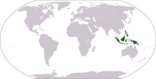
Indonesia is an archipelagic country located in Southeast Asia, lying between the Indian Ocean and the Pacific Ocean. It is located in a strategic location astride or along major sea lanes connecting East Asia, South Asia and Oceania. Indonesia is the largest archipelago in the world. Indonesia's various regional cultures have been shaped—although not specifically determined—by centuries of complex interactions with its physical environment.

Sulawesi, also known as Celebes, is an island in Indonesia. One of the four Greater Sunda Islands, and the world's eleventh-largest island, it is situated east of Borneo, west of the Maluku Islands, and south of Mindanao and the Sulu Archipelago. Within Indonesia, only Sumatra, Borneo, and Papua are larger in territory, and only Java and Sumatra have larger populations.
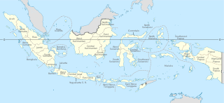
Provinces of Indonesia are the 38 administrative divisions of Indonesia and the highest tier of the local government. Provinces are further divided into regencies and cities, which are in turn subdivided into districts (kecamatan).

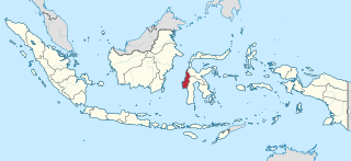
Central Sulawesi is a province of Indonesia located at the centre of the island of Sulawesi. The administrative capital and largest city is located in Palu. The 2010 census recorded a population of 2,635,009 for the province, and the 2020 Census recorded 2,985,734, of whom 1,534,706 were male and 1,451,028 were female. The official estimate as at mid 2022 was 3,066,143. Central Sulawesi has an area of 61,605.72 km2 (23,786 sq mi), the largest area among all provinces on Sulawesi Island, and has the second-largest population on Sulawesi Island after the province of South Sulawesi. It is bordered by the provinces of Gorontalo to the north, West Sulawesi, South Sulawesi and South East Sulawesi to the south, by Maluku to the east, and by the Makassar Strait to the west. The province is inhabited by many ethnic groups, such as the Kaili, Tolitoli, etc. The official language of the province is Indonesian, which is used for official purposes and inter-ethnic communication, while there are several indigenous language spoken by the Indigenous peoples of Central Sulawesi. Islam is the dominant religion in the province, followed by Christianity which is mostly adhered to by the people in the eastern part of the province.

North Sulawesi is a province of Indonesia. It is located on the Minahasa Peninsula of the island of Sulawesi, south of the Philippines and southeast of Sabah, Malaysia. It borders the Philippine province of Davao Occidental and Soccsksargen regions of the Philippines to the north, the Maluku Sea to the east, Gorontalo and Celebes Sea to the west and the Gulf of Tomini to the southwest. With the outlying island of Miangas to its north, it is the northernmost province of Indonesia. The province's area is 14,500.28 square kilometres (5,598.59 sq mi), and its population was 2,270,596 according to the 2010 census; this rose to 2,621,923 at the 2020 Census, while the official estimate as at mid 2022 was 2,659,543.
The Malay Archipelago also called Insulindia or the Indo-Australian Archipelago is the archipelago between Mainland Southeast Asia and Australia. It has also been called the "Malay world," "Nusantara", "East Indies" and other names over time. The name was taken from the 19th-century European concept of a Malay race, later based on the distribution of Austronesian languages.
West Sulawesi is a province of Indonesia. It is located on the western side of Sulawesi island. It covers an area of 16,594.75 km2, and its capital is the town of Mamuju. The 2010 Census recorded a population of 1,158,651, while that in 2020 recorded 1,419,228; the official estimate as at mid 2022 was 1,458,606.

Parepare is a city (kota) in South Sulawesi, Indonesia, located on the southwest coast of Sulawesi, about 155 km (96 mi) north of the provincial capital of Makassar. A port town, it is one of the major population centers of the Bugis people. The city had a population of 129,542 people at the 2010 Census and 151,454 at the 2020 Census.
Latimojong, also known by its peak name Rantemario, is a mountain located in the province of South Sulawesi, Sulawesi, Indonesia. At 3,478 metres (11,411 ft), it is the highest mountain on the island, although some sources state Mount Rantekombola as the highest point.

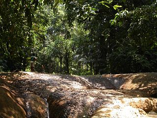
The flora consists of many unique varieties of tropical plants. Blessed with a tropical climate and roughly 17,000 islands, Indonesia is the nation with the second highest biodiversity in the world. The flora of Indonesia reflects an intermingling of Asian, Australian and unique, Indonesian lineages. This is due to the geography of Indonesia, located between the aforementioned continents. The archipelago consists of a variety of regions, from the tropical rain forests of the northern lowlands and the seasonal forests of the southern lowlands through the hill and mountain vegetation, to subalpine shrub vegetation. With the second longest coastline in the world, Indonesia also has many swamps and other varieties of coastal vegetation. Combined, these all give rise to a huge floral biodiversity. There are about 28,000 species of flowering plants documented in Indonesia, including 2500 orchids, 122 species of bamboo, over 350 species of rattan and 400 species of Dipterocarpus, including ebony, sandalwood and teakwood. Indonesia is also home to some unusual species of carnivorous plants. One exceptional species is known as Rafflesia arnoldi, named after Sir Thomas Stamford Raffles and Dr. Thomas Arnold, who discovered the flower in the depths of Bengkulu, southwest Sumatra. This parasitic plant has the largest flower of any plant, does not produce leaves and grows only on one species of liana on the rainforest floor. Another unusual plant is Amorphophallus titanum from Sumatra. Numerous species of insect trapping pitcher plants can also be found in Borneo, Sumatra, and other islands of the Indonesian archipelago. There are a staggering 6000 traditional medicinal plants used as Jamu.,
The climate of Indonesia is almost entirely tropical. The uniformly warm waters that make up 81% of Indonesia's area ensure that temperatures on land remain fairly constant, with the coastal plains averaging 28 °C (82 °F), the inland and mountain areas averaging 26 °C (79 °F), and the higher mountain regions, 23 °C (73 °F). Temperature varies little from season to season, and Indonesia experiences relatively little change in the length of daylight hours from one season to the next; the difference between the longest day and the shortest day of the year is only forty-eight minutes. This allows crops to be grown all year round.
Liga Indonesia Third Division is the fifth level football league in Indonesian football competition system. Currently, this competition, along with First Division and Second Division, is managed by the Amateur League Board of the Football Association of Indonesia (PSSI).

The association football tournament at the 2011 Southeast Asian Games took place from 3 to 21 November 2011. This edition of the tournament was only for the men's competition. No women's competition was held as the host nation Indonesia did not have enough stadiums to host two categories of football at the same time, but other reasons were put into consideration, such as the poor performance of the Indonesian women's national team. It was played among U-23 national teams. All matches took place in Jakarta. This was the first time that all Southeast Asian nations participated in the football tournament at a SEA Games.

North Minahasa Regency is a regency in North Sulawesi, Indonesia. Its capital is Airmadidi. It was originally part of the Minahasa Regency until it was split off and established as a separate regency on 20 November 2003. It covers an area of 1,059.24 km2, and had a population of 188,904 at the 2010 Census; this had risen to 224,993 at the 2020 Census, and the official estimate as at mid 2022 was 229,368. The Regency includes the offshore islands of Bangka and Talisei to the north of Sulawesi, and Mantenang and Naeng Besar to the northwest.

Gorontalo is a province of Indonesia on the island of Sulawesi. Located on the Minahasa Peninsula, Gorontalo was formerly part of the province of North Sulawesi until its inauguration as a separate province on 5 December 2000.
Gandang Dewata National Park is located at Mamasa Regency, West Sulawesi, Indonesia.
Nokilalaki Mountain is a mountain located in Palolo, Sigi Regency, Central Sulawesi, Indonesia. It has an elevation of 2,357 meters (7,733 ft).

Lubang Jeriji Saleh is a limestone cave complex in Indonesia in the Sangkulirang-Mangkalihat Karst located in the remote jungle of Bengalon district in East Kutai, East Kalimantan province on Borneo island. In a 2018 publication a team of researchers announced to have found the then-oldest known work of figurative art in the world among the cave paintings, at 40,000 years old. However, the same team has since found and dated an elaborate therianthrope rock art panel in the Leang Bulu’ Sipong 4 cave in Sulawesi's Maros-Pangkep karst to around 44,000 years old, older than the figurative art in Lubang Jeriji Saleh.

Modisi is a town in South Bolaang Mongondow Regency, North Sulawesi Province, Indonesia. Modisi is divided into hamlets, namely Hamlet One Modisi and Dusun Dua Modisi, and there are 4 RTs namely RT 01, RT 02, RT 03 and RT 04
