Mount Rearguard | |
---|---|
Highest point | |
Elevation | 12,209 ft (3,721 m) [1] |
Prominence | 1,044 ft (318 m) [1] |
Coordinates | 45°02′54″N109°31′35″W / 45.04833°N 109.52639°W Coordinates: 45°02′54″N109°31′35″W / 45.04833°N 109.52639°W [2] |
Geography | |
Location | Carbon County, Montana, U.S. |
Parent range | Beartooth Mountains |
Topo map | USGS Silver Run Peak |
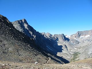
Mount Rearguard (12,209 feet (3,721 m)) is in the Beartooth Mountains in the U.S. state of Montana. [3] The peak is one of the tallest in the Beartooth Mountains and is in the Absaroka-Beartooth Wilderness in Custer National Forest. A small remnant glacier lies to the east of Mount Rearguard, which sits at the western edge of the Hellroaring Plateau.
The Beartooth Mountains are located in south central Montana and northwest Wyoming, U.S. and are part of the 944,000 acres (382,000 ha) Absaroka-Beartooth Wilderness, within Custer, Gallatin and Shoshone National Forests. The Beartooths are the location of Granite Peak, which at 12,807 feet (3,904 m) is the highest point in the state of Montana. The mountains are just northeast of Yellowstone National Park and are part of the Greater Yellowstone Ecosystem. The mountains are traversed by road via the Beartooth Highway with the highest elevation at Beartooth Pass 10,947 ft (3,337 m)). The name of the mountain range is attributed to a rugged peak found in the range, Beartooth Peak, that has the appearance of a bear's tooth.
Montana is a landlocked state in the Northwestern United States. Montana has several nicknames, although none are official, including "Big Sky Country" and "The Treasure State", and slogans that include "Land of the Shining Mountains" and more recently "The Last Best Place".
Absaroka-Beartooth Wilderness was created from existing National Forest lands in 1978 and is located in Montana and Wyoming, United States. The wilderness is partly in Gallatin, Custer and Shoshone National Forests and is composed of 944,000 acres (3,820 km2). The wilderness encompasses two distinct mountain ranges, namely the Beartooth and Absaroka ranges. These ranges are completely distinct geologically speaking with the Absarokas composed primarily of volcanic and metamorphic rock, while the Beartooths are made up almost entirely of granitic rocks. The Absarokas are noted for their dark and craggy appearance, lush and heavily forested valleys and abundant wildlife. The highest peak in the range, located in Wyoming, is Francs Peak at 13,153 feet (4,009 m). The Beartooths are more alpine with huge treeless plateaus and the highest peak in the state of Montana. The wilderness contains 30 peaks over 12,000 feet (3,700 m). The wilderness is an integral part of the 20-million-acre (81,000 km2) Greater Yellowstone Ecosystem and borders Yellowstone National Park.
Castle Mountain is in the Beartooth Mountains in the U.S. state of Montana, about 20 miles (32 km) ENE of Cooke City-Silver Gate. It is located in the Gallatin National Forest and Custer National Forest, just outside the northern boundary of Yellowstone National Park in the Absaroka-Beartooth Wilderness.
Whitetail Peak is in the Beartooth Mountains in the U.S. state of Montana. The peak is one of the tallest in the Beartooth Mountains, the fifth-tallest in Montana, and is located in the Absaroka-Beartooth Wilderness of Custer National Forest.
Silver Run Peak is in the Beartooth Mountains in the U.S. state of Montana. The peak is one of the tallest in the Beartooth Mountains, the six tallest in Montana, and is located in the Absaroka-Beartooth Wilderness of Custer National Forest. Silver Run Peak is the high point of the expansive Silver Run Plateau, a high-altitude plateau in the eastern Beartooth Mountains.
Tempest Mountain is in the Beartooth Mountains in the U.S. state of Montana. The peak is one of the tallest in the Beartooth Mountains, the eighth tallest in Montana and is in the Absaroka-Beartooth Wilderness of Custer National Forest. Tempest Mountain is less than 1 mi (1.6 km) ENE of Granite Peak, the tallest mountain in Montana.
Mount Peal is in the Beartooth Mountains in the U.S. state of Montana. The peak is one of the tallest in the Beatooth Mountains, the ninth tallest in Montana and is in the Absaroka-Beartooth Wilderness of Custer National Forest. The nearest taller mountain to Mount Peal is Tempest Mountain, 1 mi (1.6 km) WNW.
Bowback Mountain is in the Beartooth Mountains in the U.S. state of Montana. The peak is one of the tallest in the Beatooth Mountains, the 11th tallest in Montana and is in the Absaroka-Beartooth Wilderness in Custer National Forest.
Mount Villard is in the Beartooth Mountains in the U.S. state of Montana. The peak is one of the tallest in the Beartooth Mountains and is in the Absaroka-Beartooth Wilderness on the border of Custer and Gallatin National Forests. Hidden Glacier lies to the northwest of the peak.
Mount Hague is in the Beartooth Mountains in the U.S. state of Montana. The peak is one of the tallest in the Beartooth Mountains and is in the Absaroka-Beartooth Wilderness of Custer National Forest.
Spirit Mountain is in the Beartooth Mountains in the U.S. state of Montana. The peak is one of the tallest in the Beartooth Mountains and is in the Absaroka-Beartooth Wildernessin Custer National Forest.
Sundance Mountain is in the Beartooth Mountains in the U.S. state of Montana. The peak is one of the tallest in the Beartooth Mountains and is in the Absaroka-Beartooth Wildernessin Custer National Forest.
Cairn Mountain is in the Beartooth Mountains in the U.S. state of Montana. The peak is in the Absaroka-Beartooth Wilderness in Custer National Forest. Cairn Mountain is 1.24 mi (2.00 km) south of Granite Peak, the tallest mountain in Montana.
Pyramid Mountain is in the Beartooth Mountains in the U.S. state of Montana. The peak is in the Absaroka-Beartooth Wilderness in Custer National Forest.
Snowbank Mountain is in the Beartooth Mountains in the U.S. state of Montana. The peak is in the Absaroka-Beartooth Wilderness in Custer National Forest. The tiny Snowbank Glacier lies immediately southeast of the peak.
Mystic Mountain is in the Beartooth Mountains in the U.S. state of Montana. The peak is in the Absaroka-Beartooth Wilderness in Custer National Forest and approximately 1.5 mi (2.4 km) west of Granite Peak.
Sky Pilot Mountain is in the Beartooth Mountains in the U.S. state of Montana. The peak is in the Absaroka-Beartooth Wilderness on the borders of Custer and Gallatin National Forests. The Hopper Glacier lies on the east flank of the peak.
Metcalf Mountain is in the Beartooth Mountains in the U.S. state of Montana. The peak is in the Absaroka-Beartooth Wilderness in Custer National Forest and named for Lee Metcalf, former U.S. Senator from Montana.
Sylvan Peak is in the Beartooth Mountains in the U.S. state of Montana. The peak is in the Absaroka-Beartooth Wilderness in Custer National Forest.
Mount Inabnit is in the Beartooth Mountains in the U.S. state of Montana. The peak is in the Absaroka-Beartooth Wilderness in Custer National Forest.
Bears Tooth is a mountain spire in the Beartooth Mountains in the U.S. state of Montana. The peak is in the Absaroka-Beartooth Wilderness in Custer National Forest, and is adjacent to Beartooth Mountain. Bears Tooth is the namesake for numerous other points in the region and the Beartooth Mountains themselves. Known by the Native American Crow as "Na Piet Say", translated as bears tooth, the spire can be seen from the Beartooth Highway.
This Montana state location article is a stub. You can help Wikipedia by expanding it. |