The Mount Buffalo National Park is a national park in the alpine region of Victoria, Australia. The 31,000-hectare (77,000-acre) national park is located approximately 350 kilometres (220 mi) northeast of Melbourne in the Australian Alps. Within the national park is Mount Buffalo, a moderately high mountain plateau, with an elevation of 1,723 metres (5,653 ft) above sea level.

Mount Elbrus is the highest mountain in Russia and Europe. It is a dormant volcano rising 5,642 m (18,510 ft) above sea level, and is the highest stratovolcano in the supercontinent of Eurasia, as well as the tenth-most prominent peak in the world. It is situated in the southern Russian republic of Kabardino-Balkaria in the western extension of Ciscaucasia, and is the highest peak of the Caucasus Mountains.

The Wasatch Range or Wasatch Mountains is a mountain range in the western United States that runs about 160 miles (260 km) from the Utah-Idaho border south to central Utah. It is the western edge of the greater Rocky Mountains, and the eastern edge of the Great Basin region. The northern extension of the Wasatch Range, the Bear River Mountains, extends just into Idaho, constituting all of the Wasatch Range in that state.

Manipur is a state in northeast India, with the city of Imphal as its capital. It is bounded by the Indian states of Nagaland to the north, Mizoram to the south and Assam to the west. It also borders two regions of Myanmar, Sagaing Region to the east and Chin State to the south. The state covers an area of 22,327 km2 (8,621 sq mi). The official and most widely spoken language is the Meitei language. Native to the Meitei people, it is also used as a lingua franca by smaller communities, who speak a variety of other Tibeto-Burman languages. Manipur has been at the crossroads of Asian economic and cultural exchange for more than 2,500 years. This exchange connects the Indian subcontinent and Central Asia to Southeast Asia, East Asia, Siberia, regions in the Arctic, Micronesia and Polynesia enabling migration of people, cultures and religions.
The Cantabrian Mountains or Cantabrian Range are one of the main systems of mountain ranges in Spain. They stretch for over 300 km (180 miles) across northern Spain, from the western limit of the Pyrenees to the Galician Massif in Galicia, along the coast of the Cantabrian Sea. Their easternmost end meets the Sistema Ibérico.

Senapati, is one of the 16 districts of the Indian state of Manipur. The present Senapati district was formed in December 2016, after spawning off the Sadar Hills region in the south into a separate Kangpokpi district. The district headquarter is located in the municipality of Tahamzam.

Kohima District is a district of the Indian state of Nagaland. It is the home of the Angami Nagas. As of 2011, it is the most populous district of Nagaland, with a population of 267,988, 45% of which is urban. The district is home to 13.55% of Nagaland's entire population. The administrative headquarters of the district is located at Kohima, the capital city of Nagaland. Kohima District is also the seventh-largest district in Nagaland with an area of 1,207 square kilometres (466 sq mi).

Telescope Peak is the highest point within Death Valley National Park, in the U.S. state of California. It is also the highest point of the Panamint Range, and lies in Inyo County. From atop this desert mountain one can see for over one hundred miles in many directions, including west to Mount Whitney, and east to Charleston Peak. The mountain was named for the great distance visible from the summit.

Bhandardara is a holiday resort village near Igatpuri, in the western ghats of India. The village is located in the Akole tehsil, Ahmednagar district of the state of Maharashtra, about 185 kilometers (115 mi) from Mumbai, 155 kilometers (96 mi) from Ahmednagar and 73 kilometers (45 mi) from Nashik.
Mount Bazardüzü is a mountain peak in the Greater Caucasus range on the border between Russia (Dagestan) and Azerbaijan. At 4,466 metres (14,652 ft) above sea level, it is the highest peak in both Dagestan and Azerbaijan, and is located in the Qusar region. The southernmost point of Dagestan is located about seven kilometers southwest of the peak. Translated from Azerbaijani, Bazarduzu means “market square”, more precisely as a specific landmark - “turn to the market, bazaar”. In the Middle Ages in the Shahnabad Valley, located east of this peak, annual large multinational fairs were held.

Mount Washburn, elevation 10,219 feet (3,115 m), is a prominent mountain peak in the Washburn Range in Yellowstone National Park, Wyoming, United States. The peak was named in 1870 to honor Henry D. Washburn, leader of the Washburn–Langford–Doane Expedition. The Washburn Range is one of two mountains ranges completely within the boundaries of Yellowstone.

Arizona is a landlocked state situated in the southwestern region of the United States of America. It has a vast and diverse geography famous for its deep canyons, high- and low-elevation deserts, numerous natural rock formations, and volcanic mountain ranges. Arizona shares land borders with Utah to the north, the Mexican state of Sonora to the south, New Mexico to the east, and Nevada to the northwest, as well as water borders with California and the Mexican state of Baja California to the southwest along the Colorado River. Arizona is also one of the Four Corners states and is diagonally adjacent to Colorado.

Mount Banks, otherwise known as Mount King George, is a mountain within the Explorers Range of the Blue Mountains Range that is a spur off the Great Dividing Range, is located within the Blue Mountains National Park, approximately 100 kilometres (62 mi) west of Sydney in New South Wales, Australia. Mount Banks is located 8 kilometres (5.0 mi) from the nearest residential area,Mount Tomah, has an elevation of 1,049 metres (3,442 ft) AMSL, and can be accessed relatively easily via the Bells Line of Road.

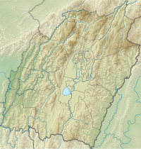
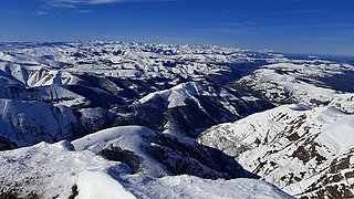
The Dzüko Valley, also known as Dzükou Valley or Dziiko Valley, is a valley located in between Senapati district of Manipur and Kohima district of Nagaland in Northeast India. This valley is well known for its natural environment, seasonal flowers and flora & fauna.

Northeast India consists of eight states: Arunachal Pradesh, Assam, Manipur, Meghalaya, Mizoram, Nagaland, Sikkim and Tripura. Tourism in this area is based around the unique Himalayan landscape and culture distinct from the rest of India.

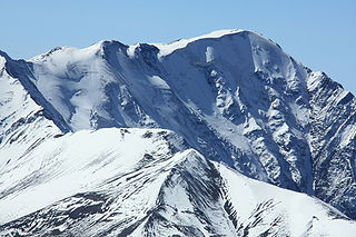
Viswema is a Southern Angami Naga village in the Kohima District of the Indian state of Nagaland. With a resident population of 7417, it is the second biggest village in the state and is part of the contiguous built-up of the Kohima Metropolitan Area that extends into the neighboring areas of Jakhama, Kigwema and Khuzama in the Southern Angami region, forming the second largest urban agglomerations in Nagaland. Its vast territory also lies across the inter-state boundary in Manipur where notable features including Mount Tempü (Iso) at 9822 feet (2994m) also the highest peak in Manipur, the thick forest of Kezol-tsa and a major portion of the Dzüko Valley is located.

Kigwema is a village in the southern region of Nagaland, India. It is located in Jakhama Circle of Kohima District. The village is located 15 km (9.3 mi) south of Kohima, the capital of Nagaland.
The Kezol-tsa Forest is a thick old-growth forest along the southern and northern edges of the Indian states of Nagaland and Manipur. The forest is located on the southern part of Dzüko Valley.
Southern Angami or Japfüphiki is a geo-cultural region located in the southern part of Kohima District in the state of Nagaland in India with a portion of its territory also lying across the inter-state border in the Senapati District of Manipur.

Imphal Valley or Manipur Valley is located in the Indian state of Manipur and is an irregular almost oval shaped canyon that was formed as a result of the multiple small rivers that originate from neighbouring hill regions surrounding the valley and flow through it. The water in the Imphal valley is fetched from several rivers that flows via the valley, such as Imphal River, Iril River, Thoubal River, Khuga River and Sekmai river.