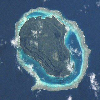
Motuloa or Motulua is a very small island on the north of Nukufetau in Tuvalu. It is an oval with a length of 200 m, and lies between Teafuanonu and Teafuaniua.
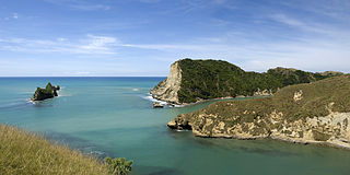
Pourewa Island lies in Tolaga Bay, just offshore from Cook's Cove in New Zealand.
The Kadavu Group is an archipelago south of Viti Levu, one of Fiji's two main islands. Dominated by Kadavu Island, the fourth largest island in Fiji, the group also includes Ono, Dravuni, Galoa and a number of islets in the Great Astrolabe Reef.

Naigani is an island in Fiji's Tailevu Province, 8 kilometres (5 mi) north-west of Ovalau. It is also about 10 kilometres (6 mi) from Tailevu Point on the main island of Viti Levu. It has a land area of 1.9 square kilometres (0.73 sq mi). The island's maximum height is 184 metres (604 ft).
Nananu-i-Ra is an island in Fiji about 3 kilometers off the north coast of the main island of Viti Levu, near the town of Rakiraki in Ra Province. The island is 3.5 square kilometers and has a maximum elevation of 180 meters. The name "Nananu-I-Ra" means "Daydream of the West" in Fijian. Fijian mythology holds that Nananu-I-Ra is the point of departure for disembodied spirits leaving this world for the afterlife.
Serua is one of Fiji's fourteen provinces. Its 830 square kilometers occupy the southernmost areas of Viti Levu, being one of 8 provinces based on Fiji's largest island. It had a population of 15,461 at the 2007 census.

Tailevu is one of the 14 provinces of Fiji. Its capital town is Nausori, which lies along the banks of the Rewa River.

Moturiki is an island belonging to Fiji's Lomaiviti Archipelago. Covering an area of 10.9 square kilometers, it is situated at 17.45° South and 178.44° East. To the north-east is the nearby island of Ovalau.
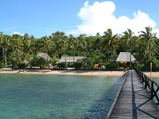
Tuvuca is a small island off Vanua Balavu in Fiji's Lau archipelago. It is a densely wooded and inhabited island and rises 800 feet above sea level at the highest point. There is only one village on the island, which has a population of around 180 people. There is a primary school. Tuvuca has untapped deposits of phosphate.
Yanuca Lailai is a 72-acre (0.29 km2), volcanic rock, limestone island located between the islands of Ovalau and Moturiki in Fiji. The coastline has mangrove trees, volcanic rock cliffs and beaches, and the interior abounds in jungle.
Matanukulaelae is an uninhabited islet of Nukufetau, Tuvalu. The estimate elevation above sea level is 5 meters.
Motufetau is a small uninhabited islet of Nukufetau, Tuvalu, which is on the east side of Nukufetau atoll.

Teafuanonu is an uninhabited islet on the north-east of Nukufetau atoll, Tuvalu.
Teafatule is an uninhabited islet of Nukufetau, Tuvalu.
Luasamotu is an uninhabited islet of Vaitupu, Tuvalu. Luasamotu on the reef off the eastern part of Vaitupu known as Matangi.
Motutanifa or Motu o tanifa is an uninhabited islet of Vaitupu, Tuvalu, which is located on the reef to the north of the part of Vaitupu known as Muli.
Motuoroi Island is a small island off the northeast of New Zealand's North Island. It is located close to the small settlement of Anaura, halfway between Tolaga Bay and Tokomaru Bay.
Fulton Adventist University College is a co-educational boarding tertiary institution situated on the western side of Viti Levu on the main island of Fiji. It is operated by the Seventh-day Adventist church and serves the island countries of Fiji, American Samoa, Cook Islands, Kiribati, French Polynesia, Nauru, New Caledonia, Niue, Samoa, Solomon Islands, Tonga, Tuvalu, and Vanuatu. Its services are also offered to Pacific Islanders and other interested individuals living in Australia, New Zealand, and overseas.
Lomaiviti Province is one of the 14 provinces of Fiji. Administratively, it forms part of Fiji's Eastern Division and of the Kubuna Confederacy, one of three traditional chiefly hierarchies in Fiji.
This page is based on this
Wikipedia article Text is available under the
CC BY-SA 4.0 license; additional terms may apply.
Images, videos and audio are available under their respective licenses.