
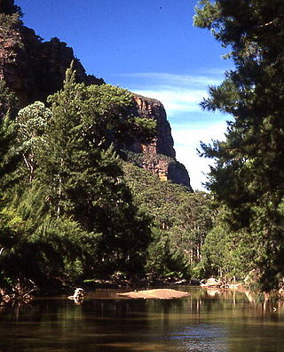
The Blue Mountains National Park is a protected national park that is located in the Blue Mountains region of New South Wales, in eastern Australia. The 267,954-hectare (662,130-acre) national park is situated approximately 80 kilometres (50 mi) west of Sydney, and the park boundary is quite irregular as it is broken up by roads, urban areas and inholdings. Despite the name mountains, the area is an uplifted plateau, dissected by a number of larger rivers. The highest point in the park is Mount Werong at 1,215 metres (3,986 ft) above sea level; while the low point is on the Nepean River at 20 metres (66 ft) above sea level as it leaves the park.

Gulaga National Park is a national park on the south coast of New South Wales, Australia, about 15 kilometres (9.3 mi) south of Narooma. The park is dominated by Gulaga, also known as Mount Gulaga. The former Wallaga Lake National Park, Goura Nature Reserve, and Mount Dromedary Flora Reserve were combined to form this park in 2001. The park features the southernmost subtropical rainforest in New South Wales.

Wollumbin National Park is a national park located in northern New South Wales, Australia, 642 kilometres (399 mi) north of Sydney near the border with the state of Queensland. It surrounds Mount Warning, part of a remnant caldera of a much larger extinct volcano. The park is administered by the NSW National Parks and Wildlife Service. The park is part of the Scenic Rim Important Bird Area, identified as such by BirdLife International because of its importance in the conservation of several species of threatened birds. In addition to numerous bird species, carpet python, land mullet, eastern small-eyed snake, lace monitor, black-bellied marsh snake and long-nosed potoroo can be found here.
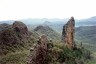
Warrumbungle National Park is a heritage listed national park located in the Orana region of New South Wales, Australia. The national park is located approximately 550 kilometres (340 mi) northwest of Sydney and contained within 23,311 hectares. The park attracts approximately 35,000 visitors per annum.
The Wollemi National Park is a protected national park and wilderness area that is located in the northern Blue Mountains and Lower Hunter regions of New South Wales, in eastern Australia. The 501,703-hectare (1,239,740-acre) park, the second largest national park in New South Wales, contains the 361,113-hectare (892,330-acre) Wollemi Wilderness – the largest such wilderness area in Australia – and is situated approximately 130 kilometres (81 mi) northwest of Sydney.

The Lamington National Park is a national park, lying on the Lamington Plateau of the McPherson Range on the Queensland/New South Wales border in Australia. From Southport on the Gold Coast the park is 85 kilometres (53 mi) to the southwest and Brisbane is 110 kilometres (68 mi) north. The 20,600 hectares Lamington National Park is known for its natural environment, rainforests, birdlife, ancient trees, waterfalls, walking tracks and mountain views. The park protects parts of the Eastern Australian temperate forests.

The Main Range is a mountain range and national park in Queensland, Australia, located predominantly in Tregony, Southern Downs Region, 85 kilometres (53 mi) southwest of Brisbane. It is part of the World Heritage Site Gondwana Rainforests of Australia. It protects the western part of a semicircle of mountains in South East Queensland known as the Scenic Rim. This includes the largest area of rainforest in South East Queensland. The park is part of the Scenic Rim Important Bird Area, identified as such by BirdLife International because of its importance in the conservation of several species of threatened birds.

Moogerah Peaks is a National Park in the Fassifern Valley of South East Queensland, Australia, located approximately 70 km south west of the state capital Brisbane. The 676-hectare park consists of four separate protected areas which surround volcanic peaks and rocky cliffs near Moogerah Dam.
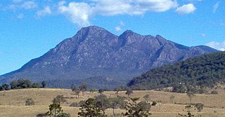
Mount Barney National Park is a national park in Queensland (Australia), 90 km southwest of Brisbane. It amalgamated the adjacent Mount Lindesay National Park in 1980. It is part of the Scenic Rim Important Bird Area, identified as such by BirdLife International because of its importance in the conservation of several species of threatened birds.
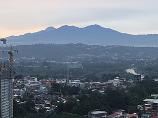
Mount Apo, also known locally as Apo Sandawa, is a large solfataric, dormant stratovolcano on the island of Mindanao, Philippines. With an elevation of 3,142.79 meters (10,311.0 ft) above sea level, it is the highest-mountain in the Philippine Archipelago, Mindanao and 24th-highest peak of an island on Earth. Located on the tripartite border of Davao City and Davao del Sur in the Davao Region, and Cotabato in Soccsksargen, Mount Apo is the most-prominent mountain in the Philippines. The peak overlooks from Davao City 45 kilometers (28 mi) to the northeast, Digos 25 kilometers (16 mi) to the southeast, and Kidapawan 20 kilometers (12 mi) to the west. It is a protected area and a Natural Park of the Philippines.

Kluane National Park and Reserve are two protected areas in the southwest corner of the territory of Yukon. The National Park Reserve was set aside in 1972 to become a national park, pending settlement of First Nations land claims. It covered an area of 22,013 square kilometres. When agreement was reached with the Champagne and Aishihik First Nations over an eastern portion of the Reserve, that part—about 5,900 square kilometres —became a national park in 1993, and is a unit of the national park system administered co-operatively with Parks Canada. The larger western section remains a Reserve, awaiting a final land claim settlement with the Kluane First Nation. The park borders British Columbia to the south, while the Reserve borders both British Columbia to the south, and the United States (Alaska) to the south and west.

Nelson Lakes National Park is in the South Island of New Zealand, at the northern end of the Southern Alps. It was formed after the passing of the National Parks Act in 1952. It was created in 1956. The park contains beech forests, multiple lakes, snow-covered mountains and valleys created by glaciers during the ice ages.

Viti Levu is the largest island in the Republic of Fiji. It is the site of the nation's capital, Suva, and home to a large majority of Fiji's population.
Rwenzori Mountains National Park is a Ugandan national park and UNESCO World Heritage Site located in the Rwenzori Mountains. Almost 1,000 km2 (386 sq mi) in size, the park has Africa's third highest mountain peak and many waterfalls, lakes, and glaciers. The park is known for its beautiful plant life.
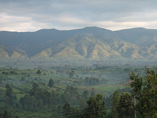
The Scenic Rim is a group of forested mountain ranges of the Great Dividing Range, located south of Brisbane agglomeration, straddling the border between south-eastern Queensland and north-eastern New South Wales, Australia. In 2021, the Scenic Rim was named as a Lonely Planet top destination for 2022.

Mount Tomanivi, previously named Mount Victoria and also known as Tomaniivi, is an extinct volcano located in the northern highlands of Viti Levu. At 1,324 metres (4,344 ft), Mount Tomanivi is the highest mountain in Fiji. A trail leads to the summit of Tomanivi from the village of Navai. The main river systems, the Rewa, Navua, Sigatoka, and Ba, all have their headwaters in the central mountain area.

The Three Parallel Rivers of Yunnan Protected Areas is a UNESCO World Heritage Site in Yunnan province, China. It lies within the drainage basins of the upper reaches of the Jinsha (Yangtze), Lancang (Mekong) and Nujiang (Salween) rivers, in the Yunnan section of the Hengduan Mountains.

Kitanglad Mountain Range is a mountain range that dominates the northern central portion of the province of Bukidnon. It occupies portions of eight of the municipalities and cities in the province such as Talakag, Baungon, Libona, Manolo Fortich, Impasugong, Lantapan and Malaybalay. The range is one of the few remaining rainforests in the Philippines, hosting one of the most important diverse species of rare and endemic wildlife such as the Philippine eagle. Five of its peaks have very high elevations: Mount Dulang-dulang, the highest at 2,941 m (9,649 ft); Mount Kitanglad at 2,899 meters; Mount Maagnaw at 2,742 meters; Mount Lumuluyaw at 2,612 meters; and Mount Tuminungan at 2,400 meters.

The Mounts Iglit–Baco National Park is a protected area of the Philippines and an ASEAN Heritage Park located in the island of Mindoro in central Philippines. The park covers an area of 75,445 hectares surrounding Mount Iglit and Mount Baco in the central interior of Mindoro. It was established in 1970 by virtue of Republic Act No. 6148. In 2003, the Association of Southeast Asian Nations listed it as one of its four heritage parks in the Philippines. The park has also been nominated in the Tentative List of UNESCO World Heritage Sites.

The Fiji tropical dry forests are a tropical dry forest ecoregion in Fiji. The dry forests occupy the leeward northwestern portion of Fiji's two largest islands, Viti Levu and Vanua Levu.

