The Alpine National Park is a national park located in the Central Highlands and Alpine regions of Victoria, Australia. The 646,000-hectare (1,600,000-acre) national park is located northeast of Melbourne. It is the largest National Park in Victoria, and covers much of the higher areas of the Great Dividing Range in Victoria, including Victoria's highest point, Mount Bogong at 1,986 metres (6,516 ft) and the associated subalpine woodland and grassland of the Bogong High Plains. The park's north-eastern boundary is along the border with New South Wales, where it abuts the Kosciuszko National Park. On 7 November 2008 the Alpine National Park was added to the Australian National Heritage List as one of eleven areas constituting the Australian Alps National Parks and Reserves.

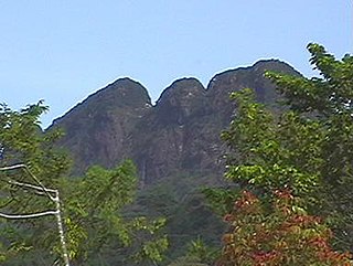
The Main Range is a mountain range and national park in Queensland, Australia, located predominantly in Tregony, Southern Downs Region, 85 kilometres (53 mi) southwest of Brisbane. It is part of the World Heritage Site Gondwana Rainforests of Australia. It protects the western part of a semicircle of mountains in South East Queensland known as the Scenic Rim. This includes the largest area of rainforest in South East Queensland. The park is part of the Scenic Rim Important Bird Area, identified as such by BirdLife International because of its importance in the conservation of several species of threatened birds.

The Caucasus Mountains is a mountain range at the intersection of Asia and Europe. Stretching between the Black Sea and the Caspian Sea, they are surrounded by the Caucasus region and are home to Mount Elbrus, the highest peak in Europe at 5,642 metres (18,510 ft) above sea level.

The Australian Alps are a mountain range in southeast Australia. The range comprises an interim Australian bioregion, and is the highest mountain range in Australia. The range straddles the borders of eastern Victoria, southeastern New South Wales, and the Australian Capital Territory. It contains Australia's only peaks exceeding 2,000 m (6,600 ft) in elevation, and is the only bioregion on the Australian mainland in which deep snow falls annually. The range comprises an area of 1,232,981 ha.

Viti Levu is the largest island in Fiji. It is the site of the country's capital and largest city, Suva, and home to a large majority of Fiji's population.
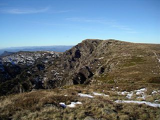
The Victorian Alps, also known locally as the High Country, is a large mountain system in the southeastern Australian state of Victoria. Occupying the majority of eastern Victoria, it is the southwestern half of the Australian Alps, the tallest portion of the Great Dividing Range. The Yarra and Dandenong Ranges, both sources of rivers and drinking waters for Melbourne, are branches of the Victorian Alps.

The North Shore Mountains are a mountain range overlooking Vancouver in British Columbia, Canada. Their southernmost peaks are visible from most areas in Vancouver and form a distinctive backdrop for the city.

Mount Elgon National Park is a national park in Kenya and Uganda that lies 140 kilometres (87 mi) northeast of Lake Victoria. The park covers an area of 1,279 square kilometres (494 sq mi). The Ugandan part of the park covers 1,110 km2 (430 sq mi) while the Kenyan part covers 169 km2 (65 sq mi). The Kenyan part of the park was gazetted in 1968, the Ugandan part in 1992.

The Wellington Range is a mountain range located in the southeast region of Tasmania, Australia. The range is mainly composed of dolerite and features evidence of past glaciation.
Victoria Peak within the Maya Mountains is the second highest mountain in Belize, at a height of 1,120 metres (3,675 ft). The highest peak in the country, Doyle's Delight, at a height of 1,124 metres (3,688 ft), is located 57 kilometres (35 mi) southwest of Victoria Peak. Victoria Peak is situated in the Stann Creek District of Belize, in the Cockscomb Basin Wildlife Sanctuary, and is home to many flora and fauna common to Belize. It was pronounced a natural monument in 1998, comprising about 4,847 acres bordered by the Sittee River Wildlife Reserve, Cockscomb Basin Wildlife Sanctuary, and Chiquibul National Park.

The wildlife of Cameroon is composed of its flora and fauna. Bordering Nigeria, it is considered one of the wettest parts of Africa and records Africa's second highest concentration of biodiversity. To preserve its wildlife, Cameroon has more than 20 protected reserves comprising national parks, zoos, forest reserves and sanctuaries. The protected areas were first created in the northern region under the colonial administration in 1932; the first two reserves established were Mozogo Gokoro Reserve and the Bénoué Reserve, which was followed by the Waza Reserve on 24 March 1934. The coverage of reserves was initially about 4 percent of the country's area, rising to 12 percent; the administration proposes to cover 30 percent of the land area.

The New Guinea Highlands, also known as the Central Range or Central Cordillera, is a long chain of mountain ranges on the island of New Guinea, including the island's highest peak, Puncak Jaya, Indonesia, 16,024 ft (4,884 m), the highest mountain in Oceania. The range is home to many intermountain river valleys, many of which support thriving agricultural communities. The highlands run generally east-west the length of the island, which is divided politically between Indonesia in the west and Papua New Guinea in the east. These mountains stretch from the Weyland Mountains starting in Wondama Bay Regency in the west to the Milne Bay Province in the east.
Mount Victoria is a mountain in the Mount Victoria Forest Reserve in north-east Tasmania, Australia, and also forms part of the Ben Lomond bioregion and the Ben Lomond National Park. The peak has an elevation of 1,213 metres (3,980 ft) above sea level and is the 58th highest mountain in Tasmania. It is a prominent feature of the reserve, and is a popular venue with bushwalkers.

The Huachuca Mountains are part of the Sierra Vista Ranger District of the Coronado National Forest in Cochise County in southeastern Arizona, approximately 70 miles (110 km) south-southeast of Tucson and southwest of the city of Sierra Vista. Included in this area is the highest peak in the Huachucas, Miller Peak, and the region of the Huachucas known as Canelo Hills in eastern Santa Cruz County. The mountains range in elevation from 3,934 feet (1,199 m) at the base to 9,466 feet (2,885 m) at the top of Miller Peak. The second highest peak in this range is Carr Peak, elevation 9,200 feet (2,804 m). The Huachuca Mountain area is managed principally by the United States Forest Service (41%) and the U.S. Army (20%), with much of the rest being private land (32%). Sierra Vista is the main population center.
Mount Moco, at 2,620 metres (8,600 ft), is the highest mountain in Angola. It is located in Huambo Province in the western part of the country, 70 kilometres (43 mi) west of the city of Huambo. Mount Moco was named one of Angola's "seven wonders" in 2014. The mountain is a destination for birdwatchers, hikers, and people participating in rappelling and paragliding.

Mount Gosford is a mountain located in southern Quebec, Canada, at the border with Maine. It lies entirely in Saint-Augustin-de-Woburn in Estrie and is part of the White Mountains of the Appalachians. It is named after Archibald Acheson, 2nd Earl of Gosford, governor general of British North America from 1835 to 1835. It is the 21st highest peak in Quebec and 4th in Southern Quebec.

Mount Oku, or Kilum Mountain, is the largest volcano in the Oku Massif, in the Cameroon Volcanic Line, located in the Oku region of the Western High Plateau of Cameroon. It is the second highest mountain in mainland Central Africa. The stratovolcano rises to 3,011 metres (9,879 ft) above sea level, and is cut by a large caldera.

Many areas of Vietnam are under protection. While the national reserves cover small areas of scientific significance with restricted access, the national parks also cover wetlands of Ramsar designated areas and BirdLife International inscribed bird areas. The largest of the national parks initially covered were the Cúc Phương National Park, the Cát Tiên National Park, and the Côn Đảo National Park which to start with were forest areas cum reserves or prohibited areas. The objective for creating national parks was to allow access to the reserved areas as a part of ecotourism and cultural needs with full attention to the basic approach of conservation of natural environmental resources.

The Nimba Range forms part of the southern extent of the Guinea Highlands, adjacent to the Toura Mountains. The highest peak is Mount Nimba on the border of Liberia, Ivory Coast and Guinea, at 1,752 m (5,748 ft), and at the intersection of the Nimba and Toura Mountains. "Mount Nimba" may refer either to Mount Richard-Molard or to the entire range. Other peaks include Grand Rochers at 1,694 m (5,558 ft), Mont Sempéré at 1,682 m (5,518 ft), Mont Piérré Richaud at 1,670 m (5,480 ft), Mont Tô at 1,675 m (5,495 ft), and Mont LeClerc 1,577 m (5,174 ft), all of them are located in Guinea. Mount Nimba Strict Nature Reserve of Guinea and Ivory Coast covers significant portions of the Nimba Range.
The wildlife of Lebanon refers to the flora and fauna of Lebanon, a country in Asia located at the eastern end of the Mediterranean Sea. The country has four main geographical areas: the coastal plain, Mount Lebanon, the Beqaa Valley and the Anti-Lebanon Mountains. The climate is Mediterranean, with the coastal regions experiencing hot, humid summers and cool, wet winters, and the elevated areas inland experiencing colder winters with snow that lingers on into the summer. The country offers a variety of habitats for wildlife, including mountains, valleys, marshes, coastal plains, salt marshes and sea coasts.

