
Niassa is a province of Mozambique. It has an area of 129,056 km2 and a population of 1,810,794 (2017). It is the most sparsely populated province in the country. Lichinga is the capital of the province. There are a minimum estimated 450,000 Yao people living in Mozambique. They largely occupy the eastern and northern part of the Niassa province and form about 40% of the population of Lichinga, the capital of this province.

The Eastern Highlands, also known as the Manica Highlands, is a mountain range on the border of Zimbabwe and Mozambique. The Eastern Highlands extend north and south for about 300 kilometres (190 mi) through Zimbabwe's Manicaland Province and Mozambique's Manica Province.
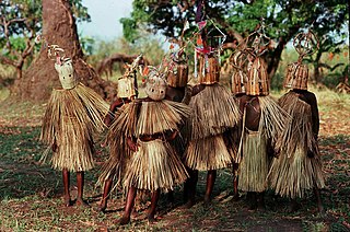
The Yao people are a major Bantu ethnic and linguistic group living at the southern end of Lake Malawi. They played an important role in the history of Southeast Africa, notably in the 19th century. The Yao are a predominantly Muslim-faith group of about two million, whose homelands encompass the countries of Malawi, the north of Mozambique, and the Ruvuma and Mtwara Regions of Tanzania. The Yao have a strong cultural identity, transcending national borders.
Articles related to Mozambique include:
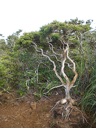
Dwarf forest, elfin forest, or pygmy forest is an uncommon ecosystem featuring miniature trees, inhabited by small species of fauna such as rodents and lizards. They are usually located at high elevations, under conditions of sufficient air humidity but poor soil. There are two main dwarf forest ecosystem types, involving different species and environmental characteristics: coastal temperate and montane tropical regions. Temperate coastal dwarf forest is common for parts of Southern California. Montane tropical forests are found across tropical highlands of Central America, northern South America and Southeast Asia. There are also other isolated examples of dwarf forests scattered across the world, while the largest dwarf forest is found in the Philippines.

The wildlife of Mozambique consists of the flora and fauna of this country in southeastern Africa. Mozambique has a range of different habitat types and an ecologically rich and diverse wildlife. This includes 236 species of mammal, 740 species of bird and 5,692 species of vascular plant. The Maputaland-Pondoland-Albany hotspot, with significantly high levels of biodiversity, stretches from the southern tip of Mozambique into northeastern South Africa.
The long-billed forest warbler, also known as the long-billed tailorbird, is a songbird of the family Cisticolidae, formerly part of the "Old World warbler" assemblage. It is found in Tanzania and Mozambique. Its natural habitat is subtropical or tropical moist montane forests. It is threatened by habitat destruction.

Niassa Reserve is a nature reserve in Cabo Delgado Province and Niassa Province, Mozambique. Covering over 42,000 square kilometres, it is the largest protected area in the country. The reserve is part of the Trans-Frontier Conservation Area and links to the Tanzanian Lukwika-Lumesule Game Reserve. It will connect to the Lake Niassa Reserve when it is completed.

Mecula District is a district of Niassa Province in north-western Mozambique. The principal town is Mecula.

Mount Namuli is the second highest mountain in Mozambique and the highest in the Province of Zambezia. It is 2,420 m (7,940 ft) high and was measured, surveyed and described in 1886 by Henry Edward O'Neill, the British consul in Mozambique. The Namuli massif consists of a level plateau with the granite dome of Mount Namuli above. The area was historically clad in tropical rainforest and is an important biodiversity hotspot with many endemic species of animals and plants. The lower slopes are now mainly used for the cultivation of tea and the middle slopes for other agricultural purposes, with indigenous forest now mostly restricted to the higher parts and corridors along water courses.

Mount Mabu is a mountain in northern Mozambique, famous for its old-growth rain forest. Mount Mabu is approximately 1,700 metres high and the forest covers about 7,000 hectares. While well known locally, the Mount Mabu forest and its extremely diverse wildlife were unknown to plant and animal scientists until 2005.

The Southern Zanzibar–Inhambane coastal forest mosaic, also known as the Southern Swahili coastal forests and woodlands, is a tropical moist broadleaf forest ecoregion of eastern Africa. It is a southern variation of Northern Zanzibar-Inhambane coastal forest mosaic. The ecoregion supports habitats of forest, savanna and swamps. The southern portion of the ecoregion is not as well studied due to the 1977-1992 civil war in Mozambique.

The Lugenda or Lujenda is a river of northern Mozambique. It flows in a south-north direction from Lake Amaramba/Lake Chiuta and is the largest tributary of the Ruvuma River. It joins the Luambala River at 13°26′12″S36°18′20″E. The river valley is reported to be only 800 feet (240 m) above sea level. North of Lake Chiuta, those on the west bank call it the Msambiti River. At one point, the Lugenda splits into several streams with islands between them, some of whom are populated such as the island Achemponda.
Negomano or Ngomano is a village in northern Mozambique, in Cabo Delgado Province. It is located on the border with Tanzania on the confluence of the Ruvuma River and the Lugenda River.

Mount Gorongosa is an inselberg in Sofala Province of central Mozambique. Its highest peak, Gogogo, reaches an elevation of 1,863 meters. It was created by Karoo Volcanism.
Mount Chiperone is a mountain in northern Mozambique. It lies in Milange District of Zambézia Province, 40 km SSW of the town of Milange.

Mount Lico is an inselberg mountain in the Alto Molocue District of Zambezia Province in northern Mozambique, most notable for its old-growth rainforest and its lack of penetration by humans. Mount Lico is approximately 1,100 metres above sea level but is distinctive in having sheer rock walls of up to 700 metres above the surrounding countryside that have all but prevented human intrusion. The forest on top, within a volcanic crater, covers only about 30 hectares.
Mount Inago, also known as Serra Inago, is a mountain in northern Mozambique.
The Njesi Highlands are a range of mountains in northern Mozambique.
Mount Mecula is a mountain in northern Mozambique. It is located in Niassa Province, near the center of Niassa National Reserve.
