Related Research Articles

The River Severn, at 220 miles (354 km) long, is the longest river in Great Britain. It is also the river with the most voluminous flow of water by far in all of England and Wales, with an average flow rate of 107 m3/s (3,800 cu ft/s) at Apperley, Gloucestershire. It rises in the Cambrian Mountains in mid Wales, at an altitude of 2,001 feet (610 m), on the Plynlimon massif, which lies close to the Ceredigion/Powys border near Llanidloes. The river then flows through Shropshire, Worcestershire and Gloucestershire. The county towns of Shrewsbury, Worcester and Gloucester lie on its course.

Shropshire is a ceremonial county in the West Midlands of England, on the border with Wales. It is bordered by Cheshire to the north-east, Staffordshire to the east, Worcestershire to the south-east, Herefordshire to the south, and the Welsh principal areas of Powys and Wrexham to the west and north-west respectively. The largest settlement is Telford, while Shrewsbury is the county town.

Montgomeryshire was one of the thirteen historic counties of Wales. It was named after its county town, Montgomery, which in turn was named after one of William the Conqueror's main counsellors, Roger de Montgomerie, who was the 1st Earl of Shrewsbury.

The Quarry is the main recreational park in Shrewsbury, the county town of Shropshire, England. The park was created in 1719 and encompasses 29 acres. It is listed Grade II in Historic England's Register of Parks and Gardens. With a location within easy walking distance of Shrewsbury town centre, Shrewsbury Sixth Form College and Shrewsbury School, it is the most heavily used public park within the county.

The name Rea Brook can refer to either of two brooks in Shropshire, England.

Cressage is a village and civil parish in Shropshire, England. It is located 4 miles (6.4 km) north-west of the nearest town Much Wenlock and 8 miles (12.9 km) south-east of Shrewsbury. It lies the junction of the A458 and B4380 roads; the River Severn flows around its northern boundary. The parish council is combined with the neighbouring parish of Sheinton. The village's population at the 2021 United Kingdom census was 730.
Frankwell is a district of the town of Shrewsbury, in Shropshire, England. It lies adjacent to the River Severn, to the northwest of the town centre, and is one of Shrewsbury's oldest suburbs. The main road running through the area is also called Frankwell.

St George's Bridge was a bridge over the River Severn in Shrewsbury, England; so named as it was close to the medieval St George's Hospital. It connected Frankwell, an old suburb of the town, to the town centre via Mardol. The gate on the town side was called Mardol Gate and is located where the Mardol Quay Gardens are. The gate on the other side was called Welsh Gate or St George's Gate. The bridge, sometimes now known as the Old Welsh Bridge, was demolished in 1795 and was replaced with the Welsh Bridge.

The Welsh Bridge is a masonry arch viaduct in the town of Shrewsbury, England, which crosses the River Severn. It connects Frankwell with the town centre. It is a Grade II* listed building.
The town of Shrewsbury in Shropshire, England, has a history that extends back at least as far as the year 901, but it could have been first settled earlier. During the early Middle Ages, the town was a centre of the wool trade, and this was a peak in its importance. During the Industrial Revolution, comparatively little development took place in the town, although it did serve as a significant railway town after the development of rail transport in the area. The town today retains much of its historic architecture.
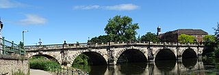
The English Bridge is a masonry arch viaduct, crossing the River Severn in Shrewsbury, Shropshire. The present bridge is a 1926 rebuilding and widening of John Gwynn's design, completed in 1774. A bridge is known to have stood at this spot since at least Norman times. Historically, it was known as the "Stone Bridge". It is a Grade II* listed building.

The Severn Way is a waymarked long-distance footpath in the United Kingdom, which follows the course of the River Severn through Mid Wales and western England.
Coleham is a district of the town of Shrewsbury in Shropshire, England. It is located just south, over the River Severn, from Shrewsbury town centre.
Sutton Farm is a suburb on the south-east side of Shrewsbury, in the civil parish of Shrewsbury, in Shropshire, England.

Shrewsbury is a market town and civil parish in Shropshire, England. It is sited on the River Severn, 33 miles (53 km) northwest of Wolverhampton, 15 miles (24 km) west of Telford, 31 miles (50 km) southeast of Wrexham and 53 miles (85 km) north of Hereford. At the 2021 census, the parish had a population of 76,782. It is the county town of the ceremonial county of Shropshire.

The Quantum Leap is a sculpture situated next to the River Severn in Shrewsbury, Shropshire, England. It was created to celebrate the bicentenary of the birth of evolutionist Charles Darwin, who was born in the town in 1809. The sculpture was unveiled on 8 October 2009 by Randal Keynes, a great-great-grandson of Darwin.

Mardol is an historic street in Shrewsbury, Shropshire with a variety of architectural styles, ranging from Tudor timber-framed buildings to more modern constructs. It runs from the site of the St George's Bridge up to the town centre, a place called Mardol Head.
The Shrewsbury North West Relief Road is a planned 4 miles (6.4 km) long single-carriageway bypass for Shrewsbury in England. It has been approved but requires additional funding in order to be built.
The town of Shrewsbury in Shropshire, England has historically been affected by flooding of the River Severn. The Frankwell area, has been particularly affected, but flood defence measures have largely been effective in the area.

The King's Head is an old public house on the historic street Mardol in Shrewsbury, Shropshire, England. It was previously known as the "Last Inn" as it was the last inn in Shrewsbury on the route out of town towards Wales. It is a Grade II* listed building.
References
- ↑ Williams-Karesch, Jrschina (2003). Shrewsbury: A Biography. Shrewsbury: MPR.
- ↑ Reynolds, Jordan (9 August 2018). "Concerns raised over fresh plans for The Stew in Shrewsbury". The Shropshire Star. Retrieved 25 October 2018.
- ↑ "Darwin's Childhood Garden". shrewsburylocalhistory.org. Archived from the original on 9 May 2021. Retrieved 9 May 2021.
- ↑ "Wildlife campaigners buy Charles Darwin's garden". Shropshire Star. 25 January 2014. Retrieved 25 October 2018.
- ↑ "Activists fight to save 550-year-old oak threatened by new Shrewsbury road". The Guardian. 26 April 2021. Retrieved 9 May 2021.