
Sørfold is a municipality in Nordland county, Norway. It is part of the traditional district of Salten. The administrative centre of the municipality is the village of Straumen. Other villages in the municipality include Leirfjordgården, Mørsvikbotn, Røsvika, Rørstad, Styrkesvik, and Øvre Kvarv. The municipality surrounds the Sørfolda fjord and stretches east to the border with Sweden.

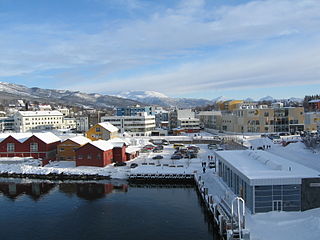
Bardufoss is a town and commercial centre in Målselv Municipality in Troms county, Norway. The three villages of Andselv, Andslimoen, and Heggelia together form the Bardufoss area. Bardufoss is located in the Målselvdalen valley near the confluence of the Barduelva and Målselva rivers. It is located about 82 kilometres (51 mi) north of the town of Narvik and about 70 kilometres (43 mi) south of the city of Tromsø. Bardufoss Airport is located here. The 2.96-square-kilometre (730-acre) urban area has a population (2017) of 2,545 which gives it a population density of 860 inhabitants per square kilometre (2,200/sq mi).

is the largest village and administrative centre of Porsanger Municipality in Finnmark county, Norway. The village lies at the southern end of the large Porsangerfjorden. The 2.3-square-kilometre (570-acre) village has a population (2017) of 2,283 which gives the village a population density of 993 inhabitants per square kilometre (2,570/sq mi).
Finnsnes is a small town that is the administrative centre of Senja Municipality in Troms county, Norway. The town is located on the mainland part of Norway, just across the Gisundet strait from the island of Senja. The Gisund Bridge connects Finnsnes to the suburban villages of Silsand and Laukhella on the island of Senja. The municipality is well-provided with kindergartens and a decentralized school system on both primary and secondary levels. There are also three schools on the upper secondary/high school level and a center for decentralized studies at the university level. Finnsnes Church is located in the center of the town.

is a town in Nordland county, Norway. The town is also the administrative centre of the municipality of Vestvågøy. Leknes was designated a "town" in 2002. The 2.52-square-kilometre (620-acre) town has a population (2018) of 3,556 which gives the town a population density of 1,411 inhabitants per square kilometre (3,650/sq mi).

Skibotn is a village in Storfjord Municipality in Troms county, Norway. It is located on the southeastern shore of the Lyngen fjord in Northern Norway. The village area is located at the crossroads of the European route E6 and European route E8 highways. The distance by road to Kilpisjärvi, the northernmost community in the western "arm" of Finland, is approximately 50 kilometres (31 mi). Skibotn Chapel is located in the village.

Kvaløysletta is an urban neighborhood within the city of Tromsø which is part of Tromsø Municipality in Troms county, Norway. The neighborhood is located on the eastern shore of the island of Kvaløya, about 5 kilometres (3.1 mi) northwest of the city centre of Tromsø. The residential area is located just across the Sandnessund Bridge from the island of Tromsøya where the city centre is located. The 3.12-square-kilometre (770-acre) neighborhood has a population (2017) of 8,681 which gives the village a population density of 2,782 inhabitants per square kilometre (7,210/sq mi).

Nordkjosbotn (Norwegian) or Gárgán (Northern Sami) is a small village in Balsfjord Municipality in Troms county, Norway. The village lies about 70 kilometres (43 mi) southeast of the city of Tromsø. Two major highways, European route E6 and European route E8, meet in this village, making it a major crossroads in Northern Norway, with an estimated annual passage of 3 million people. The 0.7-square-kilometre (170-acre) village has a population (2017) of 464 which gives the village a population density of 663 inhabitants per square kilometre (1,720/sq mi). Nordkjosbotn Church is located in this village. Macks Ølbryggeri, a brewery, has been operating in Nordkjosbotn since 2012.

Bangsund is a village in the municipality of Namsos in Trøndelag county, Norway. It lies along the Løgnin arm of the Namsenfjorden, about 15 kilometres (9.3 mi) south of the town of Namsos. The villages of Klinga and Sævik lie to the northeast along the Norwegian County Road 17.
Husøy is a village in Senja Municipality in Troms county, Norway. The village covers the entire island of Husøy which is located in the Øyfjorden off the northwest coast of the large island of Senja. The village/island is located about 53 kilometres (33 mi) southwest of the city of Tromsø. The village of Fjordgård sits about 4 kilometres (2.5 mi) across the fjord on the island of Senja.

Furuflaten (Norwegian) or Vuošvággi (Northern Sami) is a village in Lyngen Municipality in Troms county, Norway. The village is located along the Lyngen fjord. Furuflaten is located at the mouth of the Lyngsdalselva river, about 15 kilometres (9.3 mi) south of the village of Lyngseidet and about 54 kilometres (34 mi) straight southeast of the city of Tromsø.
Sørkjosen is a village in Nordreisa Municipality in Troms county, Norway. The village is located along the shores of the Reisafjorden about 5 kilometres (3.1 mi) northwest of the municipal center of Storslett. Sørkjosen has many industries including fishing, dairy production, and a sawmill.

Sommarøy is an old fishing village in the western part of Tromsø Municipality in Troms county, Norway. It is located about 36 kilometres (22 mi) west of the city of Tromsø and is a popular tourist destination due to its white sand beaches and scenery. The 0.34-square-kilometre (84-acre) village has a population (2017) of 321 which gives the village a population density of 991 inhabitants per square kilometre (2,570/sq mi).

Ersfjordbotn is a village in Tromsø Municipality in Troms county, Norway. The village is located on an isthmus between the Ersfjorden and the Kaldfjorden on the island of Kvaløya. It is about 15 kilometres (9.3 mi) west of the city of Tromsø. The villages of Kjosen and Kvaløysletta are located just to the east of Ersfjordbotn.
Bleik is a fishing village in Andøy Municipality in Nordland county, Norway. The village is located on the northwestern part of the island of Andøya, about 10 kilometres (6.2 mi) southwest of the village of Andenes.

Hillesøy is a former municipality in the old Troms county in Norway. The municipality existed from 1855 until its dissolution in 1964. It was located on both sides of the Malangen fjord in what is now the present-day municipalities of Tromsø and Senja. The administrative centre was located at Brensholmen on the western shore of the island of Kvaløya. Brensholmen is also the location of Hillesøy Church, the main church for the municipality.

Bogen (Norwegian) or Ránda (Northern Sami) is the administrative centre of Evenes Municipality in Nordland county, Norway. The village is located along the shore of the Ofotfjorden, about 10 kilometres (6.2 mi) northeast of the village of Liland. The European route E10 highway passes through the village. Bogen Chapel is located in this village.

Tromsøysund is a former municipality in Troms county in Norway. The 1,596-square-kilometre (616 sq mi) municipality existed from 1838 until its dissolution in 1964. The municipality encompassed most of what is now Tromsø Municipality including areas on the island of Kvaløya and on the mainland. It completely surrounded the city of Tromsø, both on a number of islands as well as on the mainland. The municipality included the villages of Bjerkaker, Tromsdalen, and Movik. The administrative centre was the village of Tromsdalen, just across the strait from the city of Tromsø.

Kjosen is a village in Tromsø Municipality in Troms og Finnmark county, Norway. The village lies on the island of Kvaløya, about 13 kilometres (8.1 mi) west of the city of Tromsø. It is located at the end of the Kaldfjorden, immediately north of the village of Kaldfjord. The village of Ersfjordbotn lies about 5 kilometres (3.1 mi) to the west and the village of Kvaløysletta lies about 3 kilometres (1.9 mi) to the east.

Kroken is a neighborhood in the city of Tromsø which lies in Tromsø Municipality in Troms og Finnmark county, Norway. The neighborhood is located along the Tromsøysundet strait on the mainland, just across the strait from the city centre of Tromsø which lies on the island of Tromsøya. The Tromsdalen area of the city of Tromsø lies about 4 kilometres (2.5 mi) to the south and the village of Movik lies about 3 kilometres (1.9 mi) to the north. The village is considered part of the Tromsdalen urban area.


