Moz, Vayots Dzor

Last updated

Moz in the province of Vayots Dzor was an ancient town in southern Armenia that was destroyed by an earthquake and volcanic eruption in the year of 735. It is the oldest historically documented settlement in Vayots Dzor. In the 7th to 8th centuries, the town was a significant trading and craft center on the Silk Road, with several thousand inhabitants. Moz was the main seat of the Armenian princes of Syunik from the House of Orbelian, who relocated it to Yeghegis after the destruction of the town.

Contents

Moz is located on a 1,200 meter high hill above the right bank of the Arpa River, three to four kilometers southeast of the village of Malishka. In its heyday, the town was surrounded by fertile lands and dense forests. After the forests disappeared, the area began to be devastated. The place itself has disappeared. However, the ruins, that occupy an area of about 8 hectares, [1] still lie on an important transport route, the M2 highway, the only transit route for cargo from Iran to Yerevan and on to Georgia.

History

The oldest traces of settlement in Moz are dated to the Bronze Age. They include a large burial ground that extends across scattered hills about two to three kilometers east of Moz, as well as individual graves within Moz itself. People were buried in pairs. In addition to human ashes, archaeologists found dog skeletons, burnt branches, clay and ceramic vessels, obsidian, decorated bronze needles, and other objects. Based on their decoration, they are dated to the early 1st millennium BCE and associated with the Treghk-Vanadzor culture. Discoveries from a later period indicate that the site played an important role in the Urartian Empire. Hellenistic artifacts demonstrate the continued significance of the site after the fall of the empire.

In the 7th to 8th centuries, Moz was an important trade and craft center on the Silk Road. At that time the city had several thousand inhabitants. [1] [2] An earthquake and a volcanic eruption destroyed the city under the control of the Armenian Orbelian princes in 735. They moved their headquarters from Moz to Yeghegis after the destruction. The medieval historian Stepanos Orbelian describes the fall of Moz as divine punishment for the death of catholicos Stepanos Siunetsi, who is said to have been killed by a prostitute in Moz. According to him, an impenetrable darkness enveloped Moz's borders immediately after the murder. The earth then shook for forty days, burying tens of thousands of people. What remained was a desert, which is why the place was given the name Vayots Dzor (= Valley of the woe), which is still in use today. However, dates recorded on khachkars (cross stones) and tombstones (1266, 1284, 1311, 1321, 1471, 1483) as well as tribute payments to the Tatev monastery in the 13th century prove that the place was not immediately abandoned, even though it had lost its importance. [3] Later, the small village of Novlar (also known as Moz) was located on the village desert. In Stepanos Orbelya’s list of villages belonging to Tatev its tax size was 12. [4] [1] The successor settlement was abandoned at the beginning of the 20th century. .

The first excavations of Moz town took place in 1930 by archaeological expedition of Academy of Science of ASSR. [1] The next and bigger excavations were undertaken between 1978 and 1979 under the direction of Hasmik Israyelyan. The Bronze Age and Medieval artifacts found during this excursion and subsequent excavations are on display at the Yeghegnadzor Regional Museum.

Earthquake and volcanic eruption

Historians and chronicler Movses Kaghankatvatsi, Stepanos Orbelyan, and Kirakos Gandzaketsi describe Moz town and the earthquake that shoke the land for forty days. The first survived report on the event is given by Kaghankatvatsi (10th century). According to him the earthquake was accompanied by “an impenetrable sarkness” over Mocu town, it shoke the lande for forty days and nearly 10000 people were “swallowed up”. The name of the region – Vayots Dzor (=Valley of the woe), Movses connects to this devastating earthquake.

Stepanos Orbelian (13th century) [5] gives more detailed description. Completing Kaghankatvatsi he reports about the collapse of mountains, the complete crumbling of rocks. Common houses and fine palaces alike were turned to tombs for their residents. Springs and rivers dried up. Sounds similar to human voices were heard from the depths. The number of victims as 10000 he reported as registered taxpayers and added that nobody knew how many unregistered people perished in the earthquake. [2]

Kirakos Gandzaketsi (13th century) gives an abbreviated account of Orbelian's narrative. [6]

In their work of “A new catalogue of earthquakes in the historical Armenian area from antiquity to the 12th century” geologists Guidoboni, Emanuela; Traina, and Giusto (1995), carefully analyzing all the historical and geographical sources available, came to a conclusion that in 735 AD indeed there was a devastating earthquake in historical Moz (or Mozu) town. [7]

Even though none of the sources gives any information about the volcanic eruption caused by the Moz earthquake, nowadays it is widely believed that Vayotssar mountain, which is located in Vayots Dzor province, north-west from the village Herher, is the result of that “eruption”. [8] Cuneiform expert and cartographer Eduard Melikyan insists on the assertion and shows the traces of lava on a map. He explains the existence of hot spring (such as Jermuk, Jermajur, Tsghuk) near the area by that eruption. Another justification he gives is the duration of the earthquake – 40 days. According to Melikyan only volcanic ones have such durations.

According to geologists, even if the youngest volcano in the territory of Republic of Armenia is Vayotssar mountain, its last eruption was 40000 years ago. [9]

Origin of the name "Vayots Dzor"

As we have seen above three historians explain the origin of “Vayots Dzor” by the devastating earthquake. This means that it should be mentioned in literature since 8th century. However, Movses Khorenatsi, who lived 841 years before Orbelian and 242 years before the horrible event, already used the name of Vayots Dzor. Egishe Vardapet, who also lived long before the earthquake, used the name of the province as it is now.

Related Research Articles

<span class="mw-page-title-main">Vayots Dzor Province</span> Province of Armenia

Vayots Dzor is a province (marz) of Armenia. It lies at the southeastern end of the country, bordering the Nakhchivan exclave of Azerbaijan to the west and the Kalbajar District of Azerbaijan to the east. It covers an area of 2,308 km2 (891 sq mi). With a population of only 52,324, it is the most sparsely populated province in the country. The capital and largest city of the province is the town of Yeghegnadzor.

<span class="mw-page-title-main">Yeghegnadzor</span> Capital and largest city of Vayots Dzor, Armenia

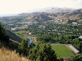
Yeghegnadzor is a town and urban municipal community in southern Armenia, serving as the provincial capital of Vayots Dzor Province and the Yeghegnadzor Municipality. It is located at a road distance of 123 km (76 mi) south of the capital Yerevan, on the shores of Srkghonk River, at a height of 1,194 meters (3,917 ft) above sea level.

<span class="mw-page-title-main">Jermuk</span> Town in Vayots Dzor, Armenia

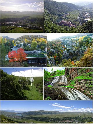
Jermuk is a mountain spa town and the centre of the Jermuk Municipality of the Vayots Dzor Province in southern Armenia, at a road distance of 53 km (33 mi) east of the provincial capital Yeghegnadzor. It was considered one of the popular destinations for medical tourism in the Soviet Union.

<span class="mw-page-title-main">Noravank</span> Monastery

Noravank is a 13th-century Armenian monastery, located 122 km from Yerevan in a narrow gorge made by the Amaghu River, near the town of Yeghegnadzor in Armenia. The gorge is known for its tall, sheer, brick-red cliffs, directly across from the monastery. The monastery is best known for its two-storey Surb Astvatsatsin Church, which grants access to the second floor by way of a narrow stone-made staircase jutting out from the face of building.

Momik was an Armenian architect, sculptor and a master artist of Armenian illuminated manuscripts. As a sculptor, Momik is also known for his fine carving of khachkars, found primarily at the monastery complex at Noravank. He held an eminent position at the Gladzor School of Illuminated Manuscripts in Syunik, established at Vayots Dzor under the patronage of the Orbelian family's historian, Stepanos Orbelian. Of the manuscripts authored by Momik, only several survive: one is found at the repository of the Mekhitarist Order in Vienna and three others are found at the Mashtots Institute of Ancient Manuscripts in Yerevan, Armenia.

<span class="mw-page-title-main">Orbelian dynasty</span> Armenian-Georgian noble family

The Orbelian lords of the province of Syunik were a noble family of Armenia, with a long history of political influence documented in inscriptions throughout the provinces of Vayots Dzor and Syunik, and recorded by the family historian Bishop Stepanos in his 1297 History of Syunik.

Movses Kaghankatvatsi, or Movses Daskhurantsi, is the reputed author of a tenth-century Classical Armenian historical work on Caucasian Albania and the eastern provinces of Armenia, known as The History of the Country of Albania.

<span class="mw-page-title-main">Vayk</span> Town in Vayots Dzor, Armenia

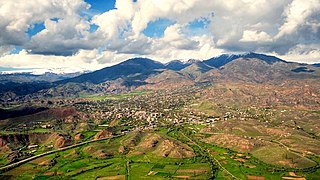
Vayk is a town and the centre of the Vayk Municipality of the Vayots Dzor Province of Armenia.

<span class="mw-page-title-main">Tatev Monastery</span> 9th-century Armenian Apostolic Christian monastery

The Tatev Monastery is a 9th-century Armenian Apostolic Christian monastery located on a large basalt plateau near the village of Tatev in the Syunik Province in southeastern Armenia. The term "Tatev" usually refers to the monastery. The monastic ensemble stands on the edge of a deep gorge of the Vorotan River. Tatev is known as the bishopric seat of Syunik and played a significant role in the history of the region as a center of economic, political, spiritual and cultural activity.

<span class="mw-page-title-main">Malishka</span> Place in Vayots Dzor, Armenia

Malishka is a village and rural municipal community of the Yeghegnadzor Municipality of the Vayots Dzor Province of Armenia.

<span class="mw-page-title-main">Azatek</span> Place in Vayots Dzor, Armenia

Azatek is a village in the Vayk Municipality of the Vayots Dzor Province of Armenia, on the left bank of the Arpa River.

<span class="mw-page-title-main">Hors, Armenia</span> Place in Vayots Dzor, Armenia

Hors is a village in the Yeghegis Municipality of the Vayots Dzor Province in Armenia. It is located 24 km northwest of the Province center, on the bank of the right-hand Hors tributary of Selimaget, 6–7 km northwest of the confluence of the Selimaget and Yeghegis rivers.

<span class="mw-page-title-main">Yeghegis</span> Place in Vayots Dzor, Armenia

Yeghegis is a village in the Yeghegis Municipality of the Vayots Dzor Province in Armenia. It has a rich historical past, with the medieval Zorats Church, the Tsakhats Kar Monastery and the Smbataberd fortress being located in the vicinity of Yeghegis, as well as a Jewish cemetery from the 13th century.

Esayi Abu-Musa was an Armenian prince of southern Artsakh who ruled over a significant part of Arran in the mid-9th century and is considered the founder of the Principality of Dizak.

<span class="mw-page-title-main">Areni Church</span>

Surb Astvatsatsin of Areni is a single-nave two-aisled domed church completed in the year 1321. It is located atop a plateau overlooking the Arpa River and the village of Areni in the Vayots Dzor Province of Armenia.

<span class="mw-page-title-main">Smbataberd</span> Medieval fortress in Vayots Dzor Province, Armenia

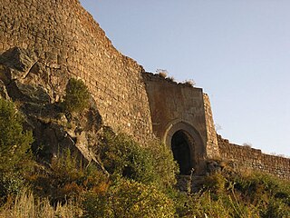
Smbataberd is a medieval fortress located upon the crest of a hill between the villages of Artabuynk and Yeghegis in the Vayots Dzor Province of Armenia. It may have existed as early as the 5th century or earlier, although other sources date it to the 9th to 11th centuries. Its large basalt walls have been well preserved, but much less remains of the structures inside the fortress. It served as the main fortress of the Armenian princes of Syunik when Yeghegis was the seat of the rulers of that province. It was further expanded in the 13th century under the Orbelian dynasty. It is now a notable tourist site in Vayots Dzor.

<span class="mw-page-title-main">Syunik (historical province)</span>

Syunik was a region of historical Armenia and the ninth province of the Kingdom of Armenia from 189 BC until 428 AD. From the 7th to 9th centuries, it fell under Arab control. In 821, it formed two Armenian principalities: Kingdom of Syunik and principality of Khachen, which around the year 1000 was proclaimed the Kingdom of Artsakh, becoming one of the last medieval eastern Armenian kingdoms and principalities to maintain its autonomy following the Turkic invasions of the 11th to 14th centuries.

<span class="mw-page-title-main">Diocese of Vayots Dzor</span>

Diocese of Vayots Dzor, is one of the newest dioceses of the Armenian Apostolic Church covering the Vayots Dzor Province of Armenia. The diocesan headquarters are located in the town of Yeghegnadzor. The seat of the bishop is the 12th-century Holy Mother of God Cathedral of Yeghegnadzor.

The 735 Vayots Dzor Province earthquake affected the Vayots Dzor Province.

The 906 K'argop' earthquake took place in the monastery K'argop', Armenia, c. 906. The monastery was also known as Xotakerk', the monastery of the Vegetarians. The earthquake occurred approximately 150 years following the 735 Vayots Dzor Province earthquake, and affected the same region.

References

  1. 1 2 3 4 Melkonyan, Husik (1982). Մոզ Ավանի Հուշակոթողները[The Monuments of Moz town] (in Armenian). Yerevan. p. 94.{{cite book}}: CS1 maint: location missing publisher (link)
  2. 1 2 Orbelian, Stepanos (1861) [13th century]. Պատմութիւն Տանն Սիսակայ[History of the State of Sisakan] (in Armenian). Moscow. pp. 103–104.{{cite book}}: CS1 maint: location missing publisher (link)
  3. Barkhudaryan, S. G. (1967). Դիվան հայ վիմագրության հատոր 3-րդ[Codex of Armenian inscriptions, volume 3] (in Armenian). Yerevan: ASSR, Academy of Science. pp. 23–26.
  4. Orbelian, Stepanos (1861) [13th century]. History of the State of Sisakan (in Armenian). Moscow. p. 373.{{cite book}}: CS1 maint: location missing publisher (link)
  5. Hacikyan, Agop J. (2002). The Heritage of Armenian Literature: From the sixth to the eighteenth century. Detroit: Wayne State University Press. ISBN   0-8143-3023-1.
  6. Gandzketsi, Kirakos (1909) [13th century]. Պատմութիւն Հայոց արարեալ Կիրաոսի վարդապետի Գանձակեցւոյ[The History of Armenia Created by Kirakos Gandzketsi] (in Armenian). Tbilisi. pp. 68–70.{{cite book}}: CS1 maint: location missing publisher (link)
  7. Guidoboni, Emanuela; Traina, and Giusto (1995). "A new catalogue of earthquackes in the historical Armenian area from antiquity to the 12th century". Annals of Geophysics. 1: 119–120.{{cite journal}}: CS1 maint: multiple names: authors list (link)
  8. Malkhasyan, Eduard (1970). Հայաստանը հանգած հրաբուխների երկիր[Armenia- the land of extinct volcanoes] (in Armenian). Yerevan: ASSR, Gitelik company. p. 21.
  9. Malkhasyan, Eduard (1970). Հայաստանը հանգած հրաբուխների երկիր[Armenia - the land of extinct volcanoes] (in Armenian). Yerevan: ASSR, Gitelik publishing house. p. 16.