Ruangwa is one of six districts of the Lindi Region of Tanzania. It is bordered to the north by the Kilwa District, to the south by the Mtwara Region and to the west by the Nachingwea District.

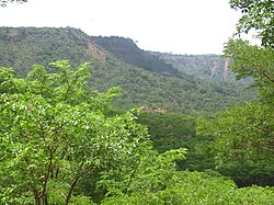
Newala is one of the five districts of the Mtwara Region of Tanzania. It is bordered to the west by the Masasi District, to the east by the Tandahimba District, to the south by Newala Town, and to the north by the Tandahimba and Masasi Districts. The district is home the Miyuyu Forest Reserve.
Makanda is an administrative ward in the Bahi District of the Dodoma Region of Tanzania. In 2016 the Tanzania National Bureau of Statistics report there were 8,582 people in the ward, from 7,896 in 2012.
Msanga is an administrative ward in the Chamwino District of the Dodoma Region of Tanzania. In 2016 the Tanzania National Bureau of Statistics report there were 10,502 people in the ward, from 9,663 in 2012.
Aghondi is an administrative ward in the Manyoni District of the Singida Region of Tanzania. In 2016 the Tanzania National Bureau of Statistics report there were 6,000 people in the ward, from 5,468 in 2012.

Nanyumbu is one of the six districts of the southern Mtwara Region in Tanzania.
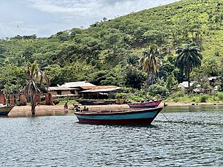
Kigoma District is one of the eight administrative districts of Kigoma Region in Tanzania. The district lies north of the city of Kigoma-Ujiji. Uvinza District, to the west and south of Ujiji, was split off from the Kigoma District in 1 July, 2013.

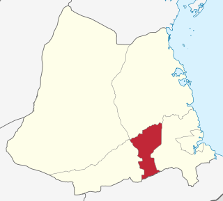
Mtwara Mikindani Municipal District Council is one of eight regional councils of the Mtwara Region in Tanzania. It is bordered to the north by the Lindi Region, to the east by the Indian Ocean and to the south and west by the Mtwara District. In 2016, the municipality has a total population of 113,732.

Gungu is an administrative ward in Kigoma-Ujiji District of Kigoma Region in Tanzania. The ward covers an area of 10.2 km2 (3.9 sq mi), and has an average elevation of 818 m (2,684 ft). In 2016 the Tanzania National Bureau of Statistics report there were 27,764 people in the ward, from 25,224 in 2012.

Kasingirima is an administrative ward in Kigoma-Ujiji District of Kigoma Region in Tanzania. The ward covers an area of 0.2 km2 (0.077 sq mi), and has an average elevation of 799 m (2,621 ft). In 2016 the Tanzania National Bureau of Statistics report there were 3,156 people in the ward, from 2,867 in 2012.

Kibirizi is an administrative ward in Kigoma-Ujiji District of Kigoma Region in Tanzania. The ward covers an area of 12.5 km2 (4.8 sq mi), and has an average elevation of 826 m (2,710 ft). In 2016 the Tanzania National Bureau of Statistics report there were 27,675 people in the ward, from 25,143 in 2012.
Kigoma is an administrative ward in Kigoma-Ujiji District of Kigoma Region in Tanzania. The ward covers an area of 4 km2 (1.5 sq mi), and has an average elevation of 789 m (2,589 ft). In 2016 the Tanzania National Bureau of Statistics report there were 7,604 people in the ward, from 6,908 in 2012.

Kitongoni is an administrative ward in Kigoma-Ujiji District of Kigoma Region in Tanzania. The ward covers an area of 1.2 km2 (0.46 sq mi), and has an average elevation of 773 m (2,536 ft). In 2016 the Tanzania National Bureau of Statistics report there were 7,675 people in the ward, from 6,973 in 2012.

Rusimbi is an administrative ward in Kigoma-Ujiji District of Kigoma Region in Tanzania. The ward covers an area of 0.7 km2 (0.27 sq mi), and has an average elevation of 783 m (2,569 ft). In 2016 the Tanzania National Bureau of Statistics report there were 7,462 people in the ward, from 6,779 in 2012.
Businde is an administrative ward in Kigoma-Ujiji District of Kigoma Region in Tanzania. The ward covers an area of 7.8 km2 (3.0 sq mi), and has an average elevation of 808 m (2,651 ft). In 2016 the Tanzania National Bureau of Statistics report there were 2,681 people in the ward, from 2,436 in 2012.
Buzebazeba is an administrative ward in Kigoma-Ujiji District of Kigoma Region in Tanzania. The ward covers an area of 7.8 km2 (3.0 sq mi), and has an average elevation of 792 m (2,598 ft). In 2016 the Tanzania National Bureau of Statistics report there were 20,304 people in the ward, from 18,446 in 2012.
Kasimbu is an administrative ward in Kigoma-Ujiji District of Kigoma Region in Tanzania. The ward covers an area of 1.9 km2 (0.73 sq mi), and has an average elevation of 783 m (2,569 ft). In 2016 the Tanzania National Bureau of Statistics report there were 5,405 people in the ward, from 4,910 in 2012.
Katubuka is an administrative ward in Kigoma-Ujiji District of Kigoma Region in Tanzania. The ward covers an area of 3 km2 (1.2 sq mi), and has an average elevation of 814 m (2,671 ft). In 2016 the Tanzania National Bureau of Statistics report there were 27,287 people in the ward, from 24,790 in 2012.
Kipampa is an administrative ward in Kigoma-Ujiji District of Kigoma Region in Tanzania. The ward covers an area of 1.8 km2 (0.69 sq mi), and has an average elevation of 777 m (2,549 ft). In 2016 the Tanzania National Bureau of Statistics report there were 8,714 people in the ward, from 7,917 in 2012.
Machinjioni is an administrative ward in Kigoma-Ujiji District of Kigoma Region in Tanzania. The ward covers an area of 1.1 km2 (0.42 sq mi), and has an average elevation of 839 m (2,753 ft). In 2016 the Tanzania National Bureau of Statistics report there were 3,814 people in the ward, from 3,465 in 2012.