
Sumatra is one of the Sunda Islands of western Indonesia. It is the largest island that is fully within Indonesian territory, as well as the sixth-largest island in the world at 475,807.63 km2 (182,812 mi.2), including adjacent islands such as the Simeulue, Nias, Mentawai, Enggano, Riau Islands, Bangka Belitung and Krakatoa archipelago.

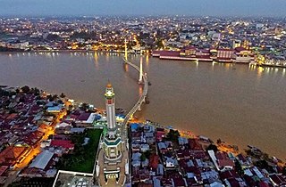
Palembang is the capital city of the Indonesian province of South Sumatra. The city proper covers 352.51 square kilometres on both banks of the Musi River in the eastern lowlands of southern Sumatra. It had a population of 1,668,848 at the 2020 Census; the official estimate as at mid 2022 was 1,729,546. Palembang is the second most populous city in Sumatra, after Medan, and the twelfth most populous city in Indonesia.

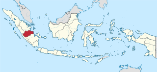
South Sumatra is a province of Indonesia, located on the southeast of the island of Sumatra. The capital and largest city of the province is the city of Palembang. The province borders the provinces of Jambi to the north, Bengkulu to the west and Lampung to the south, as well a maritime border with the Bangka Belitung Islands to the east. It is the largest province in the island of Sumatra, and it is slightly larger than Hungary. The Bangka Strait in the east separates South Sumatra and the island of Bangka, which is part of the Bangka Belitung Islands province. The province has an area of 91,592.43 km2 (35,364 sq mi) and has a population of 8,467,432 at the 2020 Census; the official estimate as at mid-2022 was 8,657,008. The province is rich in natural resources, such as petroleum, natural gas and coal. The province is inhabited by many different ethnic groups, with Palembangese being largest ethnic group. Most speak the Palembang language, which is mutually intelligible to both Indonesian and local Palembang Malay. Other ethnic groups include the Javanese, Sundanese, Minangkabau and Chinese. Most are concentrated in urban areas and are largely immigrants from other parts of Indonesia.
Jambi is a province of Indonesia. It is located on the east coast of central Sumatra and spans to the Barisan Mountains in the west. Its capital and largest city is Jambi. It is bordered by the provinces of Riau to the north, West Sumatra to the west, Bengkulu to the southwest, South Sumatra to the south, and sharing a maritime border with the Riau Islands to the east and the Pacific Ocean to the east. The province has a land area of 49,026.58 km2, and a sea area of 3,274.95 km2. It had a population of 3,092,265 according to the 2010 census and 3,548,228 according to the 2020 census. The official estimate as at mid 2022 was 3,631,136.

Bengkulu is a province of Indonesia. It is located on the southwest coast of Sumatra. It was formed on 18 November 1968 by separating out the area of the historic Bencoolen Residency from the province of South Sumatra under Law No. 9 of 1967 and was finalized by Government Regulation No. 20 of 1968. Spread over 20,130.21 km2, it is bordered by the provinces of West Sumatra to the north, Jambi to the northeast, Lampung to the southeast, and South Sumatra to the east, and by the Indian Ocean to the northwest, south, southwest, and west.

Bandar Lampung is the capital and largest city of the Indonesian province of Lampung. Located on the southern tip of Sumatra, Bandar Lampung was originally called Tanjungkarang–Telukbetung, since it was a unification of two major settlements in Lampung, before being renamed in 1983.

The Orang Batin Sembilan, Orang Rimba or Anak Dalam are mobile, animist peoples who live throughout the lowland forests of southeast Sumatra. Kubu is a Malay exonym ascribed to them. In the Malay language, the word Kubu can mean defensive fortification, entrenchment, or a place of refuge. It is metaphor for how the majority and dominant Islamic Melayu villagers believe them to use the interior forests as a means for resisting inclusion in the larger Malay social and Islamic religious world. As is the case with other forest peoples in the region, the term Kubu is associated with very negative connotations.
Jambi is the capital and largest city of the Indonesian province of Jambi. Located on the island of Sumatra, the city is a busy port on the Batang Hari River and an oil- and rubber-producing centre. The city is located 26 km (16 mi) from the ruins of Muaro Jambi Temple Compounds, an important city in the ancient Srivijaya kingdom.

Batang Hari is a regency of Jambi Province in Sumatra, Indonesia. It originally covered a wider area, but on 4 October 1999 this was split between a new Muaro Jambi Regency in the east and a reduced Batang Hari Regency in the west, which now covers an area of 5,804.83 km2. It had a population of 241,334 at the 2010 census and 301,700 at the 2020 census; the official estimate as at mid 2022 was 313,209. The administrative capital is the town of Muara Bulian.

Bungo Regency is a regency (kabupaten) of Jambi Province in Sumatra, Indonesia. It was created on 4 October 1999 by the division of the former Bungo Tebo Regency into a new Tebo Regency and this Bungo Regency. The regency covers an area of 4,659 km2. As at the 2010 census, the regency had a population of 303,135 and 362,363 at the 2020 census; the official estimate as at mid 2022 was 373,344. The administrative capital is the town of Muara Bungo.

East Tanjung Jabung Regency is a regency of Jambi Province, Indonesia. It is located on the island of Sumatra. The regency was created on 4 October 1999 by the division of the then Tanjung Jabung Regency into eastern and western halves. It now has an area of 5,085.71 km2 and had a population of 205,272 at the 2010 census and 229,813 at the 2020 census; the official estimate as at mid 2022 was 234,164. The capital lies at Muara Sabak.

Tebo Regency is a regency of Jambi Province, Indonesia. It is located on the island of Sumatra, and was created on 4 October 1999 by the division of the former Bungo Tebo Regency into a new Bungo Regency and this Tebo Regency. The regency has an area of 6,461 km² and had a population of 297,735 at the 2010 Census and 337,669 at the 2020 Census; the official estimate as at mid 2022 was 344,816. The regency seat is at the town of Muara Tebo.

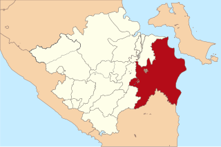
Banyuasin is a regency of South Sumatra Province in Indonesia. The Regency was formed on 10 April 2002 from the coastal and eastern areas formerly part of the Musi Banyuasin Regency. It takes its name from the main river which drains that area, the Banyuasin River. Pangkalan Balai is the regency seat. The regency borders Musi Banyuasin Regency, Jambi province and Bangka Strait to the north, Bangka Strait to the east, Ogan Komering Ilir Regency, Muara Enim Regency, and the city of Palembang to the south, and Musi Banyuasin Regency to the west. It has an area of 11,832.99 km2 and had a population of 749,107 at the 2010 census and 836,914 at the 2020 census; the official estimate as at mid 2022 was 839,401. Much of the regency is coastal lowland.

Muara Enim Regency is a regency of South Sumatra Province, Indonesia. The regency seat is the town of Muara Enim. The city of Prabumulih is an administrative body separating the main part of Muara Enim to the south of the city from a smaller part to its north. The regency until late 2012 covered an area of 8,587.94 km² and had a population of 717,717 at the 2010 Census; however, on 14 December 2012 five districts from the Muara Enim Regency were split off to form the new Penukal Abab Lematang Ilir Regency.

Musi Rawas Regency is a regency of South Sumatra Province, Indonesia. Prior to 2013, it covered an area of 12,134.57 km2 and had a population of 524,919 at the 2010 Census; however on 10 June 2013 the northern half of the regency was split off to form a separate North Musi Rawas Regency. Previous to 2001, the Regency had also included the city of Lubuklinggau, which was split off to form an independent city outside the regency.
Ogan Komering Ilir Regency is a regency of South Sumatra Province, Indonesia. It takes its name from the Ogan River and the Komering River, which are the two main rivers that drain the area. The name Ilir means downstream. The administrative centre is the town of Kayu Agung. The regency borders Palembang, Ogan Ilir Regency and Banyuasin Regency to the north, Bangka Strait, and Java Sea to the east, Lampung Province to the south, and Ogan Ilir Regency, and East Ogan Komering Ulu Regency to the west.

Muara Bungo Airport is an airport in Muara Bungo, Jambi, Indonesia. The airport started operating on November 25, 2012.

}} Colonel Maludin Simbolon was an Indonesian military officer, independence fighter, and Minister of Foreign Affairs in the Revolutionary Government of the Republic of Indonesia's (PRRI) Cabinet.
