
Humla District, a part of Karnali Province, is one of the seventy-seven districts of Nepal. The district, with Simikot as its district headquarters, covers an area of 5,655 km2 (2,183 sq mi) and has population of 50,858 as per the census of 2011. Humla is the 2nd largest district of Nepal. The Southern part and middle of Humla District is inhabited by Khas people, originating from Sinja valley, whereas the North border is mostly inhabited by Tibetans. Northern part of this district is administered by China since border skirmishes with India in 2020.

Hepka is a village and ward council of Namkha rural municipality in Humla District in the Karnali Province of north-western Nepal. At the time of the 1991 Nepal census it had a population of 977 persons living in 159 individual households.
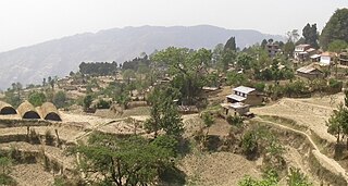
Limi is a village in the eponymously named Limi Valley and a ward council of Namkha rural municipality in Humla District in the Karnali Province of north-western Nepal. Previously the whole valley was known as the Limi Village Development Committee (VDC). As of the 1991 Nepal census, it had a population of 988 persons living in 169 individual households. The population of the village decreased to 904 individual according to 2011 Nepal census

Patarasi is a rural municipality located in Jumla District of Karnali Province of Nepal.
Limgha is a rural municipality ward no 4 and (सत्यवती) village council ward no 4 in Gulmi District in the Lumbini Zone of central Nepal. At the time of the 1991 Nepal census it had a population of 3285 persons living in 665 individual households.

Chulachuli is a rural municipality (gaunpalika) out of six rural municipality located in Ilam District of Province No. 1 of Nepal. There are a total of 10 municipalities in Ilam in which 4 are urban and 6 are rural.

Dhikurpokhari is a suburb and former Village Development Committee in Kaski District in the Gandaki Province of northern-central Nepal. At the time of the 1991 Nepal census it had a population of 7,392 persons living in 1,427 individual households.
Bhalche is a village development committee in Nuwakot District in the Bagmati Zone of central Nepal. At the time of the 1991 Nepal census it had a population of 2947 living in 624 individual households.
Bungtang is a village development committee in Nuwakot District in the Bagmati Zone of central Nepal. At the time of the 2011 Nepal census it had a population of 3288 living in 743 individual households.
Kakani is a Gaunpalika and former village development committee in Nuwakot District in Bagmati Province of central Nepal. At the time of the 1991 Nepal census, the Kakani village development committee administered a population of 7816 living in 1343 individual households.

Babare is a village in Kalinchowk Rural Municipality in Dolakha District in the Bagmati Province of north-eastern Nepal. At the time of the 1991 Nepal census it had a population of 3,392 people living in 739 individual households.
Gaurishankar is currently referred to as Ward No. 9 under Gaurishankar Rural Municipality in Bagmati Province, Dolakha District of Nepal. At the time of the 1991 Nepal census it had a population of 1,392 people living in 291 individual households. There are divided to 3 villages which are Tasi Nam, Simi Gau and Beding.
Malu, Nepal is a 3rd ward of Tamakoshi Rural Municipalities in Dolakha District in the 3 no. Province of north-eastern Nepal. At the time of the 1991 Nepal census it had a population of 2,439 people living in 497 individual households.

Melung is a Rural municipality located within the Dolakha District of the Bagmati Province of Nepal. The municipality spans 86.54 square kilometres (33.41 sq mi) of area, with a total population of 20,210 according to a 2011 Nepal census.
Mirge is a village development committee in Dolakha District in the Janakpur Zone of north-eastern Nepal. At the time of the 1991 Nepal census it had a population of 3,216 people living in 693 individual households. Now it is ward no 3 of Baiteshwar rural municipality.
Dimipokhari is a 2 no. Ward of Sunapati Rural Municipality in Ramechhap District which falls under 3 no. province of Nepal.It is located at north-eastern Nepal. At the time of the 1991 Nepal census it had a population of 2,997 people living in 626 individual households.
Khandadevi is a populated place and a ward of Khandadevi Rural Municipality. It was a village development committee before 10 March 2017. At the time of the 1991 Nepal census it had a population of 3,751 people living in 650 individual households.
Sangrampur is a Village Development Committee in Sarlahi District in the Janakpur Zone of south-eastern Nepal. Now, It is a part of Parsa Rural Municipality. It is the 2nd ward of this Rural Municipality. At the time of the 1991 Nepal census it had a population of 4,491 people residing in 769 individual households.
Jubing was a village development committee in Solukhumbu District in the Sagarmatha Zone of north-eastern Nepal. It was divided and merged into two new formed Rural municipality in 2017 when the old administrative structures were reconstructed. Ward no. 2, 3, 4 and 6 were incorporated with Dudhkoshi rural municipality and remaining all wards 1, 5, 7, 8 and 9 were incorporated with Khumbu Pasanglhamu rural municipality.

Namkha is the largest rural municipality of Nepal located in Humla District of Karnali Province.


