
Pretoria is South Africa's administrative capital, serving as the seat of the executive branch of government, and as the host to all foreign embassies to South Africa.

The Loop is Chicago's central business district and one of the city's 77 municipally recognized community areas. Located at the center of downtown Chicago on the shores of Lake Michigan, it is the second-largest business district in North America after Midtown Manhattan. The headquarters and regional offices of several global and national businesses, retail establishments, restaurants, hotels, and theaters–as well as many of Chicago's most famous attractions–are located in the Loop. The neighborhood also hosts Chicago's City Hall, the seat of Cook County, offices of other levels of government, and several foreign consulates. The intersection of State Street and Madison Street in the Loop is the origin point for the address system on Chicago's street grid.

Sandton is a financial, commercial and residential area, located in the northern part of the City of Johannesburg Metropolitan Municipality. Formerly an independent municipality, Sandton's name came from the combination of two of its suburbs, Sandown and Bryanston.

Michigan Avenue is a north-south street in Chicago that runs at 100 east on the Chicago grid. The northern end of the street is at DuSable Lake Shore Drive on the shore of Lake Michigan in the Gold Coast Historic District. The street's southern terminus is at Sibley Boulevard in the southern suburb of Dolton, but like many other Chicago streets, it exists in several disjointed segments.

Potchefstroom, colloquially known as Potch, is an academic city in the North West Province of South Africa. It hosts the Potchefstroom Campus of the North-West University. Potchefstroom is on the Mooirivier, roughly 120 km (75 mi) west-southwest of Johannesburg and 45 km (28 mi) east-northeast of Klerksdorp.

Randburg is an area located in the Gauteng province of South Africa. Formerly a separate municipality, its administration devolved to the newly created City of Johannesburg Metropolitan Municipality, along with neighbouring Sandton and Roodepoort, in the late 1990s. During the transitional period of 1996–2000, Randburg was part of the Northern Metropolitan Local Council (MLC).

The Near South Side is a community area of Chicago, Illinois, United States, just south of the downtown central business district, the Loop. The Near South Side's boundaries are as follows: North—Roosevelt Road ; South—26th Street; West—Chicago River between Roosevelt and 18th Street, Clark Street between 18th Street and Cermak Road, Federal between Cermak Road and the Stevenson Expressway just south of 25th Street, and Clark Street again between the Stevenson and 26th Street; and East—Lake Michigan.
The Greater Richmond, Virginia area has many neighborhoods and districts.
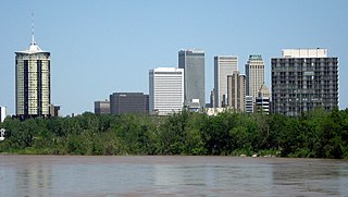
Tulsa is the second-largest city in the state of Oklahoma. It has many diverse neighborhoods due to its size.
The City of Oklahoma City uses Special Zoning Districts as a tool to maintain the character of many neighborhood communities.

The neighborhoods of Milwaukee include a number of areas in southeastern Wisconsin within the state's largest city at nearly 600,000 residents.
Columbus, the state capital and Ohio's largest city, has numerous neighborhoods within its city limits. Neighborhood names and boundaries are not officially defined. They may vary or change from time to time due to demographic and economic variables.
Windsor, Ontario, has a very diverse population, and this diversity is shown in its many neighbourhoods. Windsor has twenty in all, ranging from rural farmland to densely built-up areas.
The city of San Antonio in the U.S. state of Texas is composed of a number of neighborhoods and districts, spreading out surrounding the central Downtown Area.

The University of South Africa (UNISA) is the largest university system in South Africa by enrollment. It attracts a third of all higher education students in South Africa. Through various colleges and affiliates, UNISA has over 400,000 students, including international students from 130 countries worldwide, making it one of the world's mega universities and the only such university in Africa.
The campus of the George Washington University (GW), originated on College Hill, a site bounded by 14th Street, Columbia Road, 15th Street and Florida Avenue, NW in the Columbia Heights neighborhood of Washington, D.C. After relocating to the downtown financial district in the 1880s and then to Foggy Bottom in 1912, GW now has three campuses. Foggy Bottom is the location of the university's main campus in Washington, D.C. Also in Washington's Foxhall neighborhood is the Mount Vernon Campus, formerly the Mount Vernon College for Women. Additionally, the George Washington University Virginia Campus is located in Ashburn, VA.
The R101 is a Regional Route in South Africa that is the designation for some of the old sections of roads that were previously the N1, prior to upgrading. It only has 2 sections, from Bellville to Worcester and from Johannesburg to Polokwane.


