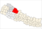
Dadeldhura district, a part of Sudurpashchim Pradesh, is one of the seventy-seven districts of Nepal. The district, with Dadeldhura as its district headquarters, covers an area of 1,538 km2 (594 sq mi) and had a population of 126,162 in 2001 and 142,094 in 2011.

RolpaListen (help·info), is a "hill" district in Lumbini Province of Nepal. Rolpa district covers an area of 1,879 km2 (725 sq mi) with population (2011) of 221,177. Rolpa town is the district's administrative center.

The administrative divisions of Nepal are subnational administrative units of Nepal. The first level of country subdivision of Nepal are the provinces. Each province is further subdivided into districts, each district into municipalities and rural municipalities, and each of those municipalities into wards. Before 2015, instead of provinces, Nepal was divided into developmental regions and administrative zones.

Sotang is one of the 7 rural municipalities of Solukhumbu District of Province No. 1 of Nepal. It was established on 10 March 2017 merging former VDCs Sotang, Pawai and Gudel.

Kharpunath is a rural municipality located in Humla District of Karnali Province of Nepal.

Chulachuli is a rural municipality (gaunpalika) out of six rural municipality located in Ilam District of Province No. 1 of Nepal. There are a total of 10 municipalities in Ilam in which 4 are urban and 6 are rural.
Hatuwagadhi is a rural municipality out of 7 rural municipalities of Bhojpur District of Province No. 1 of Nepal. There are a total of 9 municipalities in Bhojpur in which 2 are urban and 7 are rural.
Aiselukharka is a rural municipality (gaunpalika) out of eight rural municipality located in Khotang District of Province No. 1 of Nepal. There are a total of 10 municipalities in Khotang in which 2 are urban and 8 are rural.
Jantedhunga is a rural municipality (gaunpalika) out of eight rural municipality located in Khotang District of Province No. 1 of Nepal. There are a total of 10 municipalities in Khotang in which 2 are urban and 8 are rural.
Kepilasgadhi is a rural municipality (gaunpalika) out of eight rural municipality located in Khotang District of Province No. 1 of Nepal. There are a total of 10 municipalities in Khotang in which 2 are urban and 8 are rural.
Barahapokhari is a rural municipality (gaunpalika) out of eight rural municipality located in Khotang District of Province No. 1 of Nepal. There are a total of 10 municipalities in Khotang in which 2 are urban and 8 are rural.
Sakela is a rural municipality (gaunpalika) out of eight rural municipality located in Khotang District of Province No. 1 of Nepal. There are a total of 10 municipalities in Khotang in which 2 are urban and 8 are rural.
Aathrai is a rural municipality (gaunpalika) out of four rural municipality located in Tehrathum District of Province No. 1 of Nepal. There are a total of 6 municipalities in Tehrathum in which 2 are urban and 4 are rural.
Menchhayayem is a rural municipality (gaunpalika) out of four rural municipality located in Tehrathum District of Province No. 1 of Nepal. There are a total of 6 municipalities in Tehrathum in which 2 are urban and 4 are rural.
Kaike is a rural municipality located in Dolpa District of Karnali Province of Nepal.
Chharka Tangsong is a rural municipality located in Dolpa District of Karnali Province of Nepal.
Simkot is a rural municipality located in Humla District of Karnali Province of Nepal.
Sarkegad is a rural municipality located in Humla District of Karnali Province of Nepal.
Chankheli is a rural municipality located in Humla District of Karnali Province of Nepal.