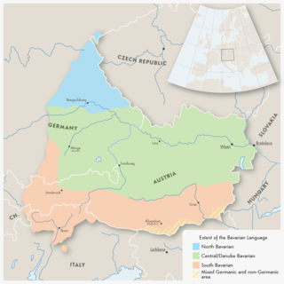
Bavarian is a West Germanic language spoken in parts of Bavaria and most of Austria. Before 1945, Bavarian was also prevalent in parts of the southern Czech Republic and western Hungary. Bavarian forms a continuum of more or less mutually intelligible local and regional variants. Its mutual intelligibility with Standard German is very limited, but most of its speakers can code-switch to Standard German.
The Upper Palatinate is one of the seven administrative districts of Bavaria, Germany, and is located in the east of Bavaria.
Cham is a Landkreis (district) in Bavaria, Germany. It is bounded by the districts of Regen, Straubing-Bogen, Regensburg and Schwandorf and by the Czech Plzeň Region.
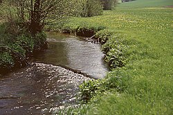
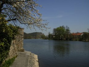
The Regen is a river in Bavaria, Germany, and a left tributary of the Danube, at Regensburg, Germany. The source of its main headstream, the Great Regen, is in the Bohemian Forest on the territory of the Czech Republic, near Železná Ruda. The river crosses the border after a few kilometres, at Bayerisch Eisenstein. The name in German evolved from the name in Latin, but its meaning is unknown. The Romans called the river variously Regana, Reganus (masculine), and Reganum (neuter).
Freyung-Grafenau is a Landkreis (district) in Bavaria, Germany. It is bounded by the districts of Passau, Deggendorf and Regen, the Czech Republic and by Austria.
Regen is a Landkreis (district) in Bavaria, Germany. It is bounded by the districts of Freyung-Grafenau, Deggendorf, Straubing-Bogen and Cham, and by the Czech Republic.

The Bohemian Forest, known in Czech as Šumava and in German as Böhmerwald, is a low mountain range in Central Europe. Geographically, the mountains extend from Plzeň Region and South Bohemia in the Czech Republic to Austria and Bavaria in Germany, and form the highest truncated uplands of the Bohemian Massif, up to 50 km wide. They create a natural border between the Czech Republic on one side and Germany and Austria on the other.
The Duchy of Bavaria was a frontier region in the southeastern part of the Merovingian kingdom from the sixth through the eighth century. It was settled by Bavarian tribes and ruled by dukes (duces) under Frankish overlordship. A new duchy was created from this area during the decline of the Carolingian Empire in the late ninth century. It became one of the stem duchies of the East Frankish realm which evolved as the Kingdom of Germany and the Holy Roman Empire.
The Naab is a river in Bavaria, Germany, and is a left tributary of the Danube. Including its main source river Waldnaab, it is 196.6 km (122 mi) long. Its average discharge at the mouth is 49 m3/s (1,700 cu ft/s).
Southern Germany as a region has no exact boundary but is generally taken to include the areas in which Upper German dialects are spoken. This corresponds roughly to the historical stem duchies of Bavaria and Swabia or, in a modern context, to Bavaria and Baden-Württemberg within the Federal Republic of Germany, to the exclusion of the areas of the modern states of Austria and Switzerland. The Saarland and the southern parts of Hesse and Rhineland-Palatinate are sometimes included as well and correspond to the historical Franconia.

Pfreimd is a river of Plzeň Region, Czech Republic and Bavaria, Germany. It flows into the Naab in the town Pfreimd.

The Wondreb is a river in Bavaria, Germany and Karlovy Vary Region, Czech Republic. It flows into the Ohře (Eger) near the village Odrava.

Hammerbach is a river of Bavaria, Germany and of the Czech Republic. It is a left tributary of the Mže near Kočov.

Schwarzach is a river of Czech Republic and Bavaria, Germany. It is a left tributary of the Naab. It passes through Waldmünchen, Rötz and Neunburg vorm Wald, and flows into the Naab near Schwarzenfeld.
Höllbach is a river of Bavaria, Germany. It is the right headstream of the Schwesnitz in Rehau. For 1.7 km it forms the border between Germany and the Czech Republic. The westernmost point of the Czech Republic is on its left tributary Mähringsbach.

Kalte Moldau is a river of Bavaria, Germany and Czech Republic. It flows into the Vltava near Volary.
Reschbach is a river of Bavaria, Germany. Its source is on the border with the Czech Republic, close to the source of the Vltava. At its confluence with the Saußbach west of Freyung, the Wolfsteiner Ohe is formed.
Saußbach is a river of Bavaria, Germany. The uppermost 4.8 km of its course forms part of the border with the Czech Republic. At its confluence with the Reschbach west of Freyung, the Wolfsteiner Ohe is formed.
Selbbach is a river of the Karlovy Vary Region, Czech Republic and Bavaria, Germany. Its source is west of the town Aš. It flows into the Ohře (Eger) near Selb.
The Southern Regnitz is a river of Czech Republic and Germany. Its source is near the village Hranice, Cheb District. It forms the border of Germany with the Czech Republic in the extreme northeast of Bavaria and then runs into Bavaria to join the Saale river near the city of Hof.