Related Research Articles

Manipur is a state in northeast India, with the city of Imphal as its capital. It is bounded by the Indian states of Nagaland to the north, Mizoram to the south and Assam to the west. It also borders two regions of Myanmar, Sagaing Region to the east and Chin State to the south. The state covers an area of 22,327 km2 (8,621 sq mi). The official and most widely spoken language is the Meitei language. Native to the Meitei people, it is also used as a lingua franca by smaller communities, who speak a variety of other Tibeto-Burman languages. Manipur has been at the crossroads of Asian economic and cultural exchange for more than 2,500 years. This exchange connects the Indian subcontinent and Central Asia to Southeast Asia, East Asia, Siberia, regions in the Arctic, Micronesia and Polynesia enabling migration of people, cultures and religions.

Meitei, also known as Manipuri, is a Tibeto-Burman language of northeast India. It is the official language and the lingua franca of Manipur and one of the official languages of Assam. It is one of the constitutionally scheduled official languages of the Indian Republic. Meitei is the most widely-spoken Tibeto-Burman language of India and third most widely spoken language of northeast India after Assamese and Bengali. There are 1.76 million Meitei native speakers in India according to the 2011 census. Most of these, or 1.52 million, are found in the state of Manipur, where they represent majority of its population. There are smaller communities in neighbouring Indian states, such as Assam (168,000), Tripura (24,000), Nagaland (9,500), and elsewhere in the country (37,500). The language is also spoken by smaller groups in neighbouring Myanmar and Bangladesh.

The Meitei people, Meetei, Manipuri people is an ethnic group native to Manipur. They form the largest and dominant ethnic group of Manipur in Northeast India. They speak the Meitei language, one of the 22 official languages of the Republic of India and the sole official language of Government of Manipur. The Meiteis primarily settled in the Imphal Valley region in modern-day Manipur, though a sizeable population has settled in the other Indian states of Assam, Tripura, Nagaland, Meghalaya, and Mizoram. There is also a notable presence of Meitei people in the neighbouring countries of Myanmar and Bangladesh. The Meitei ethnic group represents about 53% of Manipur's population.

The Meitei Pangals, also known as Meitei Muslims or the Manipuri Muslims, are a group of Meitei Muslims. They live mainly in Manipur. The word Pangal simply means Muslim in the Meitei language. Various historical sources have different dates for when Islam first entered Manipur. However, the date all sources seem to confirm as definitive is 1606 AD. The origin of the Pangal community is equally varied.

The Kuki people are an ethnic group in the Northeastern Indian states of Manipur, Nagaland, Assam, Meghalaya, Tripura and Mizoram, as well as the neighbouring countries of Bangladesh and Myanmar. The Kukis form one of the largest hill tribe communities in this region. In Northeast India, they are present in all states except Arunachal Pradesh. The Chin people of Myanmar and the Mizo people of Mizoram are kindred tribes of the Kukis. Collectively, they are termed the Zo people.
The history of Manipur is reflected by archaeological research, mythology and written history. Historically, Manipur was an independent sovereign kingdom ruled by Meitei dynasty but at different point of time it was invaded and rule over by other state and authority. The Kangleipak State developed under King Loiyumba with its first written constitution in the early 12th century. Manipur under the 18th-century king Pamheiba saw the legendary burning of sacred scripture.

Meitei literature, also known as Manipuri literature, is literature written in the Meitei language of Manipur. An ancient institution of learning, the Luwang Nonghumsang, later known as the Pandit Loishang, collected sources of indigenous Meitei knowledge and philosophy until the 18th century. Writing by Meiteis is assumed to go back to the Kingdom of Kangleipak in the early 12th century. The Meitei script is a Brahmic abugida. It is known only from the Puya manuscripts discovered in the first half of the 20th century. Manuscripts of the 18th and 19th centuries were written using the Bengali alphabet. The existence of the Meitei script in the 15th-century hinges on the authenticity of an inscription dated to the reign of Senbi Kiyamba. The first printed Manipuri book, Manipurer Itihas, appeared in 1890 from the Baptist Mission Press, Calcutta. Though the kings of Manipur had established contact with the British from the middle of the eighteenth century onward the real impact of the contact came much later. Johnstone Middle English School, based on the western system of education, was started in 1885 at Imphal, and in 1891 Manipur lost its independence to the British. British domination facilitated the introduction of new systems in the civil, political and educational spheres, which hastened the process of modernization in Manipur, exposed as it was to new ideas and influences.

The Manipur Kingdom also known as Meckley was an ancient kingdom at the India–Burma frontier. Historically, Manipur was an independent kingdom ruled by a Meitei dynasty. But it was also invaded and ruled over by Burmese kingdom at various point of time. It became a protectorate of the British East India Company from 1824, and a princely state of British Raj in 1891. It bordered Assam Province in the west and British Burma in the east, and in the 20th century covered an area of 22,327 square kilometres and contained 467 villages. The capital of the state was Imphal.

Pakhangba is a primordial deity, often represented in the form of a dragon, in Meitei mythology and Sanamahism, the indigenous religion of Manipur. He is depicted in the heraldry of Manipur kingdom, which originated in paphal, mythical illustrations of the deity. It is believed that the ancestor of one of the Meitei clans manifested himself as the Pakhangba.

The Pratapgarh Kingdom was a medieval state in the north-east of the Indian subcontinent. Composed of the present-day Indian district of Karimganj, as well as parts of Tripura State and Sylhet, Bangladesh, the kingdom was ruled by a line of Muslim monarchs over a mixed population of Hindu and Islamic adherents. It was bordered by the larger kingdoms of Kachar, Tripura and Bengal.

The Greater Sylhet region predominantly included the Sylhet Division in Bangladesh, and Karimganj district in Assam, India. The history of the Sylhet region begins with the existence of expanded commercial centres in the area that is now Sylhet City. Historically known as Srihatta and Shilhatta, it was ruled by the Buddhist and Hindu kingdoms of Harikela and Kamarupa before passing to the control of the Chandra, Sena and Deva dynasties in the early medieval period. After the fall of these Buddhist and Hindu principalities, the region became home to many more independent petty kingdoms such as Jaintia, Gour, Laur, and later Taraf, Pratapgarh, Jagannathpur, Chandrapur and Ita. After the Conquest of Sylhet in the 14th century, the region was absorbed into Shamsuddin Firoz Shah's independent principality based in Lakhnauti, Western Bengal. It was then successively ruled by the Muslim sultanates of Delhi and the Bengal Sultanate before collapsing into Muslim petty kingdoms, mostly ruled by Afghan chieftains, after the fall of the Karrani dynasty in 1576. Described as Bengal's Wild East, the Mughals struggled in defeating the chieftains of Sylhet. After the defeat of Khwaja Usman, their most formidable opponent, the area finally came under Mughal rule in 1612. Sylhet emerged as the Mughals' most significant imperial outpost in the east and its importance remained as such throughout the seventeenth century. After the Mughals, the British Empire ruled the region for over 180 years until the independence of Pakistan and India. There was a complete list of the different amils who governed Sylhet which was recorded in the office of the Qanungoh of Sylhet. However, most complete copies have been lost or destroyed. Dates from letters and seal traces show evidence that the amils were constantly changed. In 1947, when a referendum was held, Sylhet decided to join the Pakistani province of East Bengal. However, when the Radcliffe Line was drawn up, Karimganj district of Barak Valley was given to India by the commission after being pleaded by Abdul Matlib Mazumdar's delegation. Throughout the History of Sylhet, raids and invasions were also common from neighbouring kingdoms as well as tribes such as the Khasis and Kukis.

Nongshaba is a lion god in Sanamahism and Meitei mythology. He is also regarded as a king of the gods. He is credited with producing light in the primordial universe and is regarded as the maker of the sun. He is worshipped by the people of both the Ningthouja clans as well as the Moirang clans. Nongshaba was worshipped by the people of Moirang clan as a lineage deity and regarded as the father of the god Thangching. He is the greatest of the Umang Lais but he made his only son Thangching the chief deity of Moirang.
Mīr Lutfullāh Khān Bahādur Shirāzī, was a Mughal official who held a number of positions during his life such as the Faujdar of Shujabad Sarkar from 1656 to 1658 and the faujdar of Sylhet Sarkar up until 1663.
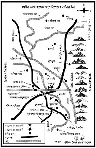
Taraf, previously known as Tungachal, was a feudal territory of the Sylhet region in Bengal and was under many petty kingdoms in different periods of time. It was part of what is present-day Habiganj District in Bangladesh.

Thongalen is the god of the dead and the king of the underworld in Meitei mythology and Sanamahism, the indigenous religion of Manipur. He is the Guardian God of the nadir..
Meitei nationalism refers to nationalism among the Meitei people. In the Meitei context this includes various movements throughout history to sustain Meitei cultural identity, political boundary, ethnicity and history to regain sovereign state status of Kangleipak.
Yumjao Leima or Yumjao Lairembi or Yumjao Lairemma is the mother goddess of house, household, royalty, rule and power in Meitei mythology and religion. She is designated as the all time ruling Queen Mother. Legend says she assumes a human form in white clothes and blesses kings. She is one of the divine incarnations of Leimarel Sidabi.
Laikhurembi is a goddess in Sanamahism, the indigenous religion of Manipur. She is the goddess of justice, good counsel, divine law, order and secrecy. She is the chief Queen of God Thongaren . She is the daughter of Lairen Humchouba. She is one of the divine incarnations of Leimarel Sidabi. She is one of the most important Umang Lais. Her pantheon is maintained particularly by the Taibungjam clan of Meitei ethnicity.
Leima Lainaotabi is a goddess in Sanamahism, the indigenous religion of Manipur. She is the youngest wife of God Thongalel of the underworld kingdom. Thongalel sent her to be the wife of Poireiton, her brother-in-law. Lainaotabi gave birth to a son with Poireiton. Her legend says she made the first clay pot. She was worshipped by the people of Ashangbam clan.
Meidingu Naophangba was a Meetei ruler of Ningthouja dynasty of Ancient Manipur. He is the successor of Naokhamba and the predecessor of Sameiraang. He promulgated a proto-Constitution in 429 AD, which later grew into the Loyumba Shinyen, a written constitution in 1100 AD, during the reign of King Loyumba. He is one of the most outstanding figures in the history of Meitei architecture of Ancient Manipur. He laid the foundation stone of the Kangla, the "Namthak Sarongpung", which is the holiest place to the Manipuri ethnicity. During his reign, the coronation hall in the Kangla was inaugurated and a hog was sacrificed. According to the Loyumba Shinyen, he took command from Mangang Luwang Khuman for the administration of justice in the kingdom. According to the Chakparol, the ten villages of the Chakpas separated during his reign. It was right from his reign that the newcomers (immigrants) were assigned and admitted to the yek salai (clans) and the yumnaks (families) of the Meitei ethnicity. According to the Thengkourol, copper and brass were imported from Burma and China during his reign.
References
- 1 2 Nazir (2013), p. 40.
- ↑ Irene (2010), p. 26.
- 1 2 Khan (2014), p. 117.
- ↑ Sanajaoba (1988), pp. 116, 162.
- ↑ Sanajaoba (1988), pp. 116–17.
- ↑ Nazir (2013), p. 92.
- ↑ Choudhury (2000), pp. 288–90.
- 1 2 Nazir (2013), p. 27.
- ↑ Ali (1965), p. 69.
- 1 2 Sanajaoba (1988), p. 162.
- ↑ Khan (2014), p. 121.
- ↑ Irene (2010), p. 28.
- 1 2 3 Nazir (2013), p. 31.
- ↑ Irene (2010), p. 34.
- 1 2 Irene (2010), p. 9.
- ↑ Khan (2014), pp. 117–18.
- ↑ Kipgen (2010), p. 50.
- 1 2 Khan (2014), p. 132.
- ↑ Irene (2010), pp. 196, 209.
- ↑ Irene (2010), pp. 58, 190.
- ↑ Khan (2014), p. 119.
- ↑ Nazir (2013), pp. 87–90.
- ↑ Irene (2010), p. 194.
- ↑ Nazir (2013), pp. 90–92.