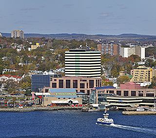
Dartmouth is a built-up community of Halifax Regional Municipality, Nova Scotia, Canada. Located on the eastern shore of Halifax Harbour, Dartmouth has 72,139 residents as of 2021.

The Technical University of Nova Scotia (TUNS) was a Canadian university located in Halifax, Nova Scotia.

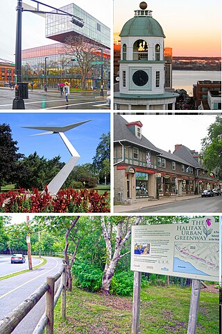
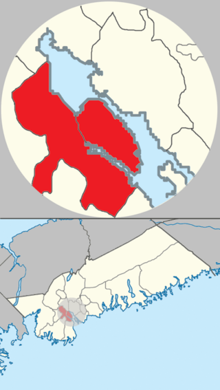
Halifax is the capital and most populous municipality of the Canadian province of Nova Scotia, and the most populous municipality in Atlantic Canada. As of 2023, it is estimated that the population of the Halifax CMA was 518,711, with 348,634 people in its urban area. The regional municipality consists of four former municipalities that were amalgamated in 1996: Halifax, Dartmouth, Bedford, and Halifax County.
Africville was a small community of predominantly African Nova Scotians located in Halifax, Nova Scotia, Canada. It developed on the southern shore of Bedford Basin and existed from the early 1800s to the 1960s. From 1970 to the present, a protest has occupied space on the grounds. The government has recognized it as a commemorative site and established a museum here. The community has become an important symbol of Black Canadian identity, as an example of the "urban renewal" trend of the 1960s that razed similarly racialized neighbourhoods across Canada, and the struggle against racism.

The North End of Halifax is a neighbourhood of Halifax, Nova Scotia occupying the northern part of Halifax Peninsula immediately north of Downtown Halifax.
The Halifax Peninsula is a peninsula within the urban area of the Municipality of Halifax, Nova Scotia.

The Spring Garden Road area, along with Barrington Street is a major commercial and cultural district in Halifax, Nova Scotia, Canada. It acquired its name from the fresh water spring that flows directly beneath it. It comprises Spring Garden Road, South Park Street, and a number of smaller side streets. The area is considered to be one of the trendiest areas in Halifax and is the busiest shopping district east of Quebec.

The South End is a neighbourhood within Halifax's urban area, in the Municipality of Halifax, Nova Scotia, Canada.
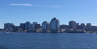
Downtown Halifax is the primary central business district of the Municipality of Halifax. Located on the central-eastern portion of the Halifax Peninsula, on Halifax Harbour. Along with Downtown Dartmouth, and other de facto central business districts within the Municipality, Downtown Halifax serves as the business, entertainment, and tourism hub of the region.

Hosting the region's largest urban population, Halifax, Nova Scotia is an important cultural centre in Atlantic Canada. Halifax is home to a vibrant arts and culture community that enjoys considerable support and participation from the general population. As the largest community and the administrative centre of the Atlantic region since its founding in 1749, Halifax has long-standing tradition of being a cultural generator. While provincial arts and culture policies have tended to distribute investment and support of the arts throughout the province, sometimes to the detriment of more populous Halifax, cultural production in the region is increasingly being recognized for its economic benefits, as well as its purely cultural aspects.
The community of Halifax, Nova Scotia was created on 1 April 1996, when the City of Dartmouth, the City of Halifax, the Town of Bedford, and the County of Halifax amalgamated and formed the Halifax Regional Municipality. The former City of Halifax was dissolved, and transformed into the Community of Halifax within the municipality.

Barrington Street is a major street in Halifax, Nova Scotia, Canada, running from the MacKay Bridge in the North End approximately 7 km south, through Downtown Halifax to Inglis Street in the South End. Its civic numbers range from 950 to 4756 on the Halifax Peninsula street grid numbering system.
Halifax Regional Municipality has many different communities that vary from rural to urban. With a land area of 5,475.57 km2 (2,114.13 sq mi), there are more-than 200 communities-and-neighbourhoods within its boundaries.

Black Nova Scotians are Black Canadians whose ancestors primarily date back to the Colonial United States as slaves or freemen, later arriving in Nova Scotia, Canada, during the 18th and early 19th centuries. As of the 2021 Census of Canada, 28,220 Black people live in Nova Scotia, most in Halifax. Since the 1950s, numerous Black Nova Scotians have migrated to Toronto for its larger range of opportunities. The first recorded free African person in Nova Scotia, Mathieu da Costa, a Mikmaq interpreter, was recorded among the founders of Port Royal in 1604. West Africans escaped slavery by coming to Nova Scotia in early British and French Colonies in the 17th and 18th centuries. Many came as enslaved people, primarily from the French West Indies to Nova Scotia during the founding of Louisbourg. The second major migration of people to Nova Scotia happened following the American Revolution, when the British evacuated thousands of slaves who had fled to their lines during the war. They were given freedom by the Crown if they joined British lines, and some 3,000 African Americans were resettled in Nova Scotia after the war, where they were known as Black Loyalists. There was also the forced migration of the Jamaican Maroons in 1796, although the British supported the desire of a third of the Loyalists and nearly all of the Maroons to establish Freetown in Sierra Leone four years later, where they formed the Sierra Leone Creole ethnic identity.

This timeline of the history of the Halifax Regional Municipality documents all events that had happened in Halifax, Nova Scotia, Canada, including historical events in the former city of Dartmouth, the Town of Bedford and Halifax County. Events date back to the early 18th century and continue until the present in chronological order.

The T-Room is a campus bar located in downtown Halifax, Nova Scotia, on Barrington Street between Spring Garden Road and Morris Street. It was opened in 1937 by Fredrick H. Sexton on the campus of the Nova Scotia Technical College, which is today the Sexton Campus of Dalhousie University. Dr. Sexton served as the first principal, and later president, of NSTC from 1907 to 1947.
The Black Cultural Centre for Nova Scotia is located in Cherry Brook, Nova Scotia, in the Halifax Regional Municipality. The centre is a museum and a library resource centre that focuses on the history and culture of African Nova Scotians. The organization of the Black Cultural Society was incorporated as a charitable organization in 1977 and the centre opened its doors in 1983, with a goal to educate and inspire and to protect, preserve and promote Black culture in Nova Scotia. The centre is located on Trunk 7 at 1149 Main Street.

The Grand Parade is an historic military parade square dating from the founding of Halifax in 1749. At the north end of the Grand Parade is the Halifax City Hall, the seat of municipal government in Nova Scotia's Halifax Regional Municipality. At the south end is St. Paul's Church. In the middle of Grand Parade is the cenotaph built originally to commemorate the soldiers who served in World War I.
The Africville Apology was a formal pronouncement delivered on 24 February 2010 by the City of Halifax, Nova Scotia for the eviction and eventual destruction of Africville, a Black Nova Scotian community.

Peter Alexander Fillmore is a Canadian Liberal politician who has represented the riding of Halifax in the House of Commons of Canada since 2015.
